Furacão FRANCINE (Atlântico 2024 #AL06)

StormRic

Furacão
Registo
23 Jun 2014
Mensagens
27,025
Local
Póvoa de S.Iria (alt. 140m)
E finalmente um furacão, para dia 11 mas de curtíssima vida, bem no extremo Oeste do Atlântico, longe das influências da anómala circulação africana.

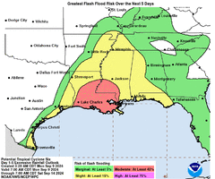
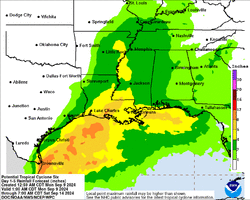
"FORECAST POSITIONS AND MAX WINDS

INIT 09/0900Z 22.2N 94.8W 45 KT 50 MPH...POTENTIAL TROP CYCLONE
12H 09/1800Z 23.0N 95.3W 45 KT 50 MPH...TROPICAL CYCLONE
24H 10/0600Z 24.1N 95.9W 55 KT 65 MPH
36H 10/1800Z 25.2N 95.7W 60 KT 70 MPH
48H 11/0600Z 26.8N 94.8W 65 KT 75 MPH
60H 11/1800Z 28.5N 93.3W 70 KT 80 MPH
72H 12/0600Z 30.7N 91.8W 50 KT 60 MPH...INLAND
96H 13/0600Z 34.9N 90.2W 30 KT 35 MPH...POST-TROPICAL
120H 14/0600Z 37.5N 89.0W 20 KT 25 MPH...POST-TROPICAL"

PTC-6_adv-03A.png


Entretanto, as perturbações a Leste continuam a lutar para fazer nascer algum ciclone nessa zona:
two_atl_7d0_12z.webp
 

Anexos

  • 095139WPCERO_sm.gif
    095139WPCERO_sm.gif
    42.8 KB · Visto: 10
  • 095139WPCQPF_sm.gif
    095139WPCQPF_sm.gif
    43 KB · Visto: 13
Última edição:
'6' é agora a tempestade tropical 'Francine'.
A previsão de intensificação é nesta altura favorável a uma duração como furacão superior a 24 horas, ventos máximos sustentados de 75 nós até ao landfall.

"
FORECAST POSITIONS AND MAX WINDS

INIT 09/1500Z 23.0N 94.9W 45 KT 50 MPH
12H 10/0000Z 24.0N 95.4W 50 KT 60 MPH
24H 10/1200Z 24.9N 95.7W 55 KT 65 MPH
36H 11/0000Z 26.3N 95.0W 65 KT 75 MPH
48H 11/1200Z 28.0N 93.5W 75 KT 85 MPH
60H 12/0000Z 29.7N 92.2W 75 KT 85 MPH...ON THE COAST
72H 12/1200Z 32.4N 90.7W 35 KT 40 MPH...INLAND
96H 13/1200Z 36.2N 89.6W 25 KT 30 MPH...POST-TROPICAL
120H 14/1200Z 37.5N 88.8W 20 KT 25 MPH...POST-TROPICAL

KEY MESSAGES:

1. Francine is forecast to be a hurricane when it reaches the
northwestern Gulf coast on Wednesday or Wednesday night and there is
an increasing likelihood of life-threatening storm surge inundation
for portions of the Upper Texas and Louisiana coastlines where a
Storm Surge Watch is in effect. Residents in the watch area should
follow advice given by local officials.

2. There is an increasing risk of damaging hurricane-force winds in
portions of southern Louisiana beginning Wednesday, where a
Hurricane Watch is now in effect.

3. Francine is expected to bring heavy rainfall and the risk of
considerable flash flooding along the coast of far northeast Mexico,
portions of the southernmost Texas coast, the Upper Texas Coast,
southern Louisiana, and southern Mississippi into Thursday morning.
A risk of flash and urban flooding exists across portions of the
Mid-South from Wednesday into Friday morning. "


PTC-6_adv-04.webp
 
... e o cisalhamento deverá atrapalhar.
Esse factor já está a revelar-se no caso de Francine ainda não passou de TT.
No entanto o NHC insiste num landfall amanhã à tarde em Cat.2/85 nós :intrigante:
Provavelmente para efeitos de prevenção:
"The official intensity forecast is now at the high end of the model guidance. "


FORECAST POSITIONS AND MAX WINDS

INIT 10/0900Z 24.4N 96.2W 55 KT 65 MPH
12H 10/1800Z 25.4N 95.6W 70 KT 80 MPH
24H 11/0600Z 27.1N 94.2W 80 KT 90 MPH
36H 11/1800Z 29.0N 92.5W 85 KT 100 MPH
48H 12/0600Z 31.4N 91.1W 50 KT 60 MPH...INLAND
60H 12/1800Z 33.8N 90.5W 30 KT 35 MPH...INLAND
72H 13/0600Z 35.7N 90.2W 25 KT 30 MPH...POST-TROPICAL
96H 14/0600Z 37.0N 90.0W 20 KT 25 MPH...POST-TROPICAL
120H 15/0600Z...DISSIPATED

Francine_adv-07A.png


Entretanto, de hoje até Domingo há que contar com mais de 150mm numa vasta zona a oeste de New Orleans, incluindo a zona urbana central.
Probabilidade moderada (>40%) de inundações repentinas.

092727WPCQPF_sm.gif


092727WPCERO_sm.gif
 
Última edição:
Esse factor já está a revelar-se no caso de Francine ainda não passou de TT.
No entanto o NHC insiste num landfall amanhã à tarde em Cat.2/85 nós :intrigante:
Provavelmente para efeitos de prevenção:
"The official intensity forecast is now at the high end of the model guidance. "

Pode ter ingerido ar seco tendo em conta a proximidade ao México.

Cisalhamento parece ser muito baixo nas próximas horas. CTs podem fortalecer-se rapidamente no Golfo mas a intensidade final dependerá da eventual ingestão de (mais) ar seco aquando da aproximação à costa.

eGPGeIo.png
 
Pode ter ingerido ar seco tendo em conta a proximidade ao México.

Cisalhamento parece ser muito baixo nas próximas horas. CTs podem fortalecer-se rapidamente no Golfo mas a intensidade final dependerá da eventual ingestão de (mais) ar seco aquando da aproximação à costa.
O NHC (Adv.8) quase a desistir dos 85 nós, mas...

FORECAST POSITIONS AND MAX WINDS

INIT 10/1500Z 24.9N 95.6W 55 KT 65 MPH
12H 11/0000Z 26.0N 94.8W 65 KT 75 MPH
24H 11/1200Z 27.8N 93.2W 80 KT 90 MPH
36H 12/0000Z 29.9N 91.3W 75 KT 85 MPH...INLAND
48H 12/1200Z 32.2N 90.4W 40 KT 45 MPH...INLAND
60H 13/0000Z 34.6N 90.1W 30 KT 35 MPH...INLAND
72H 13/1200Z 35.8N 90.1W 25 KT 30 MPH...POST-TROP/REMNT LOW
96H 14/1200Z 37.0N 90.0W 20 KT 25 MPH...POST-TROP/REMNT LOW
120H 15/1200Z...DISSIPATED

... "Francine has about 24-30 h to strengthen over warm water before it
encounters strong shear near the Louisiana coast. While there is a
possibility that dry air entrainment could reduce the
intensification rate, the intensity continues to call for steady to
rapid strengthening during this time based on the otherwise
favorable conditions. While it is not explicitly shown in the
latest forecast, the cyclone could reach a peak intensity near 85 kt
between the 24 h point and landfall
. Intensification is expected to
stop before landfall, and rapid weakening is expected after
landfall. "
 
"

Andy Hazelton
@AndyHazelton

Just finished our AM mission in Francine. Interesting how the dry air kept trying to keep the core from really tightening up. We'll see if that continues this afternoon. Still forecast to become a hurricane soon and impact Louisiana tomorrow sometime. One more mission for me tomorrow AM! "

Efectivamente o NHC refere esta manutenção da intensidade máxima dos ventos:

"1000 AM CDT Tue Sep 10 2024

Satellite imagery and data from the WSR-88D Doppler radar in
Brownsville indicate that the central core of Francine has become
better organized, with the development of a central dense overcast
and increased convective banding near the center. In addition,
reports from NOAA and Air Force Reserve Hurricane Hunter aircraft
show that the central pressure has fallen to around 988 mb. However,
these developments have not yet resulted an increase in wind speed,
as the aircraft-reported winds still support an intensity near
55 kt this advisory. "

Reflectindo-se no ajustamento por baixo da intensidade até ao landfall.
Também foi ajustada a trajectória um pouco mais para Leste, começando o aviso de furacão a apanhar a costa marítima a sul de New Orleans, parte da cidade entrando no cone de incerteza da passagem do centro de Francine.

Francine_adv-08A.webp
 
80 nós na altura do landfall, mantém-se a previsão:

"103
WTNT61 KNHC 110321
TCUAT1

Hurricane Francine Tropical Cyclone Update
NWS National Hurricane Center Miami FL AL062024
1020 PM CDT Tue Sep 10 2024

...AIR FORCE HURRICANE HUNTERS FIND FRANCINE HAS STRENGTHENED...

Air Force Reserve Hurricane Hunter aircraft data indicate that
Francine has strengthened, with maximum sustained winds near 85 mph
(140 km/h) with higher gusts.


SUMMARY OF 1020 PM CDT...0320 UTC...INFORMATION
---------------------------------------------------
LOCATION...26.4N 94.3W
ABOUT 185 MI...295 KM ENE OF MOUTH OF THE RIO GRANDE
ABOUT 295 MI...475 KM SW OF MORGAN CITY LOUISIANA
MAXIMUM SUSTAINED WINDS...85 MPH...140 KM/H
PRESENT MOVEMENT...NE OR 35 DEGREES AT 10 MPH...17 KM/H
MINIMUM CENTRAL PRESSURE...979 MB...28.91 INCHES

$$
Forecaster Reinhart

Anteriormente:
"
Hurricane Francine Discussion Number 10
NWS National Hurricane Center Miami FL AL062024
1000 PM CDT Tue Sep 10 2024

[...]

FORECAST POSITIONS AND MAX WINDS

INIT 11/0300Z 26.4N 94.3W 65 KT 75 MPH
12H 11/1200Z 27.7N 93.2W 80 KT 90 MPH
24H 12/0000Z 29.7N 91.4W 80 KT 90 MPH...INLAND
36H 12/1200Z 32.0N 90.2W 45 KT 50 MPH...INLAND
48H 13/0000Z 34.2N 89.9W 30 KT 35 MPH...INLAND
60H 13/1200Z 35.5N 89.9W 25 KT 30 MPH...POST-TROP/REMNT LOW
72H 14/0000Z 36.3N 89.8W 25 KT 30 MPH...POST-TROP/REMNT LOW
96H 15/0000Z...DISSIPATED

$$
Forecaster Cangialosi/Hagen "
 
Francine sem surpresas, mantém no máximo os 80 nós, sofre alongamento SW-NE devido ao cisalhamento de sudoeste, olho elíptico e aberto a sul, possível intrusão de ar seco por esse quadrante:

"
Hurricane Francine Discussion Number 12
NWS National Hurricane Center Miami FL AL062024
1000 AM CDT Wed Sep 11 2024
FORECAST POSITIONS AND MAX WINDS

[...]

INIT 11/1500Z 28.0N 92.7W 80 KT 90 MPH
12H 12/0000Z 29.5N 91.5W 80 KT 90 MPH...NEAR COAST
24H 12/1200Z 31.8N 90.3W 40 KT 45 MPH...INLAND
36H 13/0000Z 34.1N 90.1W 30 KT 35 MPH...INLAND
48H 13/1200Z 35.2N 90.3W 20 KT 25 MPH...POST-TROP/EXTRATROP
60H 14/0000Z 35.7N 90.2W 20 KT 25 MPH...POST-TROP/EXTRATROP
72H 14/1200Z...DISSIPATED
$$
Forecaster Beven "

Francine_AL062024_Sandwich_48fr_20240911-1147.gif


Movimento a acelerar, daqui a 24 horas o ciclone já estará bem para o interior, longe da costa e em rápida transição.
O momento de landfall é irrelevante dado não haver uma estrutura significativa do olho, mas ocorrerá daqui a cerca de 6-7 horas (á volta da meia-noite, hora de cá no continente).

Francine_adv-12.webp
 
Prestes a entrar em terra a parede norte do olho:

"
754
WTNT61 KNHC 111956
TCUAT1

Hurricane Francine Tropical Cyclone Update
NWS National Hurricane Center Miami FL AL062024
300 PM CDT Wed Sep 11 2024

...FRANCINE'S EYEWALL NEARING SOUTHERN LOUISIANA...
...300 PM CDT POSITION UPDATE...

Hurricane-force winds in the northern eyewall of Francine are
nearing the coast of southern Louisiana. Now is the time to stay
inside and away from windows. Have multiple ways to receive
warnings and updates.

An oil platform east of the center recently reported sustained
winds of 74 mph (119 km/h) and a peak gust of 92 mph (148 km/h) at
an elevation of 102 ft (31 m).

A NOS station located on Eugene Island recently reported sustained
winds of 54 mph (87 km/h) and a peak gust of 70 mph (113 km/h).

Another position update will be provided at 500 PM CDT (2200 UTC)
following the issuance of the full advisory package at 400 PM CDT
(2100 UTC).

SUMMARY OF 300 PM CDT...2000 UTC...INFORMATION
-----------------------------------------------
LOCATION...28.9N 91.5W
ABOUT 60 MI...95 KM SSW OF MORGAN CITY LOUISIANA
ABOUT 115 MI...185 KM SW OF NEW ORLEANS LOUISIANA
MAXIMUM SUSTAINED WINDS...90 MPH...150 KM/H
PRESENT MOVEMENT...NE OR 40 DEGREES AT 17 MPH...27 KM/H
MINIMUM CENTRAL PRESSURE...975 MB...28.79 INCHES

$$
Forecaster Cangialosi/Bucci

Desde há cerca de duas horas que o furacão começou a evidenciar o olho nas imagens da banda do visível:

20242551930_GOES16-ABI-FL-GEOCOLOR-AL062024-1000x1000.webp