Furacão BERYL (Atlântico 2024 #AL02)

StormRic

Furacão
Registo
23 Jun 2014
Mensagens
27,025
Local
Póvoa de S.Iria (alt. 140m)
Beryl perfeitamente formado com o aspecto de "Major Hurricane".
Nada menos que condições catastróficas a esperar para as ilhas de sotavento, especialmente as Grenadines, mas com a expansão do campo de ventos Grenada e St.Vincent estão incluídas na área de risco extremo.

b65URY2.png


hDtzCFS.gif


Anexos

  • Barbados.webp
    Barbados.webp
    78.7 KB · Visto: 8
  • Carriacou.webp
    Carriacou.webp
    29.5 KB · Visto: 8
  • Mustique.webp
    Mustique.webp
    45 KB · Visto: 10
000
WTNT62 KNHC 301536
TCUAT2

Hurricane Beryl Tropical Cyclone Update
NWS National Hurricane Center Miami FL AL022024
1135 AM AST Sun Jun 30 2024

...RECONNAISSANCE AIRCRAFT FIND BERYL NOW AN EXTREMELY DANGEROUS
CATEGORY 4 HURRICANE...
...LIFE-THREATENING WINDS AND STORM SURGE EXPECTED IN THE WINDWARD
ISLANDS BEGINNING EARLY MONDAY MORNING...

NOAA and Air Force Reserve hurricane hunter aircraft data indicate
that Beryl has strengthened to an extremely dangerous category 4
hurricane. The maximum sustained winds are estimated to be 130 mph
(215 km/h) with higher gusts.


SUMMARY OF 1135 AM AST...1535 UTC...INFORMATION
-----------------------------------------------
LOCATION...10.8N 54.9W
ABOUT 350 MI...565 KM ESE OF BARBADOS
ABOUT 460 MI...740 KM E OF GRENADA
MAXIMUM SUSTAINED WINDS...130 MPH...215 KM/H
PRESENT MOVEMENT...W OR 275 DEGREES AT 21 MPH...33 KM/H
MINIMUM CENTRAL PRESSURE...962 MB...28.41 INCHES

$$
Forecaster Cangialosi

---
Não vejo factores que impeçam a continuação do fortalecimento de Beryl. :(
 
Última edição:
000
WTNT42 KNHC 302035
TCDAT2

Hurricane Beryl Discussion Number 9
NWS National Hurricane Center Miami FL AL022024
500 PM AST Sun Jun 30 2024

After rapidly strengthening for two days straight, Beryl's intensity
appears to have leveled off. The extremely dangerous category 4
hurricane has a circular 10 n mi eye with mesovorticies within it.
However, the convection in the eyewall has become a little less
symmetric over the past few hours as it has eroded a bit on the
south side. The initial intensity is held at 115 kt, which is
near the high end of the latest satellite estimates. Both the NOAA
and Air Force Hurricane Hunters are scheduled to investigate Beryl
again later this evening.

Beryl continues to move swiftly westward at 18 kt steered by a
strong subtropical ridge to its north. A continued relatively
quick westward to west-northwestward motion is expected during the
next several days as subtropical ridging remains the primary
steering feature. Only a minor shift to the north has been made
this cycle, following the trend in the latest models.

Fluctuations in strength are common in major hurricanes in conducive
environments, and it is expected that Beryl will also fluctuate in
strength for the next day or so. There is high confidence that
Beryl will remain an extremely dangerous hurricane through landfall
in the Windward Islands. As the hurricane tracks across the
Caribbean Sea, there likely will be a gradual increase in wind
shear, which should induce a slow weakening trend. However, it
should be emphasized that Beryl is forecast to remain a significant
hurricane during its entire trek across the Caribbean region. The
NHC intensity forecast is an update of the previous one and in good
agreement with the HCCA and IVCN models.


Key Messages:

1. Beryl is expected to remain an extremely dangerous Category 4
hurricane when it reaches the Windward Islands. This is a very
dangerous situation and residents in these areas should listen to
local government and emergency management officials for any
preparedness and/or evacuation orders. All preparations should be
rushed to completion today.

2. Potentially catastrophic hurricane-force winds, a
life-threatening storm surge, and damaging waves are expected when
Beryl passes over portions of the Windward Islands with the highest
risk of the core in St. Vincent and the Grenadines, and Grenada
beginning early Monday morning. Hurricane Warnings are in effect
for much of the Windward Islands.

3. Heavy rainfall and localized flooding are expected across the
Windward Islands through Monday.

4. Beryl is expected to remain a powerful hurricane as it moves
across the Caribbean Sea later this week. A Tropical Storm Watch
has been issued for portions of the southern coast of the Dominican
Republic and Haiti. Interests elsewhere in Hispaniola, Jamaica,
the Cayman Islands, and the remainder of the northwestern Caribbean
should monitor its progress.


FORECAST POSITIONS AND MAX WINDS

INIT 30/2100Z 11.1N 56.5W 115 KT 130 MPH
12H 01/0600Z 11.7N 59.1W 125 KT 145 MPH
24H 01/1800Z 12.8N 62.6W 120 KT 140 MPH
36H 02/0600Z 14.2N 66.3W 110 KT 125 MPH
48H 02/1800Z 15.4N 70.2W 105 KT 120 MPH
60H 03/0600Z 16.4N 74.0W 100 KT 115 MPH
72H 03/1800Z 17.3N 77.7W 95 KT 110 MPH
96H 04/1800Z 18.8N 84.4W 85 KT 100 MPH
120H 05/1800Z 20.3N 89.9W 60 KT 70 MPH...INLAND

$$
Forecaster Cangialosi
 
Ventos máximos 220 Km/h e rajadas até 270Km/h à passagem do quadrante N/NE da parede do olho sobre Carriacou, Petite Martinique, Ashton...

A intensificação rápida de 24 horas levará os ventos máximos sustentados (1 minuto) a aumentar >50%, de 80 para 125 nós (230Km/h) cerca das 6:00utc de hoje dia 1.

Beryl_adv09.png


Beryl_adv09_zoom.png

AumulTotal-3 dias.png

Acumulados totais de 200 a 250mm, localmente em alguma daquelas pequenas ilhas.
 
Última edição:
Última actualização (16h00)

000
WTNT42 KNHC 011457
TCDAT2

Hurricane Beryl Discussion Number 12
NWS National Hurricane Center Miami FL AL022024
1100 AM AST Mon Jul 01 2024

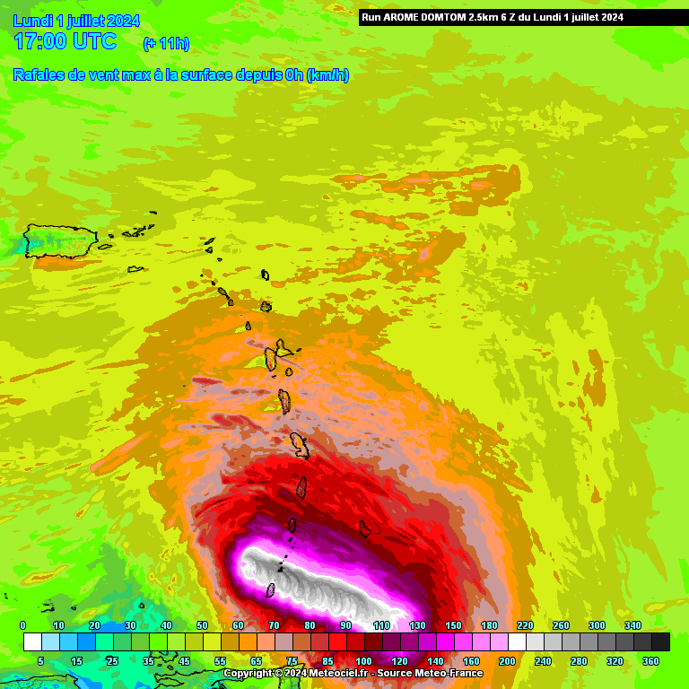
Satellite and radar data this morning suggest Beryl has completed an
eyewall replacement cycle. Radar images from Barbados show a solid
ring of deep convection surrounding the warming, well-defined eye of
the hurricane. Data collected by the NOAA and Air Force Hurricane
Hunters this morning confirm that Beryl has strengthened. Dropsondes
indicate the central pressure has fallen to around 956 mb, and the
earlier flight-level winds and SFMR data supported an intensity of
around 115 kt a couple of hours ago. The hurricane's satellite
structure has continued to improve this morning, and recent
objective satellite estimates justify raising the initial intensity
to 120 kt. The core of the powerful hurricane is nearing Carriacou
Island, Grenada, and the Grenadine Islands, where conditions are
rapidly deteriorating and residents should take action to protect
their lives.

Aircraft and radar fixes indicate Beryl has jogged northwestward
over the past several hours, and the initial estimated motion is
west-northwest or 285/17 kt. The hurricane is currently moving
across the southern Windward Islands. A mid-level steering ridge to
the north of Beryl should steer the hurricane quickly
west-northwestward to westward across the Caribbean Sea during the
next few days as a mid-level ridge strengthens to the north of the
cyclone. This portion of the track forecast is very similar to the
previous advisory, and the NHC forecast remains close to the
multi-model consensus aids. At days 3-5, there is some increased
spread in the track guidance, likely regarding the strength of the
steering ridge as Beryl approaches the northwestern Caribbean Sea
and the Yucatan Peninsula. This portion of the forecast was nudged
slightly north of the previous one, but still lies south of the
consensus aids.

Since the eyewall replacement cycle has completed, the updated NHC
forecast allows for some additional near-term strengthening based on
recent aircraft data and the improved satellite and radar structure
of the hurricane. As previously noted, an increase in westerly shear
is expected by midweek, which is expected to induce some weakening
while Beryl moves across the central and northwestern Caribbean Sea.
This is reflected in the latest NHC prediction that follows the
multi-model consensus trends. Regardless, Beryl is forecast to
remain a powerful hurricane through late this week, and interests in
the northwestern Caribbean and the Yucatan Peninsula should continue
to monitor the latest forecast updates.

Based on the latest NHC forecast, the government of Jamaica has
issued a Hurricane Watch for the island.

Key Messages:

1. The eyewall of Beryl is moving through the southern Windward
Islands. This is an extremely dangerous and life-threatening
situation. Take action now to protect your life! Residents in
Grenada, the Grenadine Islands, and Carriacou Island should not
leave their shelter as destructive winds and life-threatening storm
surge are expected during the next few hours. Shelter in place
through the passage of these life-threatening conditions and do not
venture out in the eye of the storm.


2. Heavy rainfall and localized flash flooding are expected across
the Windward Islands through this afternoon.

3. Beryl is expected to remain a powerful hurricane as it moves
across the Caribbean Sea later this week. A Hurricane Watch has been
issued for Jamaica. Interests in the Cayman Islands, Belize, the
Yucatan Peninsula, and the remainder of the northwestern Caribbean
should monitor its progress. Additional watches and warnings will
likely be required during the next day or two.


FORECAST POSITIONS AND MAX WINDS

INIT 01/1500Z 12.4N 61.3W 120 KT 140 MPH
12H 02/0000Z 13.3N 64.1W 125 KT 145 MPH
24H 02/1200Z 14.5N 67.8W 125 KT 145 MPH
36H 03/0000Z 15.6N 71.7W 110 KT 125 MPH
48H 03/1200Z 16.4N 75.6W 95 KT 110 MPH
60H 04/0000Z 17.2N 79.2W 90 KT 105 MPH
72H 04/1200Z 17.8N 82.6W 80 KT 90 MPH
96H 05/1200Z 19.0N 88.5W 65 KT 75 MPH...INLAND
120H 06/1200Z 20.5N 93.0W 55 KT 65 MPH...OVER WATER

Beryl_adv12_zoom.webp
 
Última edição:
Se esta imagem não está afectada de paralaxe, o olho está sobre Carriacou, e os piores ventos desde Ashton a Canouan.
Depende agora da exposição e do relevo de cada ilha a destruição que pode acontecer.

Um factor a favor de os efeitos não serem tão graves é a rapidez do movimento de Beryl: 30 Km/h. Todo o olho estará a passar em cerca de duas horas ou menos.

DCT_SPECIAL9_1280x720.jpg


GOES16_1km_vis_202407011515_10.75_14.00_-63.50_-59.00_vis1_ltngge_hgwy_warn_weathernerds.webp
 
Última edição: