Furacão BERYL (Atlântico 2024 #AL02)
- Thread starter StormRic
- Data de início
-
O novo portal está no ar! Novos meteogramas, cartas, e mais. Mais informações neste tópico
Seguimento Meteorológico: Litoral Norte | Interior Norte e Centro | Litoral Centro | Sul | Açores e Madeira | Livre
Previsões: Curto e médio prazo: até 2 semanas | Longo prazo: mensal e sazonal (Regras e links úteis nos 1ºs posts)
Facebook | Avisos IPMA/Alertas ANEPC
You are using an out of date browser. It may not display this or other websites correctly.
You should upgrade or use an alternative browser.
You should upgrade or use an alternative browser.


Todos os anos escrevo o mesmo e este não é diferente.
Fascínio com furacões só os meteo-turistas, que estão relativamente isolados das consequências e conseguem monetizar, e os respetivos expectadores que residem longe.
Uma coisa são as TTs e os furacões moribundos cisalhados.
Não queiram estar no caminho de uma besta. Não acaba bem.
Aqui as casas propriamente ditas resistiriam melhor. Mas demasiadas telhas inevitavelmente voariam causando destruição (menor) mas generalizada.
Incrível para esta altura do ano:
000
WTNT42 KNHC 012051
TCDAT2
Hurricane Beryl Discussion Number 13
NWS National Hurricane Center Miami FL AL022024
500 PM AST Mon Jul 01 2024
Beryl has maintained a very impressive satellite appearance this
afternoon. The well-defined, symmetric eye is surrounded by a ring
of infrared cloud tops colder than -70 deg C. The central pressure
of the hurricane was falling throughout the day while the Hurricane
Hunters sampled the storm, with the last aircraft pass showing the
central pressure had fallen to around 946 mb. The latest objective
(ADT/AiDT) and subjective (TAFB/SAB) satellite intensity estimates
still support an intensity between 125 to 130 kt, which lies in
between the earlier reduced flight-level winds and SFMR retrievals
from the aircraft. Thus, the initial intensity of Beryl is held at
130 kt for this advisory.
The hurricane continues to move quickly west-northwestward
(290/18-kt) while being steered by a subtropical ridge over the
western Atlantic. A fast west-northwestward to westward motion is
expected over the next several days, bringing the center of the
hurricane across the central and northwestern Caribbean Sea. The
latest track guidance has shifted a bit northward this cycle, with
some global models including the GFS and ECMWF showing a closer
approach to Hispaniola and Jamaica by midweek. The latest NHC track
forecast was adjusted in this direction, although it still lies
slightly to the south of the TVCA and HCCA aids. The official
prediction still shows Beryl emerging into the southwestern Gulf of
Mexico as a tropical storm at day 5, but the track uncertainty is
greater with more ensemble spread during this period.
The NOAA Hurricane Hunters are scheduled to investigate Beryl again
this evening. While some intensity fluctuations are possible in the
near term, the official NHC forecast shows little intensity change
through tonight. An increase in mid-level westerly shear is still
forecast by midweek, and this should cause some weakening while
Beryl moves across the central and northwestern Caribbean Sea.
However, Beryl is still forecast to remain a hurricane as it
approaches the Yucatan Peninsula. The latest NHC intensity
prediction remains close to the multi-model consensus aids. Once
again, there is increased uncertainty later in the forecast period
regarding the extent of land interaction and vertical depth of the
cyclone once it crosses the Yucatan Peninsula and emerges into the
southwestern Gulf.
Key Messages:
1. Tropical-storm-force winds, dangerous waves, and heavy rainfall
are expected to continue through this evening while the core of
Beryl pulls away from the southern Windward Islands.
2. Beryl is forecast to remain a powerful hurricane as it moves
across the Caribbean Sea later this week. A Tropical Storm Warning
has been issued for the south coast of Hispaniola. Hurricane
conditions are possible in Jamaica on Wednesday, where a Hurricane
Watch is in effect.
3. Interests in the Cayman Islands, Belize, the Yucatan Peninsula,
the remainder of the northwestern Caribbean, and the southwestern
Gulf of Mexico should monitor the progress of Beryl. Additional
watches and warnings will likely be required during the next day or
two.
FORECAST POSITIONS AND MAX WINDS
INIT 01/2100Z 13.2N 63.2W 130 KT 150 MPH
12H 02/0600Z 14.1N 66.0W 130 KT 150 MPH
24H 02/1800Z 15.4N 69.7W 125 KT 145 MPH
36H 03/0600Z 16.3N 73.6W 110 KT 125 MPH
48H 03/1800Z 17.1N 77.2W 95 KT 110 MPH
60H 04/0600Z 17.9N 80.8W 85 KT 100 MPH
72H 04/1800Z 18.3N 84.0W 80 KT 90 MPH
96H 05/1800Z 19.5N 90.0W 60 KT 70 MPH...INLAND
120H 06/1800Z 21.0N 94.0W 55 KT 65 MPH...OVER WATER
$$
Forecaster Reinhart
Não queiram estar no caminho de uma besta. Não acaba bem.
O que se vê naquele vídeo não é, de todo, para experimentar "em casa", seja lá onde fôr.
E mesmo assim, a filmagem não foi certamente realizada na altura de ventos mais intensos. Atrevo-me a dizer que eram inferiores a 160 Km/h.
Última edição:
Categoria 5, 938 hPa, estavam à espera de quê, estamos em terreno inexplorado, certo?
729
WTNT42 KNHC 020252
TCDAT2
Hurricane Beryl Discussion Number 14
NWS National Hurricane Center Miami FL AL022024
1100 PM AST Mon Jul 01 2024
Data from a NOAA-P3 Hurricane Hunter aircraft tonight has been quite
helpful in assessing Beryl's structure and intensity. Within the
past hour, the aircraft measured a peak 700-mb flight-level wind of
157 kt in the northeastern quadrant. A typical 90 percent reduction
translates to a maximum sustained wind of 140 kt, which makes Beryl
a potentially catastrophic Category 5 hurricane. This is the
earliest Category 5 hurricane observed in the Atlantic basin on
record, and only the second Category 5 hurricane to occur in July
after Hurricane Emily in 2005.
Beryl continues to move quickly to the west-northwest, even a bit
faster than earlier, estimated from plane fixes to be 290/19 kt. A
well-established subtropical ridge oriented ESE-to-WNW of Beryl is
expected to continue to steer the small but potent hurricane quickly
west-northwestward into the central Caribbean over the next several
days. After 48 hours, the strongest ridging becomes positioned more
NW of Beryl, and the storm could turn a bit more westward and
gradually slow down when it reaches the northwestern Caribbean. The
guidance this cycle has nudged a bit further north this cycle, and
thus the NHC forecast track has also been shifted in that direction,
roughly between the reliable HCCA and TVCN consensus aids. After 72
hours, model track spread increases quite markedly, especially after
Beryl emerges into the Gulf of Mexico, and forecast confidence in
the track at the end of the forecast is rather low.
While I cannot rule out a bit more intensification in the
short-term, dropsonde pressure observations between fixes in Beryl's
eye have remained steady at 938 mb. It is also possible another
eyewall replacement cycle (ERC) could begin like we saw last night,
with UW-CIMSS MPERC model giving another ERC a 50-75 percent
probability based on the last few microwave passes. With that said,
after the next 24 hours, both the GFS and ECMWF remain insistent
that significant mid-level westerly shear (above 30 kt) will begin
to undercut Beryl's outflow layer. The HAFS-A/B regional-hurricane
models, which did a good job predicting Beryl's peak intensity
today, are also insistent this shear will start to disrupt the
hurricane after the next 24 hours. There is evidence of this less
favorable upper-level pattern on GOES-16 water vapor imagery upwind
of Beryl's track, and thus a faster rate of weakening is forecasted
from 36-72 hours. There remains much uncertainty of what Beryl's
structure or intensity will be as it approaches or crosses the
Yucatan, but the current GFS and ECMWF upper-level pattern in the
Gulf of Mexico does not look especially favorable for
restrengthening at the end of the forecast period.
Key Messages:
1. Beryl is forecast to remain a powerful hurricane as it moves
across the Caribbean Sea later this week. A Hurricane Warning is now
in effect for Jamaica, where hurricane conditions are expected on
Wednesday. A Tropical Storm Warning is also in effect for the south
coast of Hispaniola.
2. Heavy rainfall and flash flooding are possible over portions of
Jamaica on Wednesday.
3. Interests in the Cayman Islands, Belize, the Yucatan Peninsula,
the remainder of the northwestern Caribbean, and the southwestern
Gulf of Mexico should monitor the progress of Beryl. Additional
watches and warnings will likely be required on Tuesday or
Wednesday.
FORECAST POSITIONS AND MAX WINDS
INIT 02/0300Z 13.8N 64.9W 140 KT 160 MPH
12H 02/1200Z 14.8N 67.7W 135 KT 155 MPH
24H 03/0000Z 15.9N 71.5W 125 KT 145 MPH
36H 03/1200Z 16.8N 75.2W 105 KT 120 MPH
48H 04/0000Z 17.7N 78.6W 95 KT 110 MPH
60H 04/1200Z 18.2N 82.2W 85 KT 100 MPH
72H 05/0000Z 18.6N 85.4W 80 KT 90 MPH
96H 06/0000Z 20.5N 91.0W 55 KT 65 MPH...OVER WATER
120H 07/0000Z 22.5N 95.0W 55 KT 65 MPH
$$
Forecaster Papin
Última edição:
Até as últimas notícias estão desactualizadas:
"July 2, 2024 3:18 AM GMT+1Updated an hour ago"
Excepto CNN...
"
Beryl is the earliest major hurricane – defined as one that is Category 3 or higher – in the Atlantic in 58 years. The storm’s rapid intensification is very atypical this early into hurricane season, according to National Hurricane Center Director Mike Brennan. It’s rare for tropical systems to form in the central Atlantic east of the Lesser Antilles in June, particularly strong ones, as only a handful of tropical systems have done so, according to NOAA records.
The storm isn’t just early for this season. It is now the Atlantic Ocean’s third-earliest major hurricane. The earliest was Hurricane Alma on June 8, 1966, followed by Hurricane Audrey, which reached major hurricane status on June 27, 1957.
Beryl has also set the record for the easternmost hurricane to form in the Tropical Atlantic in June, beating a previous record set in 1933.
If Beryl should become a Category 5, it would be the second time an Atlantic hurricane reached this strength in July, following Emily in 2005 — and the earliest Category 5 storm on record. "
Este último recorde também já está assegurado.
Última edição:
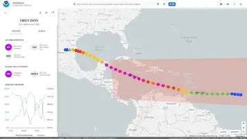
Uma nova "época 2005"?
Emily teve nesse ano uma trajectória e data muito semelhantes às de Beryl, embora este ano as características estão extremadas na data.
Emily teve nesse ano uma trajectória e data muito semelhantes às de Beryl, embora este ano as características estão extremadas na data.
Anexos
Última edição:
Alguma erosão no sector NNW, talvez devido à convecção profunda a desenvolver-se longe do centro. Também uma forte linha de instabilidade a Leste, com alguns topos nos -80ºC.

Isto também poderá significar que Beryl vai aumentar de tamanho?
Isto também poderá significar que Beryl vai aumentar de tamanho?
Intensificou-se, como de resto não era uma hipótese excluída no aviso anterior:
000
WTNT32 KNHC 020549
TCPAT2
BULLETIN
Hurricane Beryl Intermediate Advisory Number 14A
NWS National Hurricane Center Miami FL AL022024
200 AM AST Tue Jul 02 2024
...CATEGORY 5 BERYL STILL INTENSIFYING IN THE SOUTHEASTERN
CARIBBEAN...
...EXPECTED TO BRING LIFE-THREATENING WINDS AND STORM SURGE TO
JAMAICA LATER THIS WEEK...
SUMMARY OF 200 AM AST...0600 UTC...INFORMATION
----------------------------------------------
LOCATION...14.2N 65.8W
ABOUT 445 MI...715 KM ESE OF ISLA BEATA DOMINICAN REPUBLIC
ABOUT 775 MI...1245 KM ESE OF KINGSTON JAMAICA
MAXIMUM SUSTAINED WINDS...165 MPH...270 KM/H
PRESENT MOVEMENT...WNW OR 290 DEGREES AT 22 MPH...35 KM/H
MINIMUM CENTRAL PRESSURE...935 MB...27.61 INCHES
WATCHES AND WARNINGS
--------------------
CHANGES WITH THIS ADVISORY:
None.
Última edição:
O Beryl chegou a Cat 5 e a intensificar, e tornou-se o Cat 5 que apareceu mais cedo desde que há registos.
Se as aguas continuarem a aquecer ano após ano, qualquer dia estão a criar uma nova categoria, Cat 6.
Se as aguas continuarem a aquecer ano após ano, qualquer dia estão a criar uma nova categoria, Cat 6.
Trabalhou na NOAA, selecionado pelo Trump. Viu a luz.

Ainda conseguiu atingir os 145 nós, sempre acima das previsões.
E a passagem do olho ao largo de Kingston mas bastante próximo da costa é um cenário catastrófico pois traz exactamente o pior quadrante sobre esta zona da Jamaica.
"000
WTNT42 KNHC 020859
TCDAT2
Hurricane Beryl Discussion Number 15
NWS National Hurricane Center Miami FL AL022024
500 AM AST Tue Jul 02 2024
Beryl remains an impressive category 5 hurricane this morning.
Satellite imagery shows a well-defined eye, expanding outflow,
and a prominent outer band. Overnight NOAA Hurricane Hunter
aircraft data showed the minimum central pressure falling to about
935 mb, and the Tail Doppler Radar measured 170 kt of wind at about
500 m. This supports the initial intensity of 145 kt for this
advisory.
The hurricane is moving quickly to west-northwest at an estimated
290/19 kt. A strong subtropical ridge centered over the southern
United States will continue to steer Beryl west-northwestward to
westward across the central and northwestern Caribbean for the next
few days. The latest track forecast has been nudged slightly to the
north and lies closest to the corrected consensus aid. There is
still increased uncertainty in the track forecast beyond 72 h, with
the model guidance showing a large spread as Beryl emerges over the
Gulf of Mexico.
Beryl's intensity forecast is also rather uncertain. Model guidance
all indicates that the hurricane will begin to weaken later today
as Beryl encounters moderate-to-strong vertical wind shear. Later
on, factors such as the possible interaction with the Jamaican
elevated terrain, dry air intrusions, and the structure of the
vertical wind shear will all play a role in the rate of weakening.
The models show quite a wide range of solutions, with guidance
between a strong tropical storm to a major hurricane while it nears
the Yucatan Peninsula. The NHC forecast lies in the middle of the
aids, showing Beryl as a major hurricane near Jamaica, reaching
Yucatan as a hurricane in about 72 h before emerging as a tropical
storm over the Gulf of Mexico. This is quite an uncertain forecast
beyond a couple of days due to the aforementioned factors.
Key Messages:
1. Beryl is forecast to remain a powerful hurricane as it moves
across the Caribbean Sea later this week. A Hurricane Warning is in
effect for Jamaica, where hurricane conditions are expected on
Wednesday. A Tropical Storm Warning is also in effect for the south
coast of Hispaniola, and a Hurricane Watch is now in effect for all
of the Cayman Islands.
2. Heavy rainfall and flash flooding are likely over much of Jamaica
on Wednesday.
3. Interests in Belize, the Yucatan Peninsula, Cuba, and the
southwestern Gulf of Mexico should monitor the progress of Beryl.
Additional watches and warnings will likely be required later today
or Wednesday.
FORECAST POSITIONS AND MAX WINDS
INIT 02/0900Z 14.6N 66.9W 145 KT 165 MPH
12H 02/1800Z 15.5N 69.6W 135 KT 155 MPH
24H 03/0600Z 16.5N 73.4W 120 KT 140 MPH
36H 03/1800Z 17.4N 76.8W 105 KT 120 MPH
48H 04/0600Z 18.2N 80.2W 95 KT 110 MPH
60H 04/1800Z 18.7N 83.6W 85 KT 100 MPH
72H 05/0600Z 19.3N 86.7W 80 KT 90 MPH
96H 06/0600Z 21.2N 91.8W 55 KT 65 MPH
120H 07/0600Z 23.0N 95.5W 55 KT 65 MPH
$$
Forecaster Bucci/Blake
Última edição:
Snifa
Furacão
Furacão Beryl ganha força a caminho da Jamaica e ameaça ser uma catástrofe.
Reuters
2 de Julho de 2024, 15:42
Beryl representa um início feroz e precoce da temporada de furacões no Atlântico. Alterações climáticas terão contribuído para a sua invulgar intensidade.
Beryl é agora uma tempestade de categoria 5.
O furacão Beryl ganhou ainda mais força esta segunda-feira, tornando-se uma tempestade "potencialmente catastrófica" de categoria 5, à medida que se deslocava pelo leste das Caraíbas, tendo agora a Jamaica no seu caminho, depois de derrubar linhas eléctricas e inundar ruas noutros locais.
Pelas 12h de segunda-feira, Beryl, com ventos de até 257 kph (quilómetros/hora), estava a cerca de 1352 km a leste-sudeste de Kingston, a capital jamaicana, disse o Centro Nacional de Furacões dos EUA (NHC, na sigla em inglês).
O Beryl é agora um furacão de categoria 5 potencialmente catastrófico", declarou o NHC em comunicado, acrescentando que se espera que traga ventos que põem em risco a vida das pessoas e uma vaga de tempestade à Jamaica no final desta semana. A tempestade pode despejar entre 10 cm e 20 cm de chuva esta quarta-feira, chegando a 31 cm em algumas áreas, avisaram os especialistas.
Jamaicanos à espera.
A Jamaica emitiu um aviso de furacão na segunda-feira, enquanto os avisos de tempestade tropical estavam em vigor para partes da costa sul da República Dominicana e do Haiti.
No restaurante Chillin", em Kingston, o empregado Welton Anderson disse sentir-se calmo apesar da aproximação do furacão. "Os jamaicanos esperam até ao último minuto", disse ele. "Na noite anterior ou de manhã, o pânico instala-se. É porque estamos habituados a isto."
https://www.publico.pt/2024/07/02/azul/noticia/furacao-beryl-ganha-forca-caminho-jamaica-ameaca-catastrofe-2096018
Partilhar: