000
WTNT64 KNHC 082130
TCUAT4
Hurricane Milton Tropical Cyclone Update
NWS National Hurricane Center Miami FL AL142024
430 PM CDT Tue Oct 08 2024
...AIRCRAFT MEASURES VERY LOW PRESSURE IN THE EYE OF MILTON...
Recent observations from an Air Force Reserve Hurricane Hunter
aircraft indicate the central pressure in the eye of Milton has
fallen to an estimated 905 mb (26.72 inches). The aircraft
observations also indicate that the maximum sustained winds are
near 165 mph (270 km/h).
SUMMARY OF 430 PM CDT...2130 UTC...INFORMATION
-----------------------------------------------
LOCATION...22.7N 87.4W
ABOUT 315 MI...510 KM WSW OF THE DRY TORTUGAS
ABOUT 475 MI...770 KM SW OF TAMPA FLORIDA
MAXIMUM SUSTAINED WINDS...165 MPH...270 KM/H
PRESENT MOVEMENT...ENE OR 75 DEGREES AT 9 MPH...15 KM/H
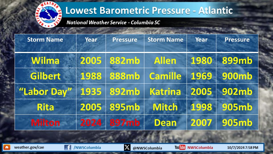
MINIMUM CENTRAL PRESSURE...905 MB...26.72 INCHES
$$
Forecaster Pasch/Berg/Hagen
Mais uma ligeira descida da pressão: 902 hPa neste altura.
"
BULLETIN
Hurricane Milton Intermediate Advisory Number 15A
NWS National Hurricane Center Miami FL AL142024
700 PM CDT Tue Oct 08 2024
...MILTON WILL BRING LIFE-THREATENING STORM SURGE AND WINDS TO
PORTIONS OF THE FLORIDA GULF COAST...
SUMMARY OF 700 PM CDT...0000 UTC...INFORMATION
----------------------------------------------
LOCATION...23.0N 86.9W
ABOUT 280 MI...450 KM WSW OF THE DRY TORTUGAS
ABOUT 440 MI...710 KM SW OF TAMPA FLORIDA
MAXIMUM SUSTAINED WINDS...165 MPH...270 KM/H
PRESENT MOVEMENT...ENE OR 70 DEGREES AT 10 MPH...17 KM/H
MINIMUM CENTRAL PRESSURE...902 MB...26.64 INCHES
Cat.5 nesta altura.
Milton irá manter-se como Major Hurricane até ao landfall, pode até ser em categoria 4.
Hurricane Milton Discussion Number 16
NWS National Hurricane Center Miami FL AL142024
1000 PM CDT Tue Oct 08 2024
NOAA and Air Force Hurricane Hunter aircraft have been investigating
Milton again this evening, providing a number of center fixes,
flight-level wind data, dropsonde measurements, and other valuable
observations. Data from the aircraft confirmed that the hurricane
had regained category 5 intensity, with maximum winds near 145 kt
and the central pressure as low as 902 mb. More recent aircraft
observations showed that the central pressure had risen somewhat, so
the advisory intensity is adjusted slightly down, to 140 kt. This
is also consistent with the latest subjective Dvorak intensity
estimates from both TAFB and SAB.
Center fixes from the aircraft and satellite images indicate that
Milton's heading is gradually turning toward the left and the
initial motion estimate is now about 055/10 kt. The system is being
steered by the flow between a trough digging over the Gulf of Mexico
and a ridge near the Greater Antilles. Milton should move
northeastward on Wednesday with a slight increase in forward speed,
with the center of the hurricane reaching the Florida Gulf coast in
24 hours or so. Thereafter, the system should turn
east-northeastward to eastward and move over the southwestern
Atlantic off the southeast U.S. coast. The official track forecast
is very similar to the previous one, and is generally a little north
of the model trackers, but follows the actual model predicted
cyclone center locations. This is close to a blend of the latest
GFS and ECMWF model solutions. Again, it is critical to remember
that even at 24 hours out, it is still not possible to pinpoint an
an exact landfall location.
Milton is expected to maintain major hurricane strength while it
moves across the eastern Gulf of Mexico and approaches the west
coast of Florida. Although an expected increase in vertical wind
shear should cause some weakening, Milton is expected to still be an
extremely dangerous major hurricane when it reaches shore. Also,
the first stages of extratropical transition may be just underway as
Milton reaches the coast, which could impart some baroclinic energy
and slow the rate of weakening. The NHC intensity forecast is near
the upper side of the intensity model guidance. After Milton moves
over the Atlantic, the global models show the system becoming
embedded within a frontal zone, so the official forecast shows the
system becoming extratropical by 72 hours.
Milton's wind field is expected to grow considerably in size by the
time the center moves over Florida. In addition, a large region of
tropical storm and hurricane force winds could occur on the
northwest/back side of the storm since Milton will be interacting
with a frontal boundary and beginning extratropical transition.
Damaging winds, life-threatening storm surge, and heavy rainfall
will extend well outside the forecast cone. This is a very serious
situation and residents in Florida should closely follow orders from
their local emergency management officials. Evacuations and other
preparations should be completed tonight. Milton has the potential
to be one of the most destructive hurricanes on record for
west-central Florida.
Key Messages:
1. A large area of destructive storm surge, with highest inundations
of 10 ft or greater, is expected along a portion of the west-central
coast of the Florida Peninsula. If you are in the Storm Surge
Warning area, this is an extremely life-threatening situation, and
you should evacuate as soon as possible if ordered by local
officials. There will likely not be enough time to wait to leave on
Wednesday.
2. Devastating hurricane-force winds are expected along portions of
the west coast of Florida, where a Hurricane Warning is in effect.
Milton is forecast to remain a hurricane while it crosses the
Florida Peninsula and life-threatening hurricane-force winds,
especially in gusts, are expected to spread inland across the
peninsula. Preparations to protect life and property, including
being ready for long-duration power outages, should be rushed to
completion.
3. Heavy rainfall across the Florida Peninsula through Thursday
brings the risk of catastrophic and life-threatening flash and urban
flooding along with moderate to major river flooding, especially in
areas where coastal and inland flooding combine to increase the
overall flood threat.
BULLETIN
Hurricane Milton Advisory Number 16
NWS National Hurricane Center Miami FL AL142024
1000 PM CDT Tue Oct 08 2024
...MILTON EXPECTED TO MAKE LANDFALL ON THE GULF COAST OF FLORIDA
LATE WEDNESDAY AS A DANGEROUS MAJOR HURRICANE...
SUMMARY OF 1000 PM CDT...0300 UTC...INFORMATION
-----------------------------------------------
LOCATION...23.4N 86.5W
ABOUT 245 MI...395 KM WSW OF THE DRY TORTUGAS
ABOUT 405 MI...650 KM SW OF TAMPA FLORIDA
MAXIMUM SUSTAINED WINDS...160 MPH...260 KM/H
PRESENT MOVEMENT...NE OR 55 DEGREES AT 12 MPH...19 KM/H
MINIMUM CENTRAL PRESSURE...915 MB...27.02 INCHES
Category 5 storm due to hit Gulf Coast late Wednesday or early Thursday
Size and rare path of storm pose extreme danger from storm surge
Traffic jams and fuel shortages as thousands flee coastal zone
TAMPA, Florida, Oct 9 (Reuters) - Floridians on Wednesday had one final day to evacuate or hunker down ahead of the Category 5 Hurricane Milton, potentially one of the most destructive ever to hit the Gulf Coast of Florida.
With more than 1 million people in coastal areas under evacuation orders, those fleeing for higher ground clogged highways and gas stations ran out of fuel, further rattling a region still recovering from the devastating impacts of Hurricane Helene less than two weeks ago. "