Previsão e Seguimento Furacões (Atlântico 2017)
- Thread starter Felipe Freitas
- Data de início
-
O novo portal está no ar! Novos meteogramas, cartas, e mais. Mais informações neste tópico
Seguimento Meteorológico: Litoral Norte | Interior Norte e Centro | Litoral Centro | Sul | Açores e Madeira | Livre
Previsões: Curto e médio prazo: até 2 semanas | Longo prazo: mensal e sazonal (Regras e links úteis nos 1ºs posts)
Facebook | Avisos IPMA/Alertas ANEPC
You are using an out of date browser. It may not display this or other websites correctly.
You should upgrade or use an alternative browser.
You should upgrade or use an alternative browser.
luismeteo3
Furacão
NHC: At 500 AM AST (0900 UTC).... Hurricane-force winds extend outward up to 30 miles from the
center and tropical-storm-force winds extend outward up to 125 miles.
DOMINICA PRIME MINISTER: "WIDESPREAD DEVASTATION... WE HAVE LOST ALL..."
Puerto Rico governor, Ricardo Rosselló: "Maria will have a much greater impact on the island than Hurricane Irma. Maria will devastate most of Puerto Rico..."
Última edição:
luismeteo3
Furacão
ZCZC MIATCUAT5 ALL
TTAA00 KNHC DDHHMM
Hurricane Maria Tropical Cyclone Update
NWS National Hurricane Center Miami FL AL152017
510 AM AST Tue Sep 19 2017
...MARIA REGAINS CATEGORY 5 STRENGTH...
Recent reports from an Air Force Reserve Hurricane Hunter
aircraft indicate that Maria has reintensified to category 5
status, with estimated maximum sustained winds of 160 mph (260
km/h).
SUMMARY OF 510 AM AST...0910 UTC...INFORMATION
---------------------------------------------------
LOCATION...16.0N 62.3W
ABOUT 65 MI...100 KM WSW OF GUADELOUPE
ABOUT 205 MI...325 KM SE OF ST. CROIX
MAXIMUM SUSTAINED WINDS...160 MPH...260 KM/H
PRESENT MOVEMENT...WNW OR 300 DEGREES AT 9 MPH...15 KM/H
MINIMUM CENTRAL PRESSURE...930 MB...27.46 INCHES
$$
Forecaster Pasch
NNNN
luismeteo3
Furacão
AMFC
Nimbostratus
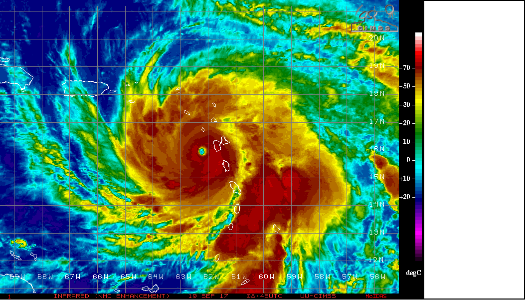
Que imagem impressionante, vai ser a tragédia total em Puerto Rico e US Virgin Islands 

Última edição:
luismeteo3
Furacão
AMFC
Nimbostratus
Live cam us virgin islands www.earthcam.com/usa/virginislands/stcroix/?cam=mmstcroix_hd
Aristocrata
Super Célula
Imagino a devastação que terá ocorrido na Dominica e mesmo em Guadalupe.
O trajecto do furacão Maria está agora um pouco acima do que eu esperava, não atingindo Porto Rico na face Oeste mas provavelmente na Este. Com a intensidade de categoria 4 forte ou 5 fraco, os estragos poderão ser imensos também.
Livre (aparentemente) estão o Haiti e a República Dominicana em parte (a vertente este também deverá contar com mau tempo, mas com infra-estruturas bem melhores que as do Haiti...).
E felizmente que este sistema tropical é bem mais pequeno do que o Irma, por exemplo. O raio de acção dos ventos mais fortes é de 45 km e os de tempestade tropical é de 205 Km. Por comparação o Irma era um monstro de mais de 600 km de raio.
luismeteo3
Furacão
STATEMENT BY PRIME MINISTER ROOSEVELT SKERRIT ON THE OUTCOME OF HURRICANE MARIA
Issued via OECS Commission @ 1:13 am, Tuesday 19th September 2017
Initial reports are of widespread devastation. So far we have lost all what money can buy and replace. My greatest fear for the morning is that we will wake to news of serious physical injury and possible deaths as a result of likely landslides triggered by persistent rains.
So, far the winds have swept away the roofs of almost every person I have spoken to or otherwise made contact with. The roof to my own official residence was among the first to go and this apparently triggered an avalanche of torn away roofs in the city and the countryside.
Come tomorrow morning we will hit the road, as soon as the all clear is given, in search of the injured and those trapped in the rubble.
I am honestly not preoccupied with physical damage at this time, because it is devastating...indeed, mind boggling. My focus now is in rescuing the trapped and securing medical assistance for the injured.
We will need help, my friends, we will need help of all kinds.
It is too early to speak of the condition of the air and seaports, but I suspect both will be inoperable for a few days. That is why I am eager now to solicit the support of friendly nations and organisations with helicopter services, for I personally am eager to get up and get around the country to see and determine what's needed.
luismeteo3
Furacão
ZCZC MIATCPAT5 ALL
TTAA00 KNHC DDHHMM
BULLETIN
Hurricane Maria Intermediate Advisory Number 13A
NWS National Hurricane Center Miami FL AL152017
800 AM AST Tue Sep 19 2017
...POTENTIALLY CATASTROPHIC HURRICANE MARIA HEADED FOR THE VIRGIN
ISLANDS AND PUERTO RICO...
SUMMARY OF 800 AM AST...1200 UTC...INFORMATION
----------------------------------------------
LOCATION...16.2N 62.8W
ABOUT 85 MI...135 KM W OF GUADELOUPE
ABOUT 170 MI...275 KM SE OF ST. CROIX
MAXIMUM SUSTAINED WINDS...160 MPH...260 KM/H
PRESENT MOVEMENT...WNW OR 300 DEGREES AT 9 MPH...15 KM/H
MINIMUM CENTRAL PRESSURE...933 MB...27.55 INCHES
luismeteo3
Furacão
...JOSE STILL A CATEGORY 1 HURRICANE... ...EXPECTED TO PRODUCE DANGEROUS SURF AND RIP CURRENTS ALONG THE EAST COAST OF THE UNITED STATES FOR SEVERAL MORE DAYS...
8:00 AM EDT Tue Sep 19
Location: 36.3°N 71.6°W
Moving: N at 9 mph
Min pressure: 973 mb
Max sustained: 75 mph
8:00 AM EDT Tue Sep 19
Location: 36.3°N 71.6°W
Moving: N at 9 mph
Min pressure: 973 mb
Max sustained: 75 mph
More than half of Puerto Rico's population resides in the San Juan metropolitan area, and eight urban communities—a total population of almost two and a half million people—surround the estuary’s sensitive habitats.
NOAA
PR tem algo como 3.5 milhões de pessoas.
Por agora está previsto que o olho que passe mais ou menos entre a Serra de Luguillo e a Cordilheira Central, voltando para o oceano ligeiramente a oeste de S. Juan. Esta cidade, e arredores, levaria com a maior intensidade do flanco nordeste do olho.

A sudeste de PR está a ilha de Vieques com +-9500 pessoas. Não faria mal nenhum se fosse evacuada já que o olho passará muito próximo.
A próxima ilha a ser atingida será St. Croix, Ilhas Virgens Americanas. Do que consegui apurar os danos do Irma foram mínimos. O governador lá do sítio ficou contente cedo de mais. Estava à espera de mais visitantes devido aos danos nas ilhas vizinhas. As restantes ilhas Virgens Americanas também podem sofrer mais danos mas isto deverá dever-se mais às ondas do que do vento tendo em conta a abrangência dos ventos mais fortes.
Relembro o estado calamitoso em que PR está.
Almost half of the island’s population lives in poverty and 12 percent are unemployed.
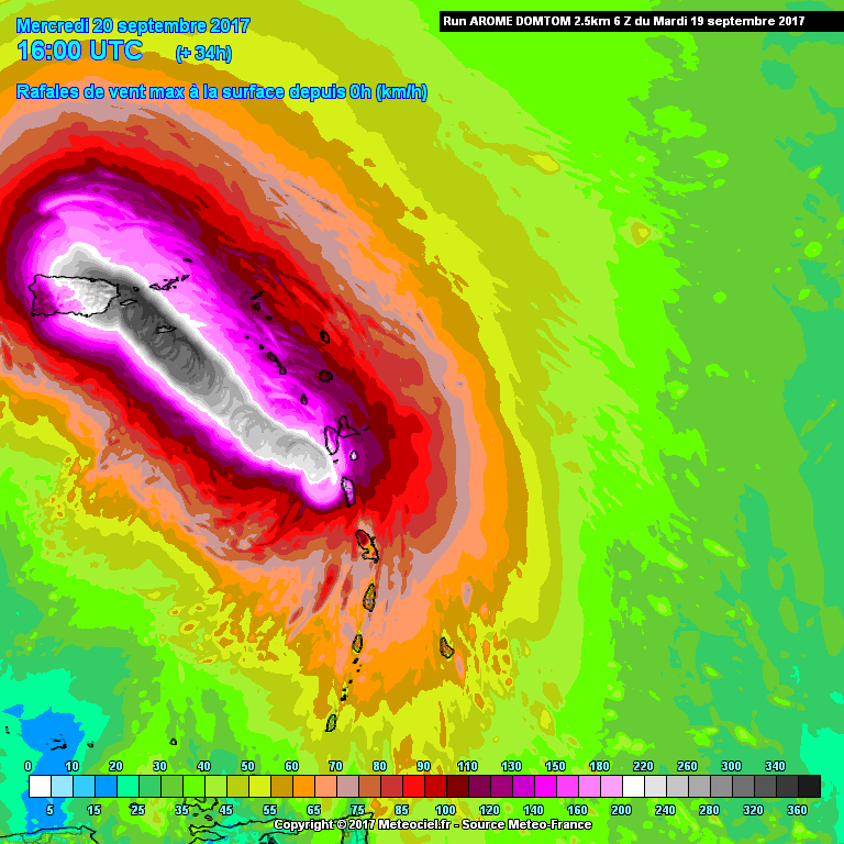
Na previsão até aparece uma rajada de 300 km/h (163 nós)
 Nas elevações mais altas de PR certamente poderá chegar a isso.
luismeteo3
Furacão
NOAA
PR tem algo como 3.5 milhões de pessoas.
Por agora está previsto que o olho que passe mais ou menos entre a Serra de Luguillo e a Cordilheira Central, voltando para o oceano ligeiramente a oeste de S. Juan. Esta cidade, e arredores, levaria com a maior intensidade do flanco nordeste do olho.

A sudeste de PR está a ilha de Vieques com +-9500 pessoas. Não faria mal nenhum se fosse evacuada já que o olho passará muito próximo.
A próxima ilha a ser atingida será St. Croix, Ilhas Virgens Americanas. Do que consegui apurar os danos do Irma foram mínimos. O governador lá do sítio ficou contente cedo de mais. Estava à espera de mais visitantes devido aos danos nas ilhas vizinhas. As restantes ilhas Virgens Americanas também podem sofrer mais danos mas isto deverá dever-se mais às ondas do que do vento tendo em conta a abrangência dos ventos mais fortes.
Relembro o estado calamitoso em que PR está.
Na previsão até aparece uma rajada de 300 km/h (163 nós)Nas elevações mais altas de PR certamente poderá chegar a isso.


O olho da Maria deverá passar próximo desta bóia  http://www.ndbc.noaa.gov/station_page.php?station=42060&unit=M&tz=STN

Com alguma sorte entra no olho. Por agora, ondas nos 7 metros, PC nos 991 hPa e rajadas nos 118 km/h.
---
Vai depender da posição do olho. As ilhas de St. Thomas e St. Croix (ilhas virgens americanas a leste de PR) podem voltar a experienciar ventos severos.
 http://www.ndbc.noaa.gov/station_page.php?station=42060&unit=M&tz=STN
Com alguma sorte entra no olho. Por agora, ondas nos 7 metros, PC nos 991 hPa e rajadas nos 118 km/h.
---
Vai depender da posição do olho. As ilhas de St. Thomas e St. Croix (ilhas virgens americanas a leste de PR) podem voltar a experienciar ventos severos.
Última edição:
luismeteo3
Furacão
Partilhar:


