Previsão e Seguimento de Furacões (Atlântico 2024)

120 nós, e está a ficar maior e ligeiramente mais a sul.

y49Q1d2.png
 
Última edição:
Qualquer pequeno desvio a esta distância fará uma grande diferença para toda esta área. Talvez o westerly shear faça finalmente ainda a tempo o seu papel de domador desta "besta".
Sim, pequenas diferenças mas que podem significar muito: nestes últimos avisos a trajectória gráfica foi puxada ligeiramente para sul e assim poderá não haver landfall, ou seja pelo menos nenhuma zona passará pelos ventos mais fortes e inversão de direcção de 180ºC típica da passagem do olho.
Beryl está a apanhar "pancada", sem dúvida, mas ainda nos 125 nós, não deixa de ser um Cat.4 "Major Hurricane" :(

401
WTNT42 KNHC 031447
TCDAT2

Hurricane Beryl Discussion Number 20
NWS National Hurricane Center Miami FL AL022024
1100 AM EDT Wed Jul 03 2024

Westerly shear is having an effect on Beryl this morning, as the eye
has all but disappeared in satellite imagery and the cloud pattern
has become ragged and elongated from southwest to northeast.
Reports from NOAA and Air Force Reserve Hurricane Hunter aircraft
indicate that the central pressure has risen to near 954 mb.
However, the Air Force plane measured flight-level winds of 139 kt
at 700 mb, while the NOAA plane measured 138-kt winds at 750 mb.
These winds support surface winds of 120-125 kt, and based on this
the initial intensity is held at 125 kt.

The initial motion is now 285/16. A strong mid-level ridge centered
over the southeastern US is expected to continue steering Beryl
generally west-northwestward at a decreasing speed for the next
couple of days or so. The motion should bring the center near or
just south of Jamaica during the next 6-12 h and south of the Cayman
Islands tonight.


SUMMARY OF 800 AM EDT...1200 UTC...INFORMATION
----------------------------------------------
LOCATION...16.9N 75.3W
ABOUT 125 MI...200 KM SE OF KINGSTON JAMAICA
ABOUT 430 MI...690 KM ESE OF GRAND CAYMAN
MAXIMUM SUSTAINED WINDS...145 MPH...230 KM/H
PRESENT MOVEMENT...WNW OR 285 DEGREES AT 20 MPH...31 KM/H
MINIMUM CENTRAL PRESSURE...952 MB...28.11 INCHES


Também está a desacelerar no seu movimento, o que não é bom, significa demorar-se mais em cada sítio onde passa.
No entanto, a vista de satélite mostra erosão da convecção no quadrante Leste e diminuição também da estrutura a norte (efeito do shear a noroeste e poeiras a leste?)
Parece-me agora claro que o olho (pouco visível) não entrará em terra, pelo menos totalmente, mas a parede do olho que restar ainda pode devastar a zona anteriormente referida.

Ver anexo 13052

DCT_SPECIAL17_15utc.jpg


Beryl_adv19A.png
 
Última edição:
Beryl a tentar reorganizar o olho e a estrutura geral. Nova convecção profunda, topos -80ºC no sector norte, chuva intensa já atinge a zona Leste da Jamaica.

Beryl-IR_1525.gif


"
Reports from NOAA and Air Force Reserve Hurricane Hunter aircraft
indicate that the central pressure has risen to near 954 mb.
However, the Air Force plane measured flight-level winds of 139 kt
at 700 mb, while the NOAA plane measured 138-kt winds at 750 mb.
These winds support surface winds of 120-125 kt, and based on this
the initial intensity is held at 125 kt. "

Mantém os 125 nós no último Aviso.

FORECAST POSITIONS AND MAX WINDS

INIT 03/1500Z 17.1N 76.1W 125 KT 145 MPH
12H 04/0000Z 17.8N 78.7W 115 KT 130 MPH
24H 04/1200Z 18.5N 82.3W 100 KT 115 MPH
36H 05/0000Z 19.0N 85.5W 90 KT 105 MPH
48H 05/1200Z 19.7N 88.2W 75 KT 85 MPH...INLAND
60H 06/0000Z 20.5N 90.7W 50 KT 60 MPH...OVER WATER
72H 06/1200Z 21.5N 92.9W 55 KT 65 MPH
96H 07/1200Z 23.5N 96.0W 65 KT 75 MPH
120H 08/1200Z 25.5N 98.0W 55 KT 65 MPH...INLAND

Kingston pode ser poupada aos ventos com força de furacão, olho irá passar relativamente afastado da ponta sul da ilha.
Beryl manter-se-á em Categoria 4 (> 113 nós vento máximo) durante toda a passagem com o centro a sul sobre a água, provavelmente sem a parede norte do olho entrar significativamente em terra.
Beryl_adv20_zoom.webp
 
Última edição:
Seguimento do Furacão BERYL passa para tópico dedicado:

-> Furacão BERYL (Atlântico 2024 #AL02)

Sempre que acharem que se justifique (majors, ou sistemas perto de Portugal Continental ou Ilhas) qualquer membro tem a liberdade de criar tópicos dedicados. ;)
 

Ambiente favorável no Golfo mas não chega a furacão? :intrigante:

000
WTNT44 KNHC 021459
TCDAT4

Potential Tropical Cyclone Four Discussion Number 1
NWS National Hurricane Center Miami FL AL042024
1100 AM EDT Fri Aug 02 2024

Satellite imagery and surface observations indicate that the
tropical wave that NHC has been monitoring for the last several days
is now over southeastern Cuba, with disorganized convective bands to
the north and south of a broad vorticity center. The maximum winds
are currently near 25 kt, and the minimum pressure based on surface
observations is near 1012 mb. Given the potential for development
once the system moves over water on Saturday, advisories are
initiated at this time on Potential Tropical Cyclone Four.

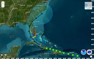
The initial motion is 290/14 kt. A turn toward the northwest and
north is expected during the next couple of days as the system moves
into a break in the subtropical ridge caused by a mid-latitude
trough over the Ohio Valley. This should be followed by recurvature
into the westerlies after about 60 h. On the forecast track, the
system is expected to move into the Straits of Florida and the
southeastern Gulf of Mexico on Saturday, followed by a motion near
the west coast of Florida Saturday night and Sunday. After that
time, the system should cross the northern Florida peninsula and
move over the Atlantic near or offshore of the southeastern coast of
the United States. The track guidance is in good agreement with
this scenario. However, since the forecast track is almost parallel
to the west coast of the Florida Peninsula and the southeast coast
of the U. S., only a small change in the track could lead to large
changes in which land areas receive any landfalls and the biggest
impacts.

Slow development is possible while the system is over Cuba, and the
system is likely to become a tropical depression soon after it
moves offshore. The environment over the Gulf of Mexico is quite
favorable for strengthening with light shear and very warm
sea-surface temperatures, so subsequent steady strengthening is
expected. The two biggest uncertainties in the intensity forecast
are how long the system will remain offshore of Florida and how
long it will take to consolidate. The system is likely to weaken
as it crosses Florida, with re-intensification likely over the
Atlantic.


Key Messages:

1. Heavy rainfall may result in flash and urban flooding across
portions of Florida and the Southeast this weekend through Wednesday
morning. Isolated river flooding will also be possible.

2. Tropical storm conditions are expected Saturday night within the
warning area in southwest Florida from East Cape Sable to Bonita
Beach where a Tropical Storm Warning has been issued. Tropical storm
conditions are possible in the Florida Keys on Saturday and along
the Florida west coast north of Bonita Beach to Aripeka Saturday
night and Sunday where a Tropical Storm Watch is in effect.

3. Coastal flooding is possible along portions of the west coast of
Florida over the weekend.

4. Interests elsewhere in Florida and along the southeast coast of
the United States from Georgia to North Carolina should monitor the
progress of this system.


FORECAST POSITIONS AND MAX WINDS

INIT 02/1500Z 20.9N 76.6W 25 KT 30 MPH...POTENTIAL TROP CYCLONE
12H 03/0000Z 21.7N 78.3W 25 KT 30 MPH...INLAND
24H 03/1200Z 23.3N 80.7W 30 KT 35 MPH...TROPICAL CYCLONE
36H 04/0000Z 25.1N 82.3W 35 KT 40 MPH
48H 04/1200Z 27.2N 83.0W 45 KT 50 MPH
60H 05/0000Z 29.2N 82.7W 55 KT 65 MPH...TROPICAL CYCLONE
72H 05/1200Z 30.7N 81.7W 40 KT 45 MPH...TROPICAL CYCLONE
96H 06/1200Z 32.0N 80.0W 40 KT 45 MPH...OVER WATER
120H 07/1200Z 33.6N 77.5W 50 KT 60 MPH

$$
Forecaster Beven


Anexos

  • PTC-4_20240802-15h_adv01.webp
    PTC-4_20240802-15h_adv01.webp
    90.9 KB · Visto: 13
  • 20242151610_GOES16-ABI-car-GEOCOLOR-2000x2000.webp
    20242151610_GOES16-ABI-car-GEOCOLOR-2000x2000.webp
    351.9 KB · Visto: 11
Última edição:
Continuo à espera das carradas de furacões que vinham aí... :sono:

Dois exemplos: 2005 acabou Julho na letra G, 2020 acabou Julho na letra I. :rolleyes: