Algum ar seco no quadrante sudoeste da circulação de Debby tem ajudado a impedir que se forme um centro fechado, um olho.
Isto pode atrasar um pouco a intensificação e a última previsão já não mostra os 80 nós a serem atingidos.
Mesmo assim, 75 nós (> 135 Km/h) ao entrar em terra.
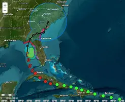
FORECAST POSITIONS AND MAX WINDS
INIT 04/2100Z 27.7N 84.4W 55 KT 65 MPH
12H 05/0600Z 29.1N 84.4W 75 KT 85 MPH
24H 05/1800Z 30.5N 83.8W 75 KT 85 MPH...INLAND
36H 06/0600Z 31.3N 83.0W 45 KT 50 MPH...INLAND
48H 06/1800Z 31.7N 82.1W 35 KT 40 MPH...INLAND
60H 07/0600Z 31.7N 81.1W 40 KT 45 MPH...INLAND
72H 07/1800Z 31.9N 80.5W 45 KT 50 MPH...OVER WATER
96H 08/1800Z 32.6N 80.1W 45 KT 50 MPH...INLAND
120H 09/1800Z 34.0N 79.5W 30 KT 35 MPH...INLAND
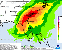
Debby está a ficar sem tempo para cumprir a previsão.
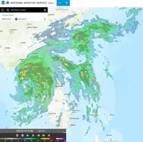
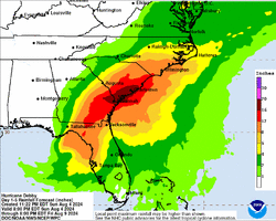
Na imagem de radar de há minutos o centro é mesmo a característica menos evidente, sobressaindo sim a longa linha de instabilidade que se prolonga e continua a ser gerada desde Cuba. É esta linha que tem produzindo a forte precipitação pela Florida, além de uma mais agressiva linha no lado norte da tempestade. Mais perto do centro observam-se três linhas que tentam fechar a circunferência mas a convecção aí tem pouca profundidade.
O que poderá vir a ser o olho está agora a esboçar-se e parece ter uma circulação já fechada mas com pouca actividade convectiva.

https://water.noaa.gov/