Previsão e Seguimento dos Ciclones no O. Índico - Temporada 2017/2018
- Thread starter Orion
- Data de início
-
O novo portal está no ar! Novos meteogramas, cartas, e mais. Mais informações neste tópico
Seguimento Meteorológico: Litoral Norte | Interior Norte e Centro | Litoral Centro | Sul | Açores e Madeira | Livre
Previsões: Curto e médio prazo: até 2 semanas | Longo prazo: mensal e sazonal (Regras e links úteis nos 1ºs posts)
Facebook | Avisos IPMA/Alertas ANEPC
You are using an out of date browser. It may not display this or other websites correctly.
You should upgrade or use an alternative browser.
You should upgrade or use an alternative browser.
luismeteo3
Furacão
India Meteorological Department
Tropical Cyclone Advisory #31 - 17:30 PM IST May 25 2018
EXTREMELY SEVERE CYCLONIC STORM MEKUNU (ARB03-2018)
========================================================
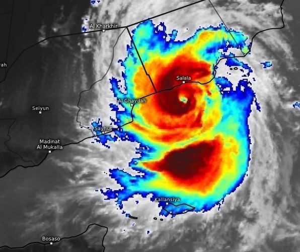
At 12:00 PM UTC, the Extremely Severe Cyclonic Storm Mekunu over west central Arabian Sea moved further north northwestwards with a speed of 12 km/h during past 06 hours, intensified slightly further and lay centered near 16.4N 54.1E, about 420 km nearly north of Socotra Islands and 70 km south of Salalah (Oman).
It is very likely to continue to move north northwestwards and cross southern Oman southeastern Yemen coasts close to Salalah during next 3 to 4 hours as an Extremely Severe Cyclonic Storm with sustained winds of 95 knots.
As per the satellite imagery, the intensity of the system is T5.0. The cloud shows eye pattern. Associated broken low/medium clouds with embedded intense to very intense convection lie over area between 12.5N & 19.0N and 51.0E to 57.0E deg. E. Minimum cloud top temperature is minus -93C.
3 minute sustained winds near the center is 95 knots with gusts of 105 knots. The state of the sea is phenomenal. Estimated central pressure of the very severe cyclonic storm is 962 hPa.
luismeteo3
Furacão
luismeteo3
Furacão
luismeteo3
Furacão
luismeteo3
Furacão
luismeteo3
Furacão
luismeteo3
Furacão
luismeteo3
Furacão
Partilhar:


