Seguimento Europa 2009

Estado
Fechado para novas mensagens.
Pedro, aqui na Austria esteve um dia algo frio, aliás tem estado assim recentemente devido a esta corrente de norte. O céu escuro, alguns aguaceiros, vento moderado e temperaturas entre os 14 e 19º
O Verão antecipado de Abril e Maio foi-se embora...
Mas nada de fora do vulgar.
 
Previsão do Estofex para Hoje dia 6 de Junho:


A level 2 was issued across N Italy ... E Austria ... N Balkans into S Poland mainly for tornadoes and severe wind gusts.

A level 1 surrounding the level 2 was issued across N and central Italy ... S Germany ... Alpine region ... N Balkans into S Poland mainly for tornadoes and severe wind gusts, and large hail.

SYNOPSIS

Complex pattern is developing over Europe, and the convective scenario is quite uncertain at the moment. Over portions of east-central Europe into the N Mediterranean, the situation may quickly evolve into a major severe thunderstorm outbreak.

The upper-air maps are mainly featuring an intense SWly upper flow with several imbedded vort maxima, most of which are transient in nature, rapidly lifting northeastwards into the Baltics. These features maintain and temporarily augment a SFC-low complex over western/central Europe.
One of the vort maxima imbedded in the SWly flow will lift across Germany, maintaining a wave cyclone centered over western Germany on Saturday afternoon. A warm front is anticipated to stretch from the low's center eastward into N Ukraine and the trailing cold front should stretch into the W Mediterranean at 12Z on Saturday.
Another vort max will dig into the northern Mediterranean late on Saturday/early Sunday morning.

DISCUSSION

... N Italy ... E Austria ... N Balkans ... E Czech Republic ... Slovakia ...

Main question this period will be whether or not instability can develop amidst extensive stratiform cloudiness/precipitation that is simulated across most of the warm-sector air mass.

Shear profiles will be quite intense with 25 m/s DLS and 10 m/s LLS, increasing to more than 15 m/s across the N Balkans into S Poland late in the day. GFS 18Z simulates quite extreme LLS after 18Z, locally exceeding 20 m/s. SRH1 will be maximized along the warm-frontal boundary, but even in the warm sector air, 200 J/kg should be common.

Precipitation and cloudiness should result in somewhat cool but nearly saturated boundary-layer air. The fact that the Saharan EML will remain S of the region of interest suggests that minimal capping will be in place, so that low-level kinematic and thermodynamic profiles should become very conducive to tornadogenesis. Numerical guidance suggests that CAPE will be present despite the existence of cloudiness/precip.

Currently, it seems that convective development will be quite messy, with a mixture of elevated/imbedded cells, and new development where breaks in the clouds occur. Of much concern is the strong low-level shear. Any SFC-based storm will have much potential of evolving into a tornadic supercell. Despite the anticipated weak instability, individual cells may become quite long-lived and an F3 tornado seems well within the scope of possibilities. In addition, severe wind gusts and marginally severe hail may occur.

An update will likely be necessary on Saturday, including a possible upgrade to LVL3, should widespread convection occur in the strongly-sheared regime over N Italy, the N balkans and E-central Europe.

... central Italy ...

Farther south, a sturdy cap is expected to obstruct any attempt of convective development during the day, but vigorous DCVA-forcing is expected ahead of the trough that moves into the Mediterranean late Saturday night/early Sunday morning. Though the strong cap should limit the coverage, an isolated storm or two may occur late in the night. Given strong ambient shear, supercells may be possible, posing mainly a large-hail and severe-wind threat.
 
Está um dia abafado aqui na Áustria com ventos algo fortes de sul.
Sigo com 24º de máxima e muita convexão na atmosfera, embora não é quente ainda.
Pressão nos 990s!
Vamos lá ver se dá alguma tempestade.
 
Previsão do Estofex para Hoje dia 7 de Junho:


A level 2 was issued for W Ukraine, SW Russa and SE Belarus mainly for strong tornadoes, large hail and damaging gusts.

A level 2 was issued for SE Austria, E Slovenia and SW Hungary mainly for damaging gusts and large hail.

A level 1 surrounding both level 2 areas was issued for Italy towards S Balkans, SW Russia, N Belarus, SE Poland and E Austria mainly for large hail and severe gusts.

A level 1 was issued for NE France, S Belgium and W Germany mainly for tornadoes and severe gusts.


SYNOPSIS

Between a ridge over the eastern Mediterranean and a large upper trough over central Europe, hot and moist air is advected into parts of eastern and southeastern Europe. Numerous imbedded vort-maxima will cross northwestern - central Europe and also parts of eastern Europe during the period. One of the dominant upper level disturbances should be located over eastern Poland on early Sunday morning and will translate northeastward into western Russia till Monday.

Another well-defined low pressure system over the East Atlantic is forecast to move southeastward towards the Iberian Peninsula, affecting NW Portugal in the second half of the forecast period.

A cold and more stable airmass over Scandinavia will be advected southward towards northern Germany during the period. Some thunderstorms should be possible in the vicinity of a weak cold front that will cross NE France and W Germany on Sunday afternoon.


DISCUSSION

...W Ukraine, S-central Belarus, SW Russia...

In the warm sector of a low pressure system located over eastern Poland, moderately unstable air with 500 to 1500 J/kg MLCAPE will be advectd into W Ukraine and Belarus. 00 UTC soundings from SW Ukraine show remnants of an EML which provides some weak capping in the western part of the level 2 area. Even near the center of the surface low, GFS predicts some low-end instability - almost uncapped but located in a very favorable kinematic environment. Model guidance hints at deep layer shear in order of 25 m/s in most parts of the Ukraine with very strong LLS and SRH1 / SRH3 increasing towards the warm front which extends from the S Baltic States into W Russia. Sufficient lift is provided by an upper vort-max that is forecast to cross the area of interest in the late morning / early afternoon hours.

Right now, remnants of the convective systems that developed yesterday evening over the N Balkans move across eastern Europe and the cloudiness at mid levels will hinder insolation which results in smaller MUCAPE than anticipated. Nevertheless, convective initiation is very likely as shown by simulated CAPE also in the vicinity of the stratiform precip regions in the level 2 area and almost every storm should be capable of producing large / very large hail and damaging gusts. The main fraction of storms that will develop is expected to be long-lived supercells that may also produce some possibly strong tornadoes. The threat of severe weather will continue until the late evening. Locally, excessive convective rainfall may lead to flash floods.


...extreme SE Austria, S Slovak Rep, Slovenia, Hungary...

In the wake of the intense low over Poland, moderate instability should be present after diurnal heating in the vicinity of a 35 m/s jet streak which stretches from Sardinia towards NE Hungary. Even though MLCAPE should be limited to values below 1 kJ/kg, any storm will profit from 30 - 35 m/s deep layer shear and organize into bowing line segments and supercells, capable of producing large hail and damaging gusts. A tornado cannot be ruled out but due to a lack of good LLS / SRH1 the tornado probability is significantly lower than in the level 2 area further downstream.

...large portions of Italy, including Sicily...

Very strong (25 - 35 m/s) DLS is forecast over Italy in a region with some hundred J/kg of CAPE. Some capping will still exist due to an EML advected from the N Sahara and initiation should depend on sufficient forcing. Vertical motion for ascent will have its origin in an upper vort-max over N Italy which is forecast to cross the affected region around midday. Storms should become well-organized multicells and supercells, capable of producing large hail and severe gusts. In the late afternoon / evening, the threat of severe weather will decrease as the boundary layer becomes more stable and almost all CAPE vanishes.

...NE France, W Germany...

Ahead of an approaching upper low over the Channel region, some hundred J/kg CAPE should be available. Deep layer shear should be best near the left exit region of a 30 m/s jet streak over NE France where strong QG forcing is forecast. Initiation will take place around midday and there will be some organized multicells and maybe also a few short-lived supercells. Rich BL moisture and about 10 m/s LLS will provide good conditions for a few tornadoes but strong tornadoes should be unlikely. Additionally, some marginally severe hail is possible and severe gusts due to downward transport of momentum are not ruled out as there are quite strong winds in the mid and lower levels.
 
Previsão do Estofex para Hoje dia 8 de Junho:


A level 2 was issued for parts of SW Russia, central Ukraine, parts of Moldova and Romania mainly for large hail, excessive rainfall, and to a lesser extent for wind gusts.

A level 1 was issued for a larger area including parts of Bulgaria, mainly for large hail, excessive rainfall, and to a lesser extent for wind gusts.

A level 1 was issued for parts of France mainly for tornadoes.

SYNOPSIS

Monday at 0600 UTC... a broad west to southwesterly jet stream is located over Europe. During the forecast period, a vorticity maximum over northern Germany and Denmark translates ENEward to the St. Petersburg area, and another vorticity maximum near Cape Finisterre translates to NWern France. Downstream of these features, a weak trough stretching from W Russia across Belarus to the central Balkans moves eastward rather slowly. The lower tropospheric temperature gradient across the jet is rather weak, with a well-defined elevated mixed layer only being present across the eastern Balkans and into the Ukraine

DISCUSSION

SW Russia, central Ukraine, Moldova, Romania, Bulgaria

Convergence ahead of the east-ward moving mid/upper-level trough causes moisture to pool under the elevated mixed layer that is in place across the eastern 1/3 of the Balkan Peninsula, and central parts of the Ukraine. The result is that substantial MLCAPE, up to around 2000 J/kg should develop as the moist air is diurnally warmed. Models suggest that convection will initiate in various places. Given that 0-3 km shear will be near 15 m/s, supercells will be possible, in addition to well-organized multicells. These will have a threat of producing large or even very large hail, and may also cause severe wind gusts. As storms will probably move mostly paralell to the low-level convergence zone, training of storm cells is probable, and excessive rainfall is warned for. Storms will weaken during the late evening and night.

France...

Ahead of the approaching vorticity maximum and an associated surface low over the Bay of Biscay, the south- to southwesterly low-level flow will intensify to around 15 m/s at 850 hPa. Scattered convective storms are expected to develop as a result of diurnal heating. A few factors favourable for (weak) tornadoes appear to become spatially and temporally collocated across the level 1 area. These are i) a moist low-level air-mass with forecast dew point temperatures around 14-15 C ii) the development of a W-E oriented warm front iiI) sufficient low-level and deep-layer shear for storm rotation. Together these factors appear to be sufficient for the issuance of a level 1, despite the fact that CAPE stays rather low. To put it shortly, a few tornadoes may occur, most likely near the warm front or other boundaries. Some small hail is possible too. The storms will quickly weaken after sunset.

Baltic States, NW Belarus...

Ahead of the vorticitiy maximum over northern Germany, which translates ENE-ward, some instabiltiy will probably form. Deep-layer and low-level may be marginally sufficient to support some updraught rotation. However, only a few storms are expected to form during daytime, and the shear is marginal enough for a level 1 for a tornado threat not to be required.
 
Vaga de calor no sudeste da Europa

Temperaturas máximas no Domingo, dia 7 de Junho:

1 Rousse (Bulgaria) 39.6 °C
2 Pleven (Bulgaria) 37.5 °C
3 Silistra (Bulgaria) 37.5 °C
4 Calarasi (Romania) 37.2 °C
5 Lovetch (Bulgaria) 37.0 °C
6 Aydin (Turkey) 36.5 °C
7 Veliko Tarnovo (Bulgaria) 36.5 °C
8 Larissa Airport (Greece) 36.2 °C
9 Bodrum (Turkey) 36.1 °C
10 Antalya (Turkey) 36.0 °C

Fonte: OGIMET
 
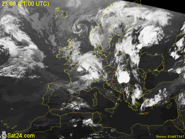
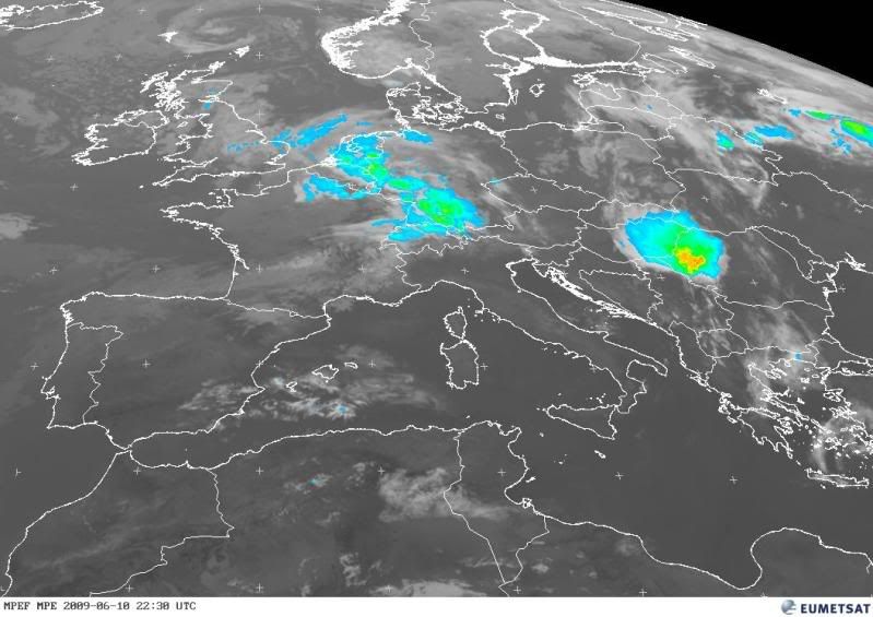
Na Europa de leste, desenvolveu-se há instantes uma enorme célula.

imageashx-18.gif


EUMETSAT_MSG_MPE-centralEurope.jpg


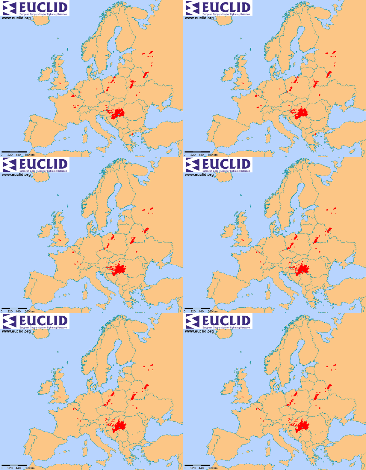
Descargas eléctricas:

euclid_last_lightnings-1.gif


Como o aparato prometia ser grande, Eu, o Gilmet, o Henrique, o Saul Monteiro, o teles e o miguel resolvemos fazer uma espécie de caçada virtual.
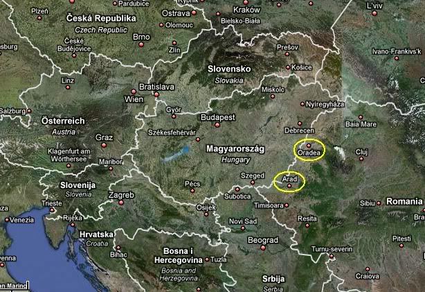
Andámos em busca de webcams na zona da Roménia e da Hungria, e conseguimos encontrar duas a transmitir em directo, nas cidades de Arad e Oradea.

Mapa-1.jpg


Digamos que ainda conseguimos regalar a vista. :D

Segue-se de seguida alguns print screens das imagens que conseguimos captar.
 
Algumas imagens recolhidas há pouco, das Webcams Online do Noroeste da Roménia.


ORADEA
webcamromniacomposio2.png


(Um animal voador resolveu acamar-se mesmo por cima da Webcam. Pedimos desculpa.:D)


ARAD
webcamromnia2composio2.png
 
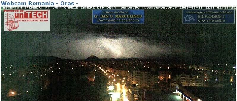
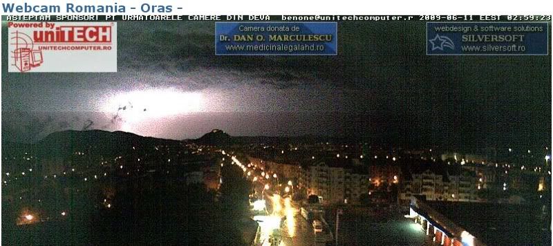
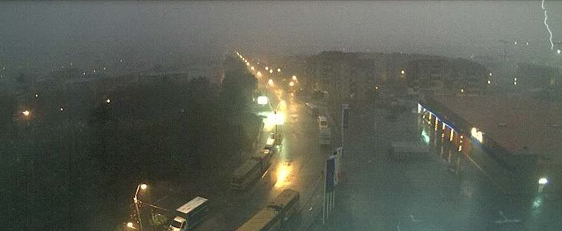
Mais duas combinações de imagens obtidas na Webcam de Oras, na Roménia Oeste.

webcamromnia4combinao4.png


Os melhores raios da noite.:D

webcamromnia4combinao3.png


O núcleo de instabilidade desloca-se agora para o centro da Roménia, no sentido leste.


Imagem de radar da precipitação:
 
Olá a todos,

Aqui em Viena, a células da Roménia passou mesmo cá em cima, mas ainda estava em formação. Tinha um aspecto algo escuro e convectivo e foi dando uns aguaceiros moderados a meio do dia, enquanto o ar estava mesmo abafado perto dos 25º.

Aliás, há cerca de já uns vários dias seguidos que tem sido assim: céu muito nublado, muita convexão e ar abafado, mas os aguaceiros não tem sido nada de outro mundo.

Hoje ao contrário veio um belo dia de sol e a partir de amanhã as temperaturas prometem chegar aos 30º e até ultrapassar, antes de voltar as trovoadas que desta vez creio que vão ser finalmente fortes. Já houve cerca de uma dezena de trovoadas este ano, mas nenhuma ainda digna do poder que por vezes costumam ter aqui na Europa Central em pleno verão.

Ainda me vai na memórias as tempestades fantásticas do último verão aqui!
Hoje: 13º manhã (fresca), 23º tarde agradável, 19º à noite (muito agradável!)

Fui agora ver a webcam de Dave, e só me dá sol e poucas nuvens...:lol:
 
Estado
Fechado para novas mensagens.