Seguimento Europa 2016
- Thread starter Orion
- Data de início
-
O novo portal está no ar! Novos meteogramas, cartas, e mais. Mais informações neste tópico
Seguimento Meteorológico: Litoral Norte | Interior Norte e Centro | Litoral Centro | Sul | Açores e Madeira | Livre
Previsões: Curto e médio prazo: até 2 semanas | Longo prazo: mensal e sazonal (Regras e links úteis nos 1ºs posts)
Facebook | Avisos IPMA/Alertas ANEPC
You are using an out of date browser. It may not display this or other websites correctly.
You should upgrade or use an alternative browser.
You should upgrade or use an alternative browser.
- Estado
- Fechado para novas mensagens.
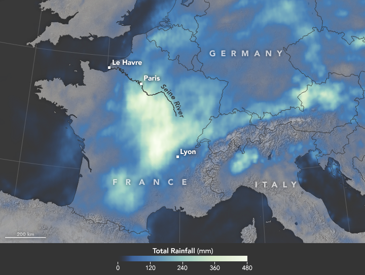
In June 2016, a slow-moving weather system unleashed several days of heavy downpours on western Europe, pushing the Seine River to heights not seen in 34 years. With the Seine’s water levels 6.1 meters (20 feet) above normal in Paris, flood waters knocked out electricity for thousands of people, interrupted road and rail traffic, shut down schools, and caused an estimated 1 billion euros of damage. During the worst of the flooding, the world’s most visited museum, the Louvre, closed as employees scrambled to move artwork out of basement areas that were at risk of flooding.
The map above depicts satellite-based measurements of rainfall over western Europe from May 22 to June 6, as compiled by NASA. These rainfall totals are regional, remotely-sensed estimates, and local amounts can be significantly higher when measured from the ground. Much of the rain—more than 400 millimeters (16 inches) in some areas—fell in central France within the Seine’s drainage basin.
The data come from the Integrated Multi-Satellite Retrievals for GPM (IMERG), a product of the Global Precipitation Measurement mission. IMERG pulls together precipitation estimates from passive microwave and infrared sensors on several satellites, as well as monthly surface precipitation gauge data, to provide precipitation estimates between 60 degrees North and South latitude. The GPM satellite is the core of a rainfall observatory that includes measurements from NASA, the Japan Aerospace Exploration Agency, and five other national and international partners.
The rains were fueled by a blocking pattern in the jet stream. According to the Weather Channel, an area of low pressure remained nearly stationary for days, sustaining persistent downpours in the region.
- References and Further Reading
- BBC (2016, June 3) France floods: Louvre to close as Seine rises further. Accessed June 7, 2016.
- The Guardian (2016, June 5) France floods ‘caused one billion euros worth of damage’. Accessed June 7, 2016.
- The Weather Channel (2016, June 1) Here’s What Caused the Deadly Floods in Germany and France. Accessed June 7, 2016.
- Reuters (2016, June 3) Paris museums move art works as flood waters rise. Accessed June 7, 2016.
Instrument(s):
GPM
http://earthobservatory.nasa.gov/IOTD/view.php?id=88157
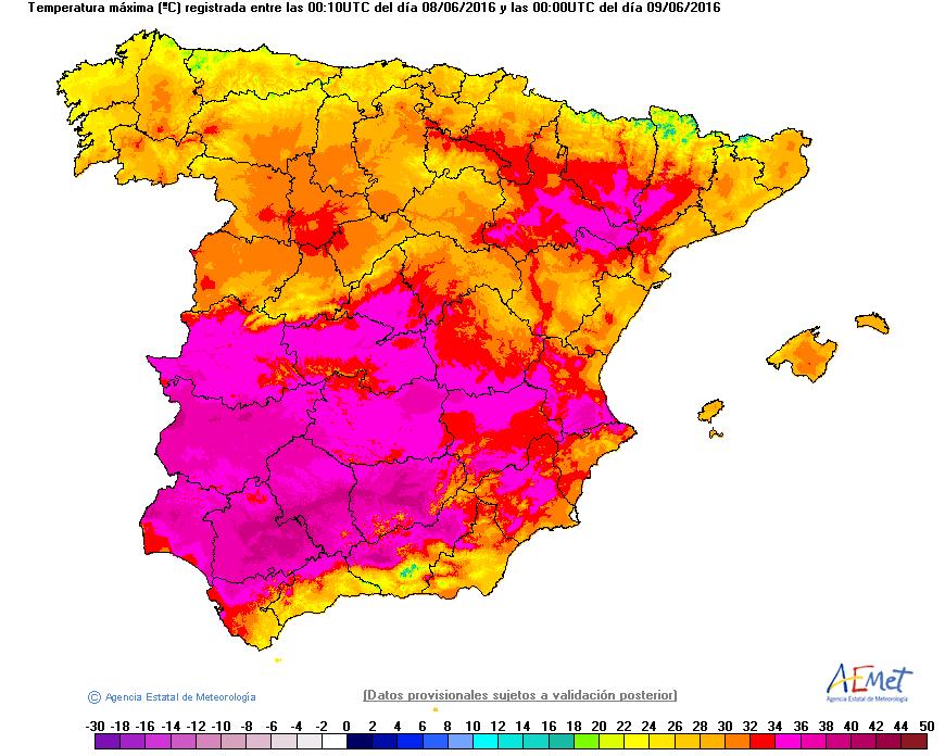
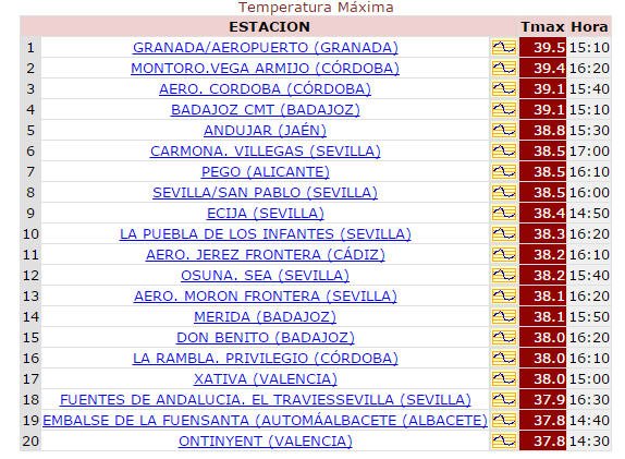
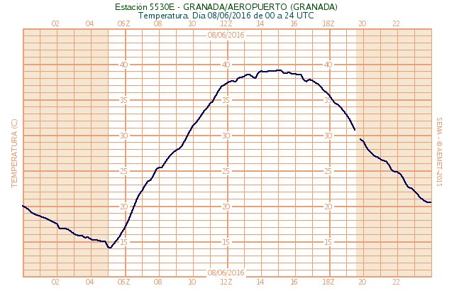
Ayer mucho calor en puntos del sur y suroeste peninsular, donde se superaron en bastantes zonas los 34º C. Máxima de la red de estaciones de AEMET en Granada con 39,5 ºC:


Que braseiro na vizinha Espanha.
Top máximas de hoje.

Top máximas de hoje.

Que braseiro na vizinha Espanha.
Top máximas de hoje.

En realidad sólo una parte de España, víctima en muchos casos del foehn de los vientos del oeste-noroeste.
En el resto del país las máximas de ayer fueron así:
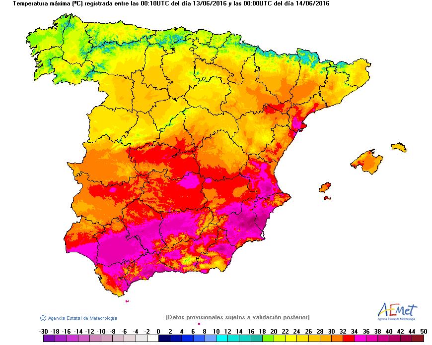
Lo que siempre comentamos, la enorme diversidad ibérica. Parecen varias zonas de Europa en una sola

Y hoy más de lo mismo:
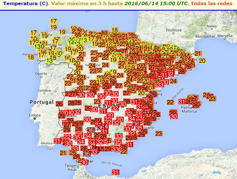
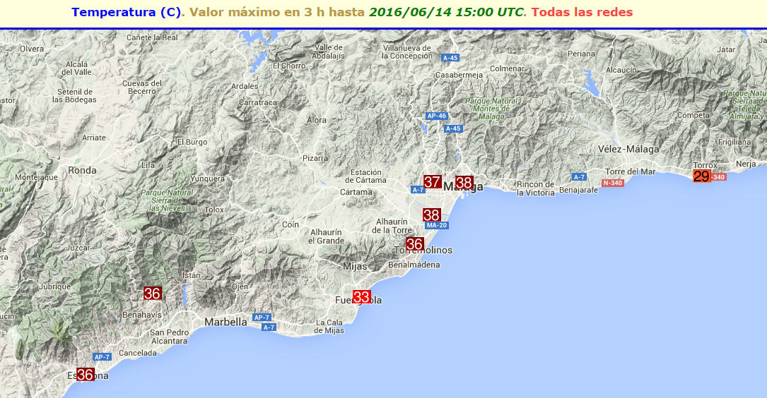
En cambio en Málaga por efecto foehn (consecuencia del viento terral)...


Y para el miércoles/jueves nieve en las montañas de la mitad norte peninsular. Bonito contraste
Última edição:
Efectivamente como decíamos ayer nevando y cuajando en zonas montañosas de la mitad norte ibérica. Webcam de Collado Jermoso (León) a unos 2000 metros:

Imagen de su Facebook. Tenían pensado montar la terraza para el verano pero ha habido que esperar

Fuente: https://m.facebook.com/refugio.colladojermoso/

Imagen de su Facebook. Tenían pensado montar la terraza para el verano pero ha habido que esperar


Fuente: https://m.facebook.com/refugio.colladojermoso/
En la vertiente norte de la Cordillera Cantábrica la nevada ha sido también consistente, como podemos comprobar en este vídeo del Refugio Urriellu (Asturias), a 1950 metros, que han compartido en su Facebook:
Y ha seguido nevando. Vídeo de hace unas 3 horas del Facebook de Collado Jermoso con la nevada de hoy:
Entre 10 y 11 centímetros acumulados en el Refugio había hace 1 hora:
Imagen de ahora mismo de la webcam situada en Collado Jermoso (León, 2050 m):

Edito para añadir que la cota de nieve cuajada durante este episodio se ha situado aproximadamente en aquella zona sobre los 1750 metros. Probablemente las nevadas puedan extenderse por allí hasta el próximo domingo.
Y ha seguido nevando. Vídeo de hace unas 3 horas del Facebook de Collado Jermoso con la nevada de hoy:
Entre 10 y 11 centímetros acumulados en el Refugio había hace 1 hora:
Imagen de ahora mismo de la webcam situada en Collado Jermoso (León, 2050 m):

Edito para añadir que la cota de nieve cuajada durante este episodio se ha situado aproximadamente en aquella zona sobre los 1750 metros. Probablemente las nevadas puedan extenderse por allí hasta el próximo domingo.
Última edição:
irpsit
Cumulonimbus
Hoje pode haver festa por estes lados na Europa.
O estofex mete nível 2 com alguma seriedade entre o leste da Suíca e o sudoeste da Polónia, incluindo Republica Checa.
Aqui na Austria a maxima atingiu 29°C e agora estao 26°C e tem chovido bem desde há meia hora, mesmo tropical, e o vento sopra forte de sul-sudoeste (fohn), aquecido por passar nos Alpes. Mas a convexao ainda assim nao está muito forte.
Apanhámos uma pequena célula, mas há uma supercélula na fronteira entre Suíca e Austria e algumas células com chuva intensa na Rep Checa.
Joaopaulo
Cumulonimbus
Imagem satélite, forte convecção na zona oeste/central e leste da Europa


luismeteo3
Furacão
The highest level of alert weather for Poland 4 dead today
Violent storms swept across the Polish . Landscape after the passage element is frightening. There are fatalities . Unfortunately, this is not the end . Institute of Meteorology and Water Management issued a warning - first, second and third degree . Projected strong thunderstorms with hail , wind and intense rain can be very destructive consequences.
more in link use translator
https://pogoda.interia.pl/wiadomosci/news-najwyzszy-stopien-alertu-pogodowego-dla-polski,nId,2221210
irpsit
Cumulonimbus
Trovoada da brava aqui na parte norte da Áustria.
A mais intensa da época. Uma célula em formacao resultou na chuva mais intensa do ano e um ritmo de 3 trovoes audiveis por segundo, um constante rugir há já 30minutos!!!
Granizo foi pequeno, durante uns minutos, até 0.5cm. Chuva foi torrencial furante uns 5 a 10 minutos mas continua a chuva intensa há mais de meia hora.
Também foi dado o nível 3 pelo Estofex para a Europa de leste, mais uma vez. Já ontem foi violento na parte leste da Europa.
Tem sido um Junho cheio de convexao na Europa. Nao há um dia de descanso. Só me recordo de um dia sem chuva.
Ontem e anteontem foi muito tropical por cá também... chuva, calor, ar abafado, vento...
Vou continuar o ver o show...
Uma brutalidade. O tecto da nuvem é bem elevado também, quando comecou a chover.
Células pequenas fazem por vezes surpresas mais interessantes do que supercélulas que já duram há horas...
Día con tormentas severas de notable intensidad en Baleares y su entorno.
Captura matinal del radar donde se aprecian pixeles morados de máxima intensidad. Esta circunstancia ha ocurrido de forma habitual durante toda la mañana:

Aparición de supercélulas en la zona como vemos en esta animación del radar regional balear. En ella se pueden distinguir dos supercélulas:
Una de ellas ha pasado junto a la zona norte de Menorca (cerca de Fornells), donde un amigo ha podido capturar este pequeño tornado originado por dicha supercélula:

En Cataluña también tormentas severas con nieve en zonas de montaña como ha ocurrido en el área de Ensija (provincia de Barcelona):
Destacar también la actividad tormentosa que se extiende por muchas zonas europeas. Captura de Blitzortung de las 12:35 UTC:

Edit: Ejemplo del crecimiento de alguna de estas tormentas baleares en las cercanías de Palma de Mallorca:

Fuente: https://twitter.com/soychubasco
Captura matinal del radar donde se aprecian pixeles morados de máxima intensidad. Esta circunstancia ha ocurrido de forma habitual durante toda la mañana:

Aparición de supercélulas en la zona como vemos en esta animación del radar regional balear. En ella se pueden distinguir dos supercélulas:
Una de ellas ha pasado junto a la zona norte de Menorca (cerca de Fornells), donde un amigo ha podido capturar este pequeño tornado originado por dicha supercélula:

En Cataluña también tormentas severas con nieve en zonas de montaña como ha ocurrido en el área de Ensija (provincia de Barcelona):
Destacar también la actividad tormentosa que se extiende por muchas zonas europeas. Captura de Blitzortung de las 12:35 UTC:

Edit: Ejemplo del crecimiento de alguna de estas tormentas baleares en las cercanías de Palma de Mallorca:

Fuente: https://twitter.com/soychubasco
Última edição:
Muchísimo calor hoy en la zona del Egeo, llegándose a los 42 ºC en puntos de Grecia y Turquía:


Fortes tormentas na Roménia, Macedónia e Ucrânia:

Os romenos também têm imagens de radar com mapa dinâmico:
http://www.inmh.ro/images/radarg/index.radar.php

Os romenos também têm imagens de radar com mapa dinâmico:
http://www.inmh.ro/images/radarg/index.radar.php
- Estado
- Fechado para novas mensagens.
Partilhar:


