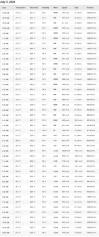
Beryl fez landfall em princípio a norte de Tulum, devido a mais uma pequena viragem de rumo pouco antes, desta vez para a direita. O olho já não estava distinto nas imagens de satélite, e mesmo o voo de reconhecimento não encontrou uma estrutura que se pudesse chamar parede do olho.
Mas no radar de Cancún ainda apareciam, já em terra, ecos que denunciavam o centro do furacão:

"
000
WTNT42 KNHC 050850
TCDAT2
Hurricane Beryl Discussion Number 27
NWS National Hurricane Center Miami FL AL022024
400 AM CDT Fri Jul 05 2024
Beryl is nearing landfall in the Yucatan Peninsula this morning.
After unexpectedly intensifying some last night against continued
shear, Beryl has plateaued or filled a bit. The last few fixes from
the Air Force Reserve Reconnaissance mission indicated the pressure
rose 9 mb while the peak 700-mb wind in the final NE leg out of
Beryl were down to 102 kt with lower SFMR values. In addition, the
aircraft was no longer reporting an eyewall and the presentation of
Beryl's inner core from radar out of Cancun, Mexico has become more
degraded. On satellite, the hurricane has also become more
amorphous, with a lack of an eye signature on infrared imagery, and
evidence of southerly shear continuing to undercut its outflow. The
initial intensity this advisory was adjusted to 95 kt, which is
still higher than the satellite intensity estimates, out of respect
of the earlier recon data.
The hurricane appears to now be moving more west-northwestward this
morning, estimated at 285/13 kt. Beryl should maintain this
west-northwest heading as it crosses the Yucatan Peninsula today and
emerges over the Gulf of Mexico by tonight. "
O aspecto era este às 9:35 utc, pouco antes do que se pode considerar landfall:

"
000
WTNT42 KNHC 051451
TCDAT2
Hurricane Beryl Discussion Number 28
NWS National Hurricane Center Miami FL AL022024
1000 AM CDT Fri Jul 05 2024
The center of Beryl made landfall on the Yucatan Peninsula of
Mexico just northeast of Tulum at about 11Z. The landfall intensity
is somewhat uncertain, but surface observations suggest the central
pressure rose into the 977-980 mb range before landfall. The
cyclone is now weakening as it moves farther inland, and the
initial intensity is reduced to 75 kt.
The initial motion is now 290/14 kt. "
Atravessa a península de Yucatan nesta altura, com aspecto bastante diminuído mas ainda furacão (Cat.1).

Mas no radar de Cancún ainda apareciam, já em terra, ecos que denunciavam o centro do furacão:
"
000
WTNT42 KNHC 050850
TCDAT2
Hurricane Beryl Discussion Number 27
NWS National Hurricane Center Miami FL AL022024
400 AM CDT Fri Jul 05 2024
Beryl is nearing landfall in the Yucatan Peninsula this morning.
After unexpectedly intensifying some last night against continued
shear, Beryl has plateaued or filled a bit. The last few fixes from
the Air Force Reserve Reconnaissance mission indicated the pressure
rose 9 mb while the peak 700-mb wind in the final NE leg out of
Beryl were down to 102 kt with lower SFMR values. In addition, the
aircraft was no longer reporting an eyewall and the presentation of
Beryl's inner core from radar out of Cancun, Mexico has become more
degraded. On satellite, the hurricane has also become more
amorphous, with a lack of an eye signature on infrared imagery, and
evidence of southerly shear continuing to undercut its outflow. The
initial intensity this advisory was adjusted to 95 kt, which is
still higher than the satellite intensity estimates, out of respect
of the earlier recon data.
The hurricane appears to now be moving more west-northwestward this
morning, estimated at 285/13 kt. Beryl should maintain this
west-northwest heading as it crosses the Yucatan Peninsula today and
emerges over the Gulf of Mexico by tonight. "
O aspecto era este às 9:35 utc, pouco antes do que se pode considerar landfall:
"
000
WTNT42 KNHC 051451
TCDAT2
Hurricane Beryl Discussion Number 28
NWS National Hurricane Center Miami FL AL022024
1000 AM CDT Fri Jul 05 2024
The center of Beryl made landfall on the Yucatan Peninsula of
Mexico just northeast of Tulum at about 11Z. The landfall intensity
is somewhat uncertain, but surface observations suggest the central
pressure rose into the 977-980 mb range before landfall. The
cyclone is now weakening as it moves farther inland, and the
initial intensity is reduced to 75 kt.
The initial motion is now 290/14 kt. "
Atravessa a península de Yucatan nesta altura, com aspecto bastante diminuído mas ainda furacão (Cat.1).