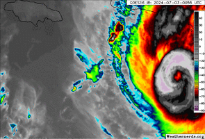
Cada vez mais a trajectória deriva para norte, já passa sobre a costa sul da Jamaica e ainda com categoria 3. 

000
WTNT42 KNHC 021441
TCDAT2
Hurricane Beryl Discussion Number 16
NWS National Hurricane Center Miami FL AL022024
1100 AM AST Tue Jul 02 2024
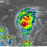
Data from NOAA and Air Force Reserve Hurricane Hunter aircraft,
along with satellite imagery, suggest that Beryl peaked in
intensity around 10-12Z. Since then, the aircraft data show
that the central pressure has slowly risen to near 938 mb and that
the maximum flight-level winds have decreased a little. In addition,
satellite imagery indicates some decay in the cloud pattern. Based
on the aircraft data, the initial intensity is set at 140 kt.
The initial motion is a quick 285/19 kt. A strong subtropical
ridge centered over the southern United States will continue to
steer Beryl west-northwestward to westward across the central and
northwestern Caribbean for the next few days, and this motion
should bring the center near Jamaica in 24-36 h and the Yucatan
Peninsula of Mexico around 72 h. After that, there is a significant
spread in the track guidance when Beryl emerges into the
southwestern Gulf of Mexico, due mainly to model differences in the
strength and location of a break in the subtropical ridge over the
southern United States. Thus, there remains considerable
uncertainty in the track forecast during the latter part of the
forecast period.
The intensity forecast also remains uncertain. There is general
agreement in the guidance that Beryl should weaken due to westerly
shear and possible land interaction as it approaches Jamaica.
However, some of the guidance forecasts a weakening rate that looks
somewhat unlikely given the current intensity and structure of the
hurricane. The new intensity forecast calls for Beryl to still be a
major hurricane when it passes near Jamaica and still be a hurricane
when it reaches the Yucatan Peninsula, and this portion of the
forecast lies near the upper end of the intensity guidance. There
is considerable spread in the intensity guidance when Beryl emerges
over the Gulf of Mexico, partly due to uncertainties as to how long
the storm will remain over water and partly due to uncertainties in
how the cyclone will interact with an upper-level trough to the
west. This part of the forecast lies in the middle of the
spread-out intensity guidance.
Key Messages:
1. Beryl is forecast to remain a powerful hurricane as it moves
across the Caribbean Sea later this week. A Hurricane Warning is in
effect for Jamaica, where hurricane conditions are expected on
Wednesday. A Tropical Storm Warning is also in effect for the south
coast of Hispaniola, and a Hurricane Watch is in effect for all
of the Cayman Islands and the southwestern peninsula of Haiti.
2. Heavy rainfall and flash flooding are likely over much of Jamaica
and southern Hispaniola through late Wednesday.
3. Interests in Belize, the Yucatan Peninsula, Cuba, and the
southwestern Gulf of Mexico should monitor the progress of Beryl.
Additional watches and warnings will likely be required later today
or Wednesday.
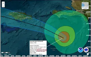
FORECAST POSITIONS AND MAX WINDS
INIT 02/1500Z 15.3N 68.9W 140 KT 160 MPH
12H 03/0000Z 16.2N 71.6W 135 KT 155 MPH
24H 03/1200Z 17.2N 75.0W 120 KT 140 MPH
36H 04/0000Z 18.1N 78.5W 105 KT 120 MPH
48H 04/1200Z 18.8N 82.0W 90 KT 105 MPH
60H 05/0000Z 19.3N 85.4W 80 KT 90 MPH
72H 05/1200Z 20.0N 88.2W 65 KT 75 MPH...INLAND
96H 06/1200Z 22.0N 93.0W 55 KT 65 MPH...OVER WATER
120H 07/1200Z 24.0N 96.4W 55 KT 65 MPH
$$
Forecaster Beven
000
WTNT42 KNHC 021441
TCDAT2
Hurricane Beryl Discussion Number 16
NWS National Hurricane Center Miami FL AL022024
1100 AM AST Tue Jul 02 2024
Data from NOAA and Air Force Reserve Hurricane Hunter aircraft,
along with satellite imagery, suggest that Beryl peaked in
intensity around 10-12Z. Since then, the aircraft data show
that the central pressure has slowly risen to near 938 mb and that
the maximum flight-level winds have decreased a little. In addition,
satellite imagery indicates some decay in the cloud pattern. Based
on the aircraft data, the initial intensity is set at 140 kt.
The initial motion is a quick 285/19 kt. A strong subtropical
ridge centered over the southern United States will continue to
steer Beryl west-northwestward to westward across the central and
northwestern Caribbean for the next few days, and this motion
should bring the center near Jamaica in 24-36 h and the Yucatan
Peninsula of Mexico around 72 h. After that, there is a significant
spread in the track guidance when Beryl emerges into the
southwestern Gulf of Mexico, due mainly to model differences in the
strength and location of a break in the subtropical ridge over the
southern United States. Thus, there remains considerable
uncertainty in the track forecast during the latter part of the
forecast period.
The intensity forecast also remains uncertain. There is general
agreement in the guidance that Beryl should weaken due to westerly
shear and possible land interaction as it approaches Jamaica.
However, some of the guidance forecasts a weakening rate that looks
somewhat unlikely given the current intensity and structure of the
hurricane. The new intensity forecast calls for Beryl to still be a
major hurricane when it passes near Jamaica and still be a hurricane
when it reaches the Yucatan Peninsula, and this portion of the
forecast lies near the upper end of the intensity guidance. There
is considerable spread in the intensity guidance when Beryl emerges
over the Gulf of Mexico, partly due to uncertainties as to how long
the storm will remain over water and partly due to uncertainties in
how the cyclone will interact with an upper-level trough to the
west. This part of the forecast lies in the middle of the
spread-out intensity guidance.
Key Messages:
1. Beryl is forecast to remain a powerful hurricane as it moves
across the Caribbean Sea later this week. A Hurricane Warning is in
effect for Jamaica, where hurricane conditions are expected on
Wednesday. A Tropical Storm Warning is also in effect for the south
coast of Hispaniola, and a Hurricane Watch is in effect for all
of the Cayman Islands and the southwestern peninsula of Haiti.
2. Heavy rainfall and flash flooding are likely over much of Jamaica
and southern Hispaniola through late Wednesday.
3. Interests in Belize, the Yucatan Peninsula, Cuba, and the
southwestern Gulf of Mexico should monitor the progress of Beryl.
Additional watches and warnings will likely be required later today
or Wednesday.
FORECAST POSITIONS AND MAX WINDS
INIT 02/1500Z 15.3N 68.9W 140 KT 160 MPH
12H 03/0000Z 16.2N 71.6W 135 KT 155 MPH
24H 03/1200Z 17.2N 75.0W 120 KT 140 MPH
36H 04/0000Z 18.1N 78.5W 105 KT 120 MPH
48H 04/1200Z 18.8N 82.0W 90 KT 105 MPH
60H 05/0000Z 19.3N 85.4W 80 KT 90 MPH
72H 05/1200Z 20.0N 88.2W 65 KT 75 MPH...INLAND
96H 06/1200Z 22.0N 93.0W 55 KT 65 MPH...OVER WATER
120H 07/1200Z 24.0N 96.4W 55 KT 65 MPH
$$
Forecaster Beven