BULLETIN
Hurricane Beryl Advisory Number 21
NWS National Hurricane Center Miami FL AL022024
500 PM EDT Wed Jul 03 2024
...EYEWALL OF BERYL BRUSHING THE SOUTH COAST OF JAMAICA
WITH HURRICANE CONDITIONS OCCURRING...
...THE HURRICANE IS EXPECTED TO APPROACH THE CAYMAN ISLANDS TONIGHT
INTO THURSDAY AND THE YUCATAN PENINSULA THURSDAY NIGHT...
SUMMARY OF 500 PM EDT...2100 UTC...INFORMATION
----------------------------------------------
LOCATION...17.5N 77.6W
ABOUT 65 MI...100 KM WSW OF KINGSTON JAMAICA
ABOUT 265 MI...430 KM ESE OF GRAND CAYMAN
MAXIMUM SUSTAINED WINDS...140 MPH...220 KM/H
PRESENT MOVEMENT...WNW OR 285 DEGREES AT 20 MPH...31 KM/H
MINIMUM CENTRAL PRESSURE...959 MB...28.32 INCHES
Sem landfall, mas a parede norte do olho deste Cat.4 a devastar a costa Sul/SSE da Jamaica.
Não houve inflexão suficiente da trajectória para W; e os ventos máximos continuam a classificar Beryl na categoria 4.
A entrada da parede norte do olho de Beryl pela costa sul da Jamaica, ver imagem a imagem para localizar:
19:25 - a nova parede do olho inicia a passagem em Portland Point, talvez o momento em que o olho esteve mais perto de fazer landfall;
19:45 - esta linha de topos mais elevados e frios progride para norte e atinge Peak Bay enquanto chega a Portland e Salt Savannah;
20:35 - aquela linha estende-se desde Hellshire para Oeste até Aligator Pond;
21:15 - nova explosão de convecção na parede norte do olho atinge os -90ºC nos topos, sobre a costa desde Rocky Point até Flagaman;
22:05 - esta maior massa de topos mais elevados continua a progredir para W e NW até atingir Black River;
23:25 - no final desta sequência de imagens, a convecção mais profunda está sobre Savanna La Mar, quase no extremo oeste da ilha; o olho a sul manteve-se sempre sobre a água e ainda é localizável.
No limite inferior de Cat.4, 960 hPa, ventos máximos à superfície de 209 Km/h, mas...
"Velocidade do vento no topo e nas encostas de barlavento de colinas e montanhas são frequentemente até 30 por cento mais fortes do que os ventos junto à superfície indicados neste aviso, e em alguns locais elevados pode ser ainda maior."
000
WTNT32 KNHC 032353
TCPAT2
BULLETIN
Hurricane Beryl Intermediate Advisory Number 21A
NWS National Hurricane Center Miami FL AL022024
800 PM EDT Wed Jul 03 2024
...EYEWALL OF EXTREMELY DANGEROUS CATEGORY 4 BERYL MOVING NEAR
SOUTHWESTERN JAMAICA...
...EXPECTED TO APPROACH THE CAYMAN ISLANDS LATER TONIGHT...
SUMMARY OF 800 PM EDT...0000 UTC...INFORMATION
----------------------------------------------
LOCATION...17.8N 78.3W
ABOUT 100 MI...160 KM W OF KINGSTON JAMAICA
ABOUT 215 MI...350 KM ESE OF GRAND CAYMAN
MAXIMUM SUSTAINED WINDS...130 MPH...215 KM/H
PRESENT MOVEMENT...WNW OR 285 DEGREES AT 20 MPH...31 KM/H
MINIMUM CENTRAL PRESSURE...960 MB...28.35 INCHES
WATCHES AND WARNINGS
--------------------
CHANGES WITH THIS ADVISORY:
The government of Mexico has upgraded the Tropical Storm Watch to a
Tropical Storm Warning from Cabo Catoche to Progresso in the
Yucatan Peninsula.
SUMMARY OF WATCHES AND WARNINGS IN EFFECT:
A Hurricane Warning is in effect for...
* Jamaica
* Grand Cayman
* Little Cayman and Cayman Brac
* The coast of the Yucatan Peninsula of Mexico from Puerto Costa
Maya to Cancun
A Hurricane Watch is in effect for...
* The coast of the Yucatan Peninsula of Mexico south of Puerto
Costa Maya to Chetumal
* The coast of the Yucatan Peninsula of Mexico north of Cancun to
Cabo Catoche
A Tropical Storm Warning is in effect for...
* The coast of the Yucatan Peninsula of Mexico south of Puerto
Costa Maya to Chetumal
* The coast of the Yucatan Peninsula of Mexico north of Cancun to
Progresso
A Tropical Storm Watch is in effect for...
* Coast of Belize from south of Chetumal to Belize City
* The coast of the Yucatan Peninsula of Mexico west of Progresso to
Campeche
A Hurricane Warning means that hurricane conditions are expected
somewhere within the warning area. Preparations to protect life
and property should be rushed to completion.
A Tropical Storm Warning means that tropical storm conditions are
expected somewhere within the warning area within 36 hours.
A Hurricane Watch means that hurricane conditions are possible
within the watch area, generally within 48 hours.
A Tropical Storm Watch means that tropical storm conditions are
possible within the watch area, generally within 48 hours.
Interests elsewhere in the northwestern Caribbean Sea and the
western Gulf of Mexico, including southern Texas, should closely
monitor the progress of Beryl.
For storm information specific to your area, please monitor
products issued by your national meteorological service.
DISCUSSION AND OUTLOOK
----------------------
At 800 PM EDT (0000 UTC), the center of Hurricane Beryl was located
just offshore of the southwest part of Jamaica near latitude 17.8
North, longitude 78.3 West. Beryl is moving toward the
west-northwest near 20 mph (31 km/h). A westward to
west-northwestward motion is expected during the next day or
two, taking the core of Beryl just south of Cayman Islands tonight
and over the Yucatan Peninsula late Thursday night and Friday.
Beryl is expected to emerge over the southwestern Gulf of Mexico
Friday night and turn northwestward.
Maximum sustained winds are near 130 mph (215 km/h) with higher
gusts. Beryl is a category 4 hurricane on the Saffir-Simpson
Hurricane Wind Scale. Some weakening is forecast during the next
day or two. However, Beryl is forecast to be at or near major
hurricane intensity while it passes the Cayman Islands. Additional
weakening is expected thereafter, though Beryl is forecast to remain
a hurricane until it makes landfall on the Yucatan Peninsula.
Hurricane-force winds extend outward up to 45 miles (75 km) from
the center and tropical-storm-force winds extend outward up to 185
miles (295 km).
The minimum central pressure based on data from the Air Force and
NOAA Hurricane Hunters is 960 mb (28.35 inches).
HAZARDS AFFECTING LAND
----------------------
Key messages for Beryl can be found in the Tropical Cyclone
Discussion under AWIPS header MIATCDAT2 and WMO header WTNT42 KNHC.
WIND: Hurricane conditions continue across southwestern portions of
Jamaica and in the mountainous areas. Tropical storm conditions
are occurring elsewhere on the island.
Wind speeds atop and on the windward sides of hills and mountains
are often up to 30 percent stronger than the near-surface winds
indicated in this advisory, and in some elevated locations could be
even greater.
Hurricane conditions are expected to reach the Cayman Islands
late tonight, with tropical storm conditions expected to begin
within the next couple of hours.
Hurricane conditions are expected in the hurricane warning area on
the Yucatan Peninsula Thursday night or early Friday morning. Winds
are expected to first reach tropical storm strength by late
Thursday, making outside preparations difficult or dangerous.
Hurricane conditions are possible in the hurricane watch area
along the east coast of the Yucatan Peninsula as early as late
Thursday.
Tropical storm conditions are expected in the tropical storm warning
area in the tropical storm warning area of the Yucatan Peninsula by
late Thursday.
Tropical storm conditions are possible in the tropical storm
watch area along portions of the coast of Belize by late Thursday
or early Friday, and in the tropical storm watch area along the
coast of the Yucatan Peninsula by Friday.
STORM SURGE: Storm surge could raise water levels by as much as 6
to 9 feet above normal tide levels in areas of onshore winds along
the immediate coast of Jamaica.
Storm surge could raise water levels by as much as 2 to 4 feet above
normal tide levels in areas of onshore winds along the immediate
coast of the Cayman Islands.
Storm surge could raise water levels by as much as 4 to 6 feet
above ground level in areas of onshore winds along the east coast of
the Yucatan Peninsula within the hurricane warning area.
Near the coast, the surge will be accompanied by large and
destructive waves.
RAINFALL: Beryl is expected to produce rainfall totals of 4 to 8
inches with localized amounts of 12 inches across Jamaica through
Wednesday evening, along with additional rainfall of 4 to 6 inches
over the Tiburon Peninsula of Haiti. This heavy rainfall is expected
to cause life-threatening flash flooding and mudslides.
Beryl is also expected to bring rainfall totals of 4 to 6 inches
over the Cayman Islands Wednesday night into Thursday. Over the
Yucatan Peninsula into northern Belize, Beryl is expected to produce
rainfall totals of 4 to 6 inches with localized amounts of 8 inches
late Thursday through Friday. Scattered instances of flash flooding
are anticipated.
For a complete depiction of forecast rainfall and flash flooding
associated with Hurricane Beryl, please see the National Weather
Service Storm Total Rainfall Graphic, available at
hurricanes.gov/graphics_at2.shtml?rainqpf
SURF: Large swells generated by Beryl are currently impacting
portions of the coast of Jamaica, Cuba, and the Cayman Islands.
These swells are expected to spread to the Yucatan Peninsula and
portions of Central America on Thursday and to eastern Mexico and
much of the Gulf Coast of the U.S. by late Friday. These swells are
expected to cause life-threatening surf and rip current conditions.
Please consult products from your local weather office.
NEXT ADVISORY
-------------
Next complete advisory at 1100 PM EDT.
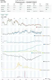
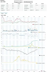
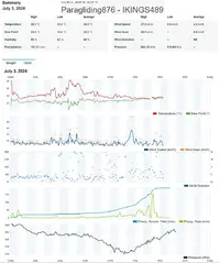
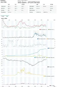
Beryl irreconhecível quase a largar a Jamaica, estrutura bastante desconjuntada. Isto significa que terá transferido uma grande quantidade de energia para a superfície e para todos os obstáculos no seu caminho, além de despejar uma enorme quantidade de água.
Quatro estações WU na área de Kingston, que podem dar uma ideia aproximada dos acumulados que puderam registar. Pelo resto da ilha não há estações com registo ou os registos não são fiáveis, por razões óbvias. A localização destas estações esteve relativamente protegida dos ventos e a zona estava fora da área com ventos previstos de furacão.
Os valores são estes:
219,7 mm
191,2 mm
181,1 mm
73,4 mm
Beryl mantém um aspecto desconjuntado e enfraquecido devido ao "westerly shear".
Os 100 nós (185 Km/h), de vento máximo sustentado, são conservadores mas ainda o classificam como Major Hurricane (Cat.3), estando prevista a continuação da diminuição da intensidade.
"
461
WTNT32 KNHC 041444
TCPAT2
BULLETIN
Hurricane Beryl Advisory Number 24
NWS National Hurricane Center Miami FL AL022024
1100 AM EDT Thu Jul 04 2024
...CENTER OF BERYL MOVING AWAY FROM THE CAYMAN ISLANDS...
...STRONG WINDS, DANGEROUS STORM SURGE, AND DAMAGING WAVES EXPECTED
ON THE COAST OF THE YUCATAN PENINSULA OF MEXICO BY EARLY FRIDAY...
SUMMARY OF 1100 AM EDT...1500 UTC...INFORMATION
-----------------------------------------------
LOCATION...19.0N 82.6W
ABOUT 95 MI...150 KM WSW OF GRAND CAYMAN
ABOUT 330 MI...530 KM ESE OF TULUM MEXICO
MAXIMUM SUSTAINED WINDS...115 MPH...185 KM/H
PRESENT MOVEMENT...WNW OR 285 DEGREES AT 18 MPH...30 KM/H
MINIMUM CENTRAL PRESSURE...971 MB...28.68 INCHES
WATCHES AND WARNINGS
--------------------
CHANGES WITH THIS ADVISORY:
None.
"
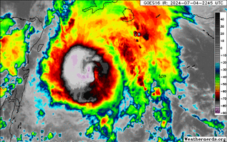
Durante 4 dias (96 horas) Beryl manteve-se como Major Hurricane, atingindo a categoria 4 ainda em Junho, e depois categoria 5 logo no dia 2 mantendo-se neste pico de intensidade pouco mais de 12 horas.
Hurricane Beryl Discussion Number 24
NWS National Hurricane Center Miami FL AL022024
1100 AM EDT Thu Jul 04 2024
Beryl continues to weaken due to the effects of westerly shear.
Radar data from the Cayman Islands shows that the eyewall is open
to the south and that there is very little precipitation occurring
in the southwestern semicircle. This matches the asymmetric cloud
pattern seen in satellite imagery. Data from the NOAA and Air
Force Reserve Hurricane Hunters support surface winds of 90-100 kt,
and that the central pressure has risen to near 971 mb. Based on
this, the initial intensity is reduced to a possibly generous 100
kt. The initial wind radii have be modified downward based on the
aircraft data.
The initial motion is 285/16. There is little change in either the
track forecast philosophy or the track forecast from the previous
advisory. A large ridge centered over the southeastern U.S. should
cause Beryl to move westward or west-northwestward during the next
day or two, with the model guidance tightly clustered about a
landfall on the Yucatan Peninsula just before 24 h and emerging into
the southwestern Gulf of Mexico just after 36 h. After that, Beryl
should turn northwest toward a developing break in the subtropical
ridge caused by a mid-latitude trough over the central United
States. This general motion should continue until the cyclone makes
landfall on the western Gulf coast near 96 h. While the guidance
has come into better agreement, there is a spread in the guidance
landfall points from northeastern Mexico to the middle Texas coast,
and users are reminded that the average error at day 4 is about 150
miles. Thus, it is still too early to pinpoint a specific region
for the worst hazards. The new official forecast is similar to, but
a touch slower than, the previous forecast and it lies close to the
consensus models.
Water vapor imagery continues to show a upper-level trough moving
west-southwestward over the southern Gulf of Mexico, with
westerly flow on the south side of this system helping to impart
moderate-to-strong shear over Beryl. While the shear could
decrease some during the next 24 h, it is unlikely to decrease
enough to stop Beryl from steadily weakening until landfall on the
Yucatan Peninsula. This part of the new intensity forecast follows
the trend of the intensity guidance. Beryl should weaken more
after landfall. There is uncertainty in how much shear the cyclone
may encounter over the Gulf of Mexico, but the guidance shows slow
intensification during that time. This is reflected in the new
intensity forecast that brings the system back to hurricane strength
right at landfall on the western Gulf coast.
Key Messages:
1. Strong winds, dangerous storm surge, damaging waves, and areas of
flooding are occurring in the Cayman Islands where a Hurricane
Warning remains in effect.
2. Hurricane-force winds, dangerous storm surge, and heavy rainfall
are expected over portions of the Yucatan Peninsula beginning
tonight as Beryl approaches that area as a hurricane. Hurricane and
Tropical Storm Warnings are in effect for portions of that area.
3. There is an increasing risk of strong winds, storm surge, and
heavy rainfall in portions of northeastern Mexico and southern Texas
later this weekend. Interests in these areas should closely monitor
the progress of Beryl and updates to the forecast.
4. Rip currents could cause life-threatening beach conditions
beginning late Friday and continuing through the weekend across much
of the Gulf coast.
Landfall previsto para uma área pouco habitada numa zona de cordão litoral e lagoas costeiras a sul de Tulum, trajectória do olho passando a sul da Ilha de Cozumel.
No entanto Cozumel poderá receber os ventos mais fortes dos quadrantes a Norte do olho, ou mesmo da parede deste, se ainda existir nessa altura.
Hora prevista da entrada em terra ao início da manhã (hora local, cerca das 13h de cá ou mais cedo):
BULLETIN
Hurricane Beryl Advisory Number 25
NWS National Hurricane Center Miami FL AL022024
500 PM EDT Thu Jul 04 2024
...CENTER OF BERYL HEADING FOR THE YUCATAN PENINSULA OF MEXICO...
...STRONG WINDS, DANGEROUS STORM SURGE, AND DAMAGING WAVES EXPECTED
ON THE COAST OF THE YUCATAN PENINSULA BY EARLY FRIDAY...
SUMMARY OF 500 PM EDT...2100 UTC...INFORMATION
----------------------------------------------
LOCATION...19.5N 84.3W
ABOUT 215 MI...345 KM ESE OF TULUM MEXICO
ABOUT 200 MI...325 KM W OF GRAND CAYMAN
MAXIMUM SUSTAINED WINDS...110 MPH...175 KM/H
PRESENT MOVEMENT...WNW OR 285 DEGREES AT 20 MPH...31 KM/H
MINIMUM CENTRAL PRESSURE...974 MB...28.77 INCHES
WATCHES AND WARNINGS
--------------------
CHANGES WITH THIS ADVISORY:
None. "
Reorganização do núcleo e olho suscitam incerteza sobre a possível diminuição do westerly shear e consequente recuperação de intensidade do furacão.
000
WTNT42 KNHC 042036
TCDAT2
Hurricane Beryl Discussion Number 25
NWS National Hurricane Center Miami FL AL022024
500 PM EDT Thu Jul 04 2024
The Air Force Reserve Hurricane Hunter aircraft that left the storm
around 17Z reported that the central pressure had risen to near 974
mb, and also reported flight-level and SFMR winds supporting an
intensity of 95 kt. Since that time, as happened yesterday
afternoon, despite the ongoing shear the eye has become better
defined in both satellite imagery and in radar data from Grand
Cayman and Cuba. Given this increase in central core organization,
the initial intensity will be held at 95 kt pending the arrival of
the next aircraft near 00Z. Satellite imagery also shows that the
outflow has become better defined in the northeastern semicircle.
The initial motion is 285/17, although the last several satellite
images suggest a westward wobble is in progress. There is again
little change in either the track forecast philosophy or the track
forecast from the previous advisory. A large ridge centered over
the southeastern U.S. should cause Beryl to move westward or
west-northwestward during the next day or so, with the model
guidance tightly clustered about a landfall on the Yucatan
Peninsula in 12-18 h and emerging into the southwestern Gulf of
Mexico at around 30 h. After that, Beryl should turn northwest
toward a developing break in the subtropical ridge caused by a
mid-latitude trough over the central United States. This general
motion should continue until the cyclone makes landfall on the
western Gulf coast between 72-96 h. There is still some spread in
the track guidance regarding a landfall location, with the range of
possibilities from northeastern Mexico to the middle Texas coast.
Users are reminded that the average track forecast error at day 3
is about 100 miles and at day 4 is about 150 miles, and so it is
still too early to pinpoint a specific region for the worst hazards.
The new official forecast is a little north of the previous
forecast through 24 h and similar to the previous forecast after
that.
It is unclear whether the current developments with the hurricane
core and outflow are temporary or a sign that the westerly shear
has somewhat abated. The intensity forecast follows the premise
that the shear has not fully abated and that Beryl will weaken
before landfall. However, even the intensity guidance that
forecasts weakening keeps Beryl at hurricane strength at landfall
on the Yucatan Peninsula. Additional weakening should occur while
the center is over land. Over the Gulf of Mexico, the guidance
does not forecast a lot of strengthening, but conditions appear
generally favorable and the intensity forecast continues to show
Beryl at hurricane strength before landfall on the western Gulf
coast. It should be noted that the dynamical models suggest that
the best chance for re-intensification could be during the last
12-18 hr before the western Gulf landfall, with the storm slow to
intensify before that time.
Key Messages:
1. Hurricane-force winds, dangerous storm surge, and heavy rainfall
are expected over portions of the Yucatan Peninsula beginning
tonight as Beryl approaches that area as a hurricane. Hurricane and
Tropical Storm Warnings are in effect for portions of that area.
2. There is an increasing risk of strong winds, storm surge, and
heavy rainfall in portions of northeastern Mexico and southern Texas
later this weekend. Interests in these areas should closely monitor
the progress of Beryl and updates to the forecast.
3. Rip currents could cause life-threatening beach conditions
beginning late Friday and continuing through the weekend across much
of the Gulf coast.
Mantém a mesma intensidade, 175 Km/h de ventos máximos sustentados, 974 hPa, rumo 285º.
Ainda não ocorreu o desvio da trajectória para W previsto na discussão 25.
E como consequência da ausência desse desvio para a esquerda, o local previsto para landfall é deslocado para norte, e está agora muito perto de Tulum, praticamente em cima diga-se, só ligeiramente a norte. Portanto, esta localidade vai sentir a inversão de ventos típica da passagem do olho, mesmo que o céu não abra, segundo esta nova previsão.
A ilha de Cozumel receberá ventos de furacão, o seu extremo sul podendo apanhar a parede norte do olho, caso este ainda exista.
Cat.2 inferior ou Cat.1 superior no landfall continental.
Considerando que o diâmetro da área com ventos de força furacão é nesta altura cerca de 50 milhas, a incerteza quanto ao ponto exacto de entrada em terra é quase irrelevante para Tulum.
Acumulados na Grand Cayman, ontem (dia local ainda incompleto):
Cerca de 70 a 110 mm distribuídos ao longo de 12 horas.
Rajada máxima de 111 Km/h naquela estação no sudoeste de George Town; 90 Km/h no nordeste de West Bay.
Hurricane Beryl Discussion Number 26
NWS National Hurricane Center Miami FL AL022024
1000 PM CDT Thu Jul 04 2024
The weakening trend of Beryl has reversed this evening. Satellite
images show that the eye has occasionally been evident and the
eyewall is about two-thirds closed based on Cancun radar images and
reports from the Air Force Hurricane Hunters. Data from the
reconnaissance mission indicated that Beryl has strengthened back to
a dangerous category 3 hurricane with maximum winds of about 100 kt.
The minimum pressure has fallen about 10 mb from this afternoon to
964 mb. The aircraft also indicated that Beryl remains compact, and
it is actually a little smaller than previously estimated.
The hurricane has turned westward and slowed down slightly on the
south side of a ridge centered over the southeastern U.S., with the
latest initial motion estimated to be 275/14 kt. Beryl is expected
to maintain that general motion during the next 12 hours, which
should cause it to make landfall in the Yucatan Peninsula very near
Tulum early Friday morning.
[...]
FORECAST POSITIONS AND MAX WINDS
A viragem para uma trajectória quase dirigida para Oeste já aconteceu, simultaneamente com a descida da pressão atmosférica e um aumento dos ventos máximos que voltam a pôr Beryl em categoria 3 (limite inferior).
A previsão de landfall volta também assim à de 24 horas atrás: um pouco a sul de Tulum.
Apesar de ter reduzido um pouco a sua dimensão, as imagens de satélite mostram mais uma vez que estas pequenas variações na exacta localização da entrada em terra são irrelevantes para os efeitos que serão sentidos numa larga área centrada em Tulum.
No entanto, no que respeita à ilha de Cozumel o desvio para a esquerda na trajectória já tem algum significado, apenas a metade sul da ilha estará dentro da área de ventos com força de furacão.
Faltam cerca de 5 horas para a chegada do núcleo central de Beryl à costa de Tulum; pouco mais de 6 horas para o landfall.