Grande Furacão IKE (Atlântico 2008 #09)

  • Thread starter Thread starter Vince
  • Data de início Data de início
Cuba comprou 2 ciclones por 1 trajecto igual:lmao: não tem piada mas quem diria que ele iria fazer o mesmo trajecto do Gustav, ao passar perto do mesmo sitio, é preciso ter azar.
 
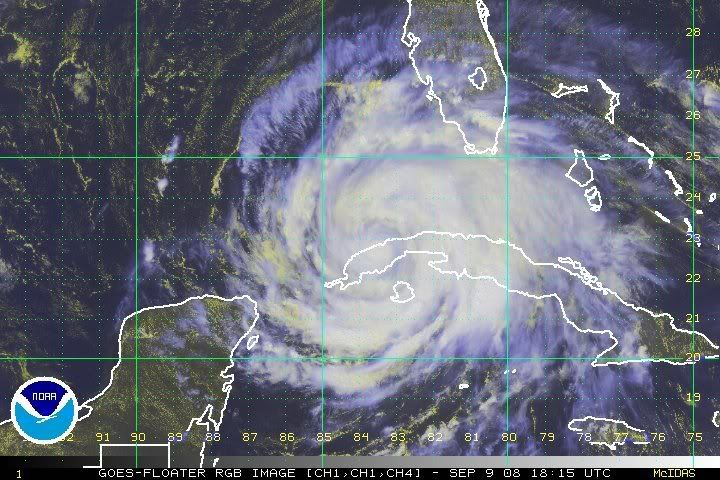
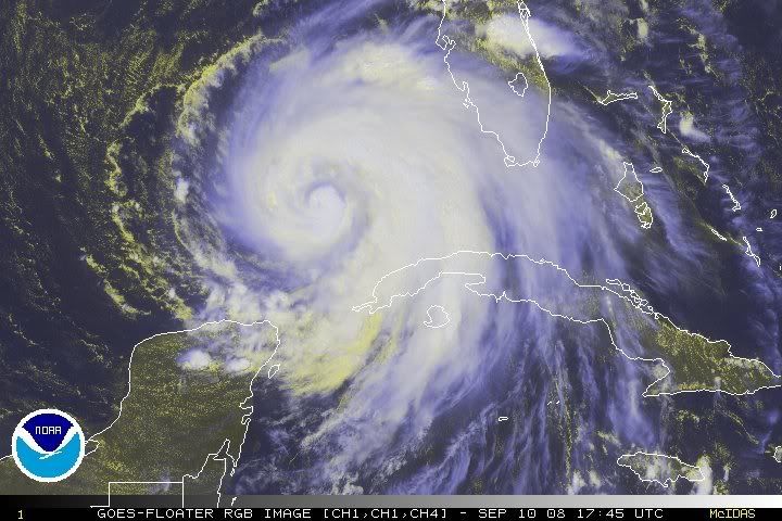
O IKE atravessa o oeste de Cuba e daqui a pouco estará no Golfo do México.
O serviço de meteorologia cubano registou uma rajada de 190 km/h em Paso Real/ Pinar del Rio.

rgb-l-8.jpg


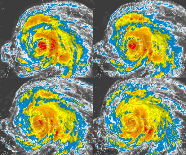
Apesar do tempo sobre terra não ser muito, esta animação mostra como é afectado com a convecção a diminuir um pouco:

loop-2.gif
 
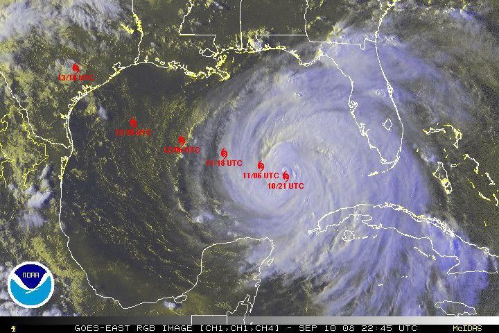
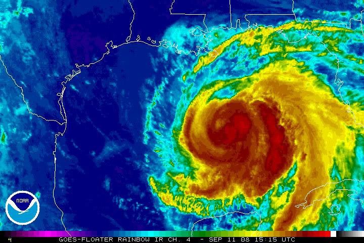
Agora no Golfo do México há algumas horas, o Ike parece querer desafiar aquela crista que os modelos dizem que o vai desviar para Oeste... Na animação do NHC parece estar a seguir mais para NW do que para WNW, embora o último aviso (há minutos) não faça referência a nenhuma alteração significativa das anteriores previsões...
 
Agora no Golfo do México há algumas horas, o Ike parece querer desafiar aquela crista que os modelos dizem que o vai desviar para Oeste... Na animação do NHC parece estar a seguir mais para NW do que para WNW, embora o último aviso (há minutos) não faça referência a nenhuma alteração significativa das anteriores previsões...

Até esta manhã havia alguma tendência nalguns modelos para um landfall mais próximo do México mas o GFS e outros juntaram-se ao ECM que era mais Texas. De qualquer forma ainda há bastante incerteza quanto a isso.

THE INITIAL MOTION IS 295/9...AND THERE HAS BEEN NO CHANGE TO THE
FORECAST TRACK THROUGH 48 HOURS AS IKE IS EXPECTED TO MOVE
GENERALLY WEST-NORTHWESTWARD FOR THE NEXT DAY OR TWO IN RESPONSE TO
A WEAKNESS IN THE SUBTROPICAL RIDGE OVER THE NORTHEASTERN GULF OF
MEXICO. THERE HAS BEEN A SIGNIFICANT NARROWING IN THE SPREAD OF THE
LATEST MODEL RUNS...WITH THE GFS...GFDL...AND NOGAPS ALL SHOWING
LESS RIDGING TO THE NORTH OF IKE LATE IN THE PERIOD AND SHIFTING
THEIR TRACKS NORTHWARD TO BE IN BETTER AGREEMENT WITH THE UKMET AND
ECMWF RUNS. IKE IS NOW EXPECTED TO RECURVE AROUND THE PERIPHERY OF
THE SUBTROPICAL RIDGE NEAR THE END OF THE FORECAST PERIOD. THE
OFFICIAL FORECAST IS ADJUSTED NORTHWARD ON DAYS FOUR AND FIVE...BUT
ALL OF THE BETTER DYNAMICAL MODELS ARE EVEN FARTHER TO THE RIGHT.


Reparem como o IKE se começou a expandir em tamanho nas últimas horas:

animyo3.gif
 
O Furacão IKE mantem-se como categoria 1 mas gradualmente vai se organizando, a convecção profunda vai crescendo cada vez mais. A pressão actual está em 963mb, medida há pouco por um avião de reconhecimento.

rb-l-3.jpg


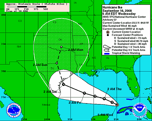
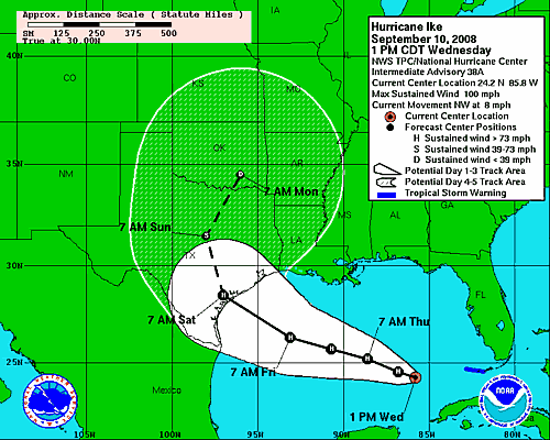
O trajecto previsto mantém-se para WNW, rumando em principio ao Texas onde chegaria na manhã de sábado como categoria 3, mas todos os que estão no cone tem que estar alertas dada a incerteza sempre existente.

084618W_sm.gif


Provavelmente já hoje começam a ser dadas ordens de evacuações no Texas.
 
Algumas imagens da 2.ª passagem do Ike por Cuba:

cienfuegos9setembrodz8.jpg

Cienfuegos, 9 Setembro.
Foto: EPA/ROLANDO PUJOL

0148281350085jy6.jpg

Cienfuegos, 9 Setembro.
Foto: EPA/ROLANDO PUJOL

0148281250085vf6.jpg

Havana, 9 Setembro
Foto: EPA/ALEJANDRO ERNESTO

0148286350085zx9.jpg

Havana, 9 Setembro (após a passagem do Ike).
Foto: EPA/ALEJANDRO ERNESTO
 
O IKE é neste momento um furacão de categoria 2, está com ventos da ordem dos 155 KM/HR. As previsões indicam que deve voltar a ser um grande furacão no decorrer das proximas 24 horas.
Há ainda uma grande incerteza sobre o local onde irá atingir terra.


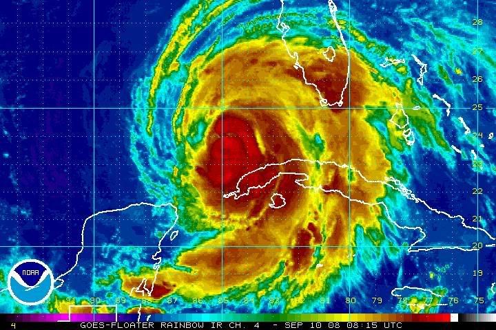
rgb-4.jpg


Fica aqui o aviso:
000
WTNT34 KNHC 101755
TCPAT4
BULLETIN
HURRICANE IKE INTERMEDIATE ADVISORY NUMBER 38A
NWS TPC/NATIONAL HURRICANE CENTER MIAMI FL AL092008
200 PM EDT WED SEP 10 2008

...IKE NOW A CATEGORY TWO HURRICANE...

A TROPICAL STORM WARNING REMAINS IN EFFECT FROM WEST OF KEY WEST TO
THE DRY TORTUGAS.

FOR STORM INFORMATION SPECIFIC TO YOUR AREA...INCLUDING POSSIBLE
INLAND WATCHES AND WARNINGS...PLEASE MONITOR PRODUCTS ISSUED
BY YOUR LOCAL WEATHER OFFICE.

AT 200 PM EDT...1800Z...THE CENTER OF HURRICANE IKE WAS LOCATED
NEAR LATITUDE 24.2 NORTH...LONGITUDE 85.8 WEST OR ABOUT 255 MILES...
410 KM...WEST OF KEY WEST FLORIDA AND ABOUT 395 MILES...
640 KM...SOUTH-SOUTHEAST OF THE MOUTH OF THE MISSISSIPPI RIVER.

IKE IS MOVING TOWARD THE NORTHWEST NEAR 8 MPH...13 KM/HR. A TURN
BACK TO THE WEST-NORTHWESTWARD MOTION IS EXPECTED LATER TODAY...AND
A MOSTLY WEST-NORTHWESTWARD MOTION THROUGH THE CENTRAL GULF OF
MEXICO IS EXPECTED OVER THE NEXT COUPLE OF DAYS.

MAXIMUM SUSTAINED WINDS ARE NOW NEAR 100 MPH...155 KM/HR...WITH
HIGHER GUSTS. IKE IS NOW A CATEGORY TWO HURRICANE ON THE
SAFFIR-SIMPSON SCALE. IKE IS EXPECTED TO BECOME A MAJOR HURRICANE
WITHIN THE NEXT 24 HOURS.

IKE IS A LARGE TROPICAL CYCLONE. HURRICANE FORCE WINDS EXTEND
OUTWARD UP TO 80 MILES...130 KM...FROM THE CENTER...AND TROPICAL
STORM FORCE WINDS EXTEND OUTWARD UP TO 205 MILES...335 KM.

THE LATEST MINIMUM CENTRAL PRESSURE REPORTED FROM AN AIR FORCE
RESERVE UNIT HURRICANE HUNTER AIRCRAFT WAS 958 MB...28.29 INCHES.

COASTAL STORM SURGE FLOODING ALONG THE COASTS OF CUBA AND IN THE
FLORIDA KEYS SHOULD SUBSIDE TODAY. ABOVE NORMAL TIDES OF 2 TO 4
FEET ARE ALREADY OCCURRING ALONG MUCH OF THE NORTH COAST OF THE
GULF OF MEXICO.

IKE IS EXPECTED TO PRODUCE TOTAL RAINFALL ACCUMULATIONS OF 6 TO 12
INCHES OVER WESTERN CUBA...WITH ISOLATED MAXIMUM AMOUNTS OF UP TO
20 INCHES POSSIBLE. THESE RAINS ARE LIKELY TO CAUSE
LIFE-THREATENING FLASH FLOODS AND MUD SLIDES OVER MOUNTAINOUS
TERRAIN. ADDITIONAL RAINFALL AMOUNTS OF AN INCH OR SO ARE POSSIBLE
OVER THE SOUTHWEST FLORIDA AND THE FLORIDA KEYS THROUGH THIS
EVENING.

REPEATING THE 200 PM EDT POSITION...24.2 N...85.8 W. MOVEMENT
TOWARD...NORTHWEST NEAR 8 MPH. MAXIMUM SUSTAINED WINDS...100
MPH. MINIMUM CENTRAL PRESSURE...958 MB.

THE NEXT ADVISORY WILL BE ISSUED BY THE NATIONAL
HURRICANE CENTER AT 500 PM EDT.

$$
FORECASTER FRANKLIN

151325W_sm.gif
 
Parece que a trajectória do Ike tem sido mais para NW do que inicialmente se previa. Aquando da animação da saída de Cuba e entrada no Golfo a sua trajectória era mais NW, mas toda as previsões apontavam numa correcção mais a Oeste, o que pelo que me parece não aconteceu. E por isso a previsão do landfall esteja a ser corrigida um pouco mais a NW.

hurricaneikelv0.png


O Ike parece-me enorme agora pelas imagens de satélite e dada esta aparente correcção mais a NW a costa do Louisiana vai sofrer por certo os efeitos de novo ciclone tropical.

Embora a maioria das previsões apontem para um Cat. 3 na altura do landfall, ontem havia alguns noticiários e projecções que não punham de parte um Cat. 4.
 
Parece que a trajectória do Ike tem sido mais para NW do que inicialmente se previa.

A questão tem a ver com o timming da curvatura que se dá com o enfraquecimento da crista anticiclónica. A curvatura em si estava prevista desde há alguns dias mas ainda existe alguma discordância entre os modelos quanto ao momento certo em que isso vai suceder. Além do enfraquecimento da crista entra na equação a velocidade a que se desloca o IKE podendo apanhar esse enfraquecimento mais cedo ou mais tarde. Tudo coisas complicadas de gerir em termos de previsões. Assim os que curvam mais tarde (como o HWRF) tem um landfall à esquerda da linha do cone, os outros (como o GFDL) mais à direita. Mas por isso é que o NHC repete constantemente que as pessoas se tem que concentrar no cone e não na linha, o próprio nome da previsão do NHC é "cone de x dias" e não "linha de x dias".

THERE
CONTINUES TO BE SOME DISAGREEMENT AMONG THE MODELS AS TO HOW SOON
AND HOW SHARP OF A TURN WILL OCCUR. HOWEVER...THE CONSENSUS OF OUR
MOST RELIABLE TRACK FORECAST MODELS IS UNCHANGED FROM THE PREVIOUS
ADVISORY. THEREFORE I HAVE MADE ESSENTIALLY NO CHANGES TO THE
OFFICIAL TRACK FORECAST. THIS IS BETWEEN THE LATEST HWRF
RUN...WHICH IS TO THE LEFT OF THE OFFICIAL FORECAST...AND THE
LATEST GFDL RUN....WHICH IS TO THE RIGHT. IN THIS CASE IT IS
PARTICULARLY IMPORTANT NOT TO FOCUS ON THE EXACT FORECAST TRACK
SINCE DAMAGING WINDS EXTEND SO FAR FROM THE CENTER.


O cenário do IKE poderá ser idêntico ao do Furacão Carla de 1961 que provocou muitos estragos no Texas, o storm surge por exemplo foi brutal.

Carla 1961
180px-Carla_1961_track.png

http://en.wikipedia.org/wiki/Hurricane_Carla


Se por acaso a curvatura se der mais cedo podermos ter algo parecido com o Rita em 2005, durante vários dias era mais Texas e depois acabou na fronteira entre o Texas e a Lousiana, é uma hipotese que ainda está em aberto pois basta olhar para o cone de incerteza. Na altura foi uma situação muito complicada pois muita gente fugiu para leste e o Furacão também foi mais para leste. Estas questões das evacuações são por vezes complexas e não se tomam de animo leve por causa deste tipo de incerteza. É preciso ter cuidado em escolher o sitio para onde as pessoas devem ir não vão as pessoas depois meterem-se numa situação mais chata do que estariam se tivessem permanecido.

Rita 2005
180px-Rita_2005_track.png

http://en.wikipedia.org/wiki/Hurricane_Rita
 
Mas por isso é que o NHC repete constantemente que as pessoas se tem que concentrar no cone e não na linha, o próprio nome da previsão do NHC é "cone de x dias" e não "linha de x dias".

Quando falava na trajectória...falava da possível trajectória, ou seja do cone de incerteza que se tem movido um pouco mais para NW.

É claro que a própria trajectória do Ike está dentro do cone de incerteza anteriormente previsto...má escolha de palavras. Deveria ter dito que o cone se tem deslocado um pouco mais para NW e não a trajectória. :)
 
Ordenada há pouco a evacuação mandatária de Jefferson e Orange no Texas:

Mandatory Evacuation Called for Jefferson and Orange County
Date: September 11, 2008 07:00 Hours

Elected Officials in Jefferson and Orange County have called for a mandatory evacuation effective at 6:00 am today. Elected Officials in Hardin County have not called for an evacuation at this time. Officials learned during the night that the State of Texas will be sending resources to our region today to assist in the evacuation process. The track of Hurricane Ike has been uncertain but has been moving slightly north along the coast. Due to this movement and the availability of resources, the decision was made to call for the evacuation.
Beaumont Transit buses will not be running regular routes today. They will only be operating in support of the evacuation effort. Buses should should start running at 8:00 AM today. Beaumont residents needing assistance in transportation for evacuation should begin moving to the assembly sites.
Beaumont assembly sites are;
1. Dunbar Elementary - 825 Jackson
2. French Elementary - 3525 Cleveland
3. Martin Luther King Middle School - 1400 Ave A
4. Ozen High School-3443 Fannett Rd
5. Smith Middle Sdchool-4415 Concord
6. South Park Middle School-4500 Highland Ave

The Main Assembly Point is Westbrook High School at 8750 Phelan Blvd. If someone has a car and can get to Westbrook HS, they can be evacuated by bus.
 
Vai chegar com cat 4

Texans flee 7 coastal counties ahead of IkeStory Highlights
NEW: Ike could swell to Category 4 hurricane when it hits Texas coast

Mandatory, voluntary evacuations under way in at least seven Texas counties

Texans in low-lying areas and mobiles homes urged to get out

Next Article in U.S. »


Read VIDEO PHOTOS MAP

(CNN) -- Texans are fleeing from seven coastal counties ahead of Hurricane Ike on Thursday after officials ordered mandatory evacuations and planned even more voluntary ones.


Earl Barnes waits to be evacuated from a senior center in Corpus Christi, Texas, on Wednesday.

1 of 3 more photos » Forecasters said the storm could slam into the Texas coast -- south of Galveston -- as a powerful Category 4 storm late Friday or early Saturday.

Aransas County has ordered a mandatory evacuation of all nonessential government employees, becoming the latest county to urge residents to flee.

In Galveston, city officials ordered mandatory evacuations for part of the island town beginning at 7 a.m. CT (8 a.m. ET) Thursday. The rest of the town will be under a voluntary evacuation order. Only residents will be required to evacuate on the western end of the island.

Mayor Lyda Ann Thomas defended this decision, saying current models call for Galveston to be hit with winds and rain only equivalent to a Category 1 hurricane.

"We do not intend to evacuate Galveston Island," she said. "It's the last thing we want to do. Our job is to protect lives and property, [and] right now we feel that sheltering in place is the best action for our citizens to take."

Farther up the Gulf Coast and closer to where the National Hurricane Center predicts a direct hit, Brazoria County ordered a mandatory evacuation to begin at 8 a.m. CT (9 a.m. ET) Thursday. Some other Texas localities have ordered mandatory evacuations, while others have left the decision to depart up to residents.

Don't Miss
KPRC: Galveston gears up for Ike
KSAT: Hospitals fly kids away from Ike
Hurricane tears up Grand Turk tourism
iReport.com: Are you in Ike's path? Send your pics, video
Impact Your World
See how you can make a difference
As of 5 a.m. ET Thursday, the Category 2 storm -- with top sustained winds near 100 mph -- was about 620 miles east of Brownsville, Texas, and about 285 miles southeast of the Mississippi River, the hurricane center said. Track the storm »

Hurricane-force winds extended out up to 115 miles from the storm's center, and tropical storm-force winds extended out up to 255 miles forecasters reported.

In Matagorda County, southwest of Galveston, officials ordered a mandatory evacuation for all areas except the cities of Bay City and Van Vleck.

The evacuation must be completed by at 6 p.m. (7 p.m. ET) Thursday. Galveston is likely to experience a high tidal surge, officials said, urging people living in low-lying areas or mobile homes to get out soon.

"One of the things that the public has to understand if they decide to stay, there will be a period of time during this storm when they will absolutely be on their own," Brazoria County Sheriff Charles Wagner said.

"There will be no medical services; there will be no fire department; there will be no law enforcement, groceries, gasoline, drugs, electricity."

The center issued a tropical storm warning from the Mississippi River's mouth to Cameron, Louisiana, and a hurricane watch from Cameron to Port Mansfield, Texas, about 60 miles south of Brownsville. Tropical storm warnings mean winds of 39 mph to 73 mph are expected within a day, and a hurricane watch means winds of 74 and higher are expected within 36 hours.

"Hurricane Ike is now in the Gulf of Mexico and making its approach toward our coast," Gov. Rick Perry said in a statement. "The next few days will be crucial for residents to follow the direction of local leaders and to take the necessary steps to protect themselves and their families."

Perry put 7,500 National Guard members on standby and issued a disaster declaration for 88 counties.

About 1,350 buses as well as ambulances and paramedic buses were available to support evacuations. The vehicles were positioned near Houston and Matagorda, Nueces and Victoria counties, the governor's office said.

President Bush declared an emergency, making federal funds available for the state to prepare for the storm.

Corpus Christi officials also began the evacuation process for residents with special needs, supplying buses to transport them out of town.

Voluntary evacuations were issued in San Patricio and Victoria counties and parts of Jackson County, according to the governor's office.

More than 1,300 inmates from the Texas Correctional Institutions Division's Stevenson Unit in Cuero were being evacuated to facilities in Beeville and Kenedy, Perry's office said, and 597 were transferred from the substance abuse Glossbrenner Unit in San Diego, in south Texas, to Dilley.

Naval air stations in Texas also began to prepare for Hurricane Ike's expected arrival. Naval Air Station Kingsville was to begin moving about 50 aircraft to El Paso, San Antonio and Fort Worth on Wednesday afternoon, the public affairs office there said. Naval Air Station Corpus Christi also will move about 75 aircraft to other Texas locations.

Evacuations appeared to have saved lives in Cuba when Ike slammed into the island. Four deaths were reported from the storm, according to the Cuban government. The Cuban Civil Defense brought buses or trucks to take people to shelters. See the damage from the storm »

The United States, which provided $100,000 in emergency aid to communist-run Cuba through private aid agencies after Hurricane Gustav hit the island August 30, said that it was considering additional emergency aid for Cuba because of Ike. Watch as winds and waves pound Cuba »

Also, the United States said it will lift restrictions on cash and humanitarian assistance sent to Cuba for the next 90 days. The move will allow nongovernmental organizations to provide assistance and cash donations.


The storm pounded Grand Turk Island in the Turks and Caicos chain, putting a strain on the British territory's tourism industry. Watch houses lie in heaps on Grand Turk »

Flooding and rains from Ike's outer bands have been blamed for 70 deaths in Haiti.
E-mail to a friend
Share this on:
Mixx
Digg

Facebook

del.icio.us

reddit

StumbleUpon

MySpace
| Mixx it | Share

CNN's Mike Mount contributed to this report.

All About Texas • Cuba • Haiti
 
ike-15.jpg


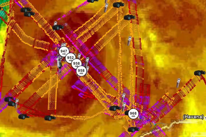
A situação do IKE mantém-se curiosa. É um ciclone enorme com um campo de vento alargado, tem a pressão estável nos 947mb o que já são pressões de furacões mais fortes, mas por muito que procurem, os aviões não conseguem até ao momento encontrar ventos que suportem por exemplo a categoria 3.

DATA FROM AIR FORCE AND NOAA AIRCRAFT INDICATE THAT IKE IS
MAINTAINING AN ATYPICAL WIND STRUCTURE...CHARACTERIZED BY A VERY
BROAD WIND FIELD WITH MULTIPLE WIND MAXIMA AND RELATIVELY LITTLE
TRANSPORT OF WINDS ALOFT DOWN TO THE SURFACE. THE NOAA AIRCRAFT
REPORTED MAXIMUM FLIGHT-LEVEL WINDS OF 103 KT 100 NMI
NORTH-NORTHEAST OF THE CENTER...BUT SFMR AND DROPSONDE DATA
INDICATE THAT THE SURFACE WINDS IN THAT AREA WERE ONLY AROUND 65
KT. IN FACT...THERE HAS BEEN NOTHING AT THE SURFACE RECENTLY THAT
QUITE SUPPORTS THE CURRENT 85 KT
ADVISORY INTENSITY.

Explicações ? Tem a ver com a situação das duas paredes do olho no processo que o IKE estava a iniciar antes de entrar pela primeira vez em Cuba, processo esse que nunca chegou a concluir mantendo-se até hoje. Essa debilidade estrutural tem permitido que continuem a ocorrer pelo noroeste incursões de ar seco pelo interior do núcleo. Enquanto não existir uma parede sólida a fechar o olho o IKE não se intensifica muito mais. O resultado é um furacão com ventos intensos espalhados por uma área superior ao normal, sobretudo a nordeste, mas com ventos não tão extremos junto ao núcleo como seria de esperar com a pressão actual.

Durante o dia de hoje tem vindo a melhorar nesse aspecto, mas o ultimo voo ainda encontrou a parede aberta a noroeste.

L. Eye Character: Open in the northwest
M. Eye Shape & Diameter: Circular with a diameter of 10 nautical miles (12 statute miles)


IKE é um furacão perigoso que vai fazer muitos estragos com um storm surge significativo e muita precipitação, mas dado que passou já na zona mais perigosa do maior Eddy julgo que há alguma esperança que com isto tudo que pelo menos não chegue a Categoria 4, de resto é essa a previsão do NHC.