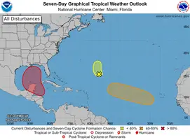
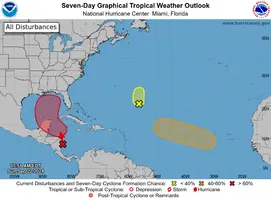
Parece que a 'hurricane season' é desta que vai explodir, mas terá de contar ainda com ar seco:

000
WTNT42 KNHC 111455
TCDAT2
Tropical Depression Seven Discussion Number 1
NWS National Hurricane Center Miami FL AL072024
Issued by the NWS Weather Prediction Center College Park MD
200 PM CVT Wed Sep 11 2024
[...]
Wind shear is not expected to be a big hindrance in its
development initially while SSTs along its forecast path will
generally be around 27C. Thus gradually intensification is shown
for the first couple of days. However, shear is forecast to
increase thereafter along with more marginal dry air conditions.
This forecast leans more heavily on the regional hurricane models
which show more modest intensification than the statistical
dynamical tools but could be conservative at the end depending on
how much latitude the system gains.
FORECAST POSITIONS AND MAX WINDS
INIT 11/1500Z 16.0N 28.7W 30 KT 35 MPH
12H 12/0000Z 16.6N 31.2W 35 KT 40 MPH
24H 12/1200Z 17.5N 34.1W 40 KT 45 MPH
36H 13/0000Z 18.6N 36.7W 45 KT 50 MPH
48H 13/1200Z 19.3N 39.3W 45 KT 50 MPH
60H 14/0000Z 19.9N 41.9W 45 KT 50 MPH
72H 14/1200Z 20.3N 43.9W 45 KT 50 MPH
96H 15/1200Z 20.6N 46.6W 45 KT 50 MPH
120H 16/1200Z 21.0N 48.8W 45 KT 50 MPH
$$
Forecaster Mullinax/Blake