Actividade a aumentar, probabilidades de 40% (Golfo) e 60% (atrás da Joyce):

Previsão e Seguimento de Furacões (Atlântico 2024)
- Thread starter StormRic
- Data de início
-
O novo portal está no ar! Novos meteogramas, cartas, e mais. Mais informações neste tópico
Seguimento Meteorológico: Litoral Norte | Interior Norte e Centro | Litoral Centro | Sul | Açores e Madeira | Livre
Previsões: Curto e médio prazo: até 2 semanas | Longo prazo: mensal e sazonal (Regras e links úteis nos 1ºs posts)
Facebook | Avisos IPMA/Alertas ANEPC
You are using an out of date browser. It may not display this or other websites correctly.
You should upgrade or use an alternative browser.
You should upgrade or use an alternative browser.

Afgdr
Cumulonimbus
Panorama atual no Atlântico:

1) Furacão Isaac com ventos máximos sustentados de 75 mph (cat 1), em enfraquecimento;
2) Tempestade Tropical Joyce com ventos máximos sustentados de 45 mph, em enfraquecimento;
3) Invest 90L com 60% e 80% de probabilidade de se tornar ciclone tropical em 2 e 7 dias, respetivamente;

4) Onda tropical na costa de África Ocidental com baixo potencial ciclónico (0% e 20% em 2 e 7 dias respetivamente);
5) Área de baixas pressões nas Caraíbas Ocidentais com baixo potencial ciclónico em 2 dias (0%) e médio em 7 dias (50%).
1) Furacão Isaac com ventos máximos sustentados de 75 mph (cat 1), em enfraquecimento;
2) Tempestade Tropical Joyce com ventos máximos sustentados de 45 mph, em enfraquecimento;
3) Invest 90L com 60% e 80% de probabilidade de se tornar ciclone tropical em 2 e 7 dias, respetivamente;
1. Eastern and Central Tropical Atlantic (AL90):
Showers and thunderstorms associated with an elongated area of low
pressure located a few hundred miles west-southwest of the Cabo
Verde Islands have become better organized since yesterday.
Environmental conditions are conducive for gradual development of
this system, and a tropical depression is likely to form during the
early or middle part of this week while the system initially moves
westward and then northwestward across the eastern and central
tropical Atlantic.
* Formation chance through 48 hours...medium...60 percent.
* Formation chance through 7 days...high...80 percent.
4) Onda tropical na costa de África Ocidental com baixo potencial ciclónico (0% e 20% em 2 e 7 dias respetivamente);
3. Eastern Atlantic:
A tropical wave located near the coast of western Africa is
currently producing limited shower activity. Some gradual
development of this system is possible during the next several days
while it moves slowly westward or west-northwestward over the
eastern Atlantic Ocean.
* Formation chance through 48 hours...low...near 0 percent.
* Formation chance through 7 days...low...20 percent.
5) Área de baixas pressões nas Caraíbas Ocidentais com baixo potencial ciclónico em 2 dias (0%) e médio em 7 dias (50%).
2. Western Caribbean Sea and Gulf of Mexico:
A broad area of low pressure located over the western Caribbean Sea
is producing disorganized showers and thunderstorms. Environmental
conditions appear to be conducive for gradual development, and a
tropical depression could form around the middle part of this week
while the disturbance meanders towards the west-northwest. This
system is then expected to move northwestward into the Gulf of
Mexico during the latter portion of this week, and interests in the
northwestern Caribbean Sea and along the U.S. Gulf Coast should
monitor its progress.
* Formation chance through 48 hours...low...near 0 percent.
* Formation chance through 7 days...medium...50 percent.
Afgdr
Cumulonimbus
AL90 é agora a Depressão Tropical 12 - futuro Kirk.
Tópico de seguimento: https://www.meteopt.com/forum/topico/depressao-tropical-12-atlantico-2024-al12.11242/
Tópico de seguimento: https://www.meteopt.com/forum/topico/depressao-tropical-12-atlantico-2024-al12.11242/
Última edição:
MSantos
Moderação
AL90 é agora a Depressão Tropical 12 - futuro Kirk.
Tópico de seguimento: https://www.meteopt.com/forum/topico/depr
Tópico atualizado, a Depressão Tropical 12 já foi nomeada. KIRK já é TT. Todo o seguimento do sistema KIRK passa para o tópico respetivo.
MSantos
Moderação
Estava a custar a arrancar, mas agora atividade não falta no Atlântico! Bastante provável termos ainda esta semana mais dois sistemas nomeados.
Última edição:
Afgdr
Cumulonimbus
O Invest 91L foi classificado pelo NHC como Depressão Tropical 13 - futuro Leslie.
Tópico de seguimento: https://www.meteopt.com/forum/topico/depressao-tropical-13-atlantico-2024-al13.11250/
Tópico de seguimento: https://www.meteopt.com/forum/topico/depressao-tropical-13-atlantico-2024-al13.11250/
Afgdr
Cumulonimbus
Situação atual na bacia do Atlântico:

1) Furacão Kirk (130 mph - cat 4) em fase de declínio (seguimento em tópico próprio);
2) Tempestade Tropical Leslie (70 mph) em fase de desenvolvimento (seguimento em tópico próprio);
3) Área de baixas pressões no Golfo do México (Invest 92L) com baixo (30%) e alto (70%) potencial ciclónico em 2 e 7 dias, respetivamente;

4) Onda tropical emergente no Atlântico Tropical Oriental na próxima semana com baixo potencial ciclónico em 2 (0%) e 7 dias (30%).
1) Furacão Kirk (130 mph - cat 4) em fase de declínio (seguimento em tópico próprio);
2) Tempestade Tropical Leslie (70 mph) em fase de desenvolvimento (seguimento em tópico próprio);
3) Área de baixas pressões no Golfo do México (Invest 92L) com baixo (30%) e alto (70%) potencial ciclónico em 2 e 7 dias, respetivamente;
1. Gulf of Mexico:
A broad area of low pressure located over the southwestern Gulf of
Mexico is producing disorganized showers and thunderstorms.
Gradual development of this system is expected, and a tropical or
subtropical depression or storm is likely to form late this weekend
or early next week while the system moves eastward or northeastward
across the Gulf of Mexico. Interests in the Florida Peninsula and
the Florida Keys should monitor the progress of this system.
Regardless of tropical or subtropical development, locally heavy
rains could occur over portions of Mexico during the next day or
two, and over much of Florida late this weekend through the middle
of next week.
* Formation chance through 48 hours...low...30 percent.
* Formation chance through 7 days...high...70 percent.
4) Onda tropical emergente no Atlântico Tropical Oriental na próxima semana com baixo potencial ciclónico em 2 (0%) e 7 dias (30%).
2. Far Eastern Tropical Atlantic:
A tropical wave is expected to move off the west coast of
Africa on Monday or Tuesday. Some development of this system is
possible thereafter while it moves westward or west-northwestward
across the eastern tropical Atlantic. Interests in the Cabo Verde
Islands should monitor the progress of this system.
* Formation chance through 48 hours...low...near 0 percent.
* Formation chance through 7 days...low...30 percent.
Última edição:
Afgdr
Cumulonimbus
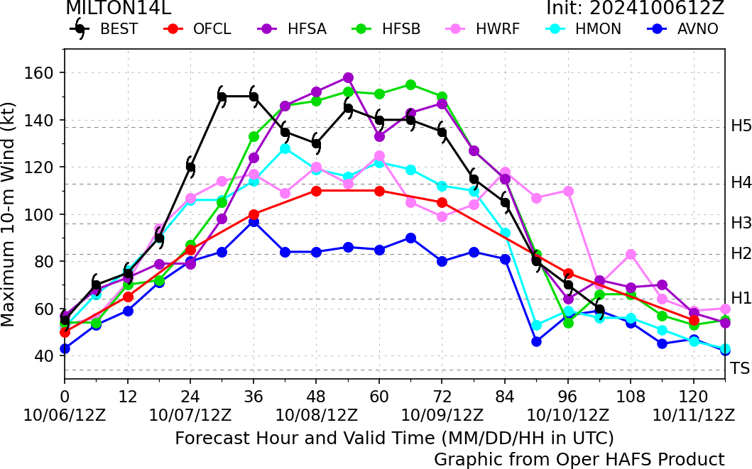
Aumentou a probabilidade de AL92 se tornar ciclone tropical em 2 (70%) e 7 dias (90%).
A confirmar-se o seu desenvolvimento nos próximos dias, será nomeado Milton.
Poderá vir a afetar novamente o estado da Flórida, recentemente atingido pelo Furacão Helene.

A confirmar-se o seu desenvolvimento nos próximos dias, será nomeado Milton.
Poderá vir a afetar novamente o estado da Flórida, recentemente atingido pelo Furacão Helene.
1. Gulf of Mexico (AL92):
Showers and thunderstorms associated with a broad area of low
pressure located over the southwestern Gulf of Mexico are gradually
becoming better organized. Development of this system is expected,
and a tropical depression or storm is likely to form later today or
on Sunday while it moves slowly eastward over the southwestern Gulf
of Mexico. By early next week, the system is forecast to move
faster eastward or northeastward across the central and eastern Gulf
of Mexico where additional strengthening is likely. Interests on
the Yucatan peninsula of Mexico, the Florida Peninsula, the Florida
Keys, and the northwestern Bahamas should monitor the progress of
this system. Regardless of development, locally heavy rains could
occur over portions of Mexico during the next day or two, and over
much of Florida late this weekend through the middle of next week.
* Formation chance through 48 hours...high...70 percent.
* Formation chance through 7 days...high...90 percent.
Afgdr
Cumulonimbus
O Invest 92L tornou-se a Depressão Tropical 14, que futuramente será nomeada Milton.
Tópico de seguimento: https://www.meteopt.com/forum/topico/depressao-tropical-14-atlantico-2024-al14.11251/
Tópico de seguimento: https://www.meteopt.com/forum/topico/depressao-tropical-14-atlantico-2024-al14.11251/


Tipicamente: 14 tempestades, 7 furacões e 3 Majors.
Incluindo a previsão do Milton, vai-se em (salvo erro) 13 tempestades, 9 furacões e 3 majors.
Caminho aberto para uma temporada 'normal'.

Provavelmente já não haverão mais CTs de África.
(assumo que o NHC errou. 2º November = December)
Para além da bizarria em África, um dos mais importantes fatores da previsão não se concretizou. A ENSO está neutra.


Última edição:
Importância da diversidade. OFCL = NHC; BEST = histórico https://www.nhc.noaa.gov/modelsummary.shtml
Última edição:
Afgdr
Cumulonimbus
Tem ocorrido muita atividade tropical no Atlântico. Este é o panorama atual:

1) Furacão Milton (cat 5) em intensificação (seguimento aqui);
2) Furacão Leslie (cat 1) a enfraquecer (seguimento aqui);
3) Ciclone Extratropical Kirk a passar a N dos Açores (seguimento aqui);
4) Perturbação perto da Flórida/Bahamas com baixo potencial ciclónico (10%) em 2/7 dias;
5) Onda tropical na África Ocidental com baixo potencial ciclónico em 2 (0%) e 7 dias (30%).
1) Furacão Milton (cat 5) em intensificação (seguimento aqui);
2) Furacão Leslie (cat 1) a enfraquecer (seguimento aqui);
3) Ciclone Extratropical Kirk a passar a N dos Açores (seguimento aqui);
4) Perturbação perto da Flórida/Bahamas com baixo potencial ciclónico (10%) em 2/7 dias;
1. Southwestern Atlantic:
An area of disturbed weather located across portions of South
Florida, the Florida Straits and the northwestern Bahamas is
expected to move northeastward, where an area of low pressure could
form near the northwestern Bahamas. Some limited tropical or
subtropical development is possible while the low moves
northeastward to east-northeastward around 15 mph. However,
upper-level winds are likely to increase in a couple days, which
should prevent any further development.
* Formation chance through 48 hours...low...10 percent.
* Formation chance through 7 days...low...10 percent.
5) Onda tropical na África Ocidental com baixo potencial ciclónico em 2 (0%) e 7 dias (30%).
2. Far Eastern Tropical Atlantic:
A tropical wave is expected to move off the west coast of Africa in
a couple days. Afterward, environmental conditions appear
marginally favorable for some slow development of this system while
it moves westward or west-northwestward across the eastern tropical
Atlantic. The system is expected to move near or over the Cabo
Verde Islands on Thursday or early Friday, and interests there
should monitor its progress.
* Formation chance through 48 hours...low...near 0 percent.
* Formation chance through 7 days...low...30 percent.