Previsão e Seguimento de Furacões (Atlântico 2024)

A parede norte do olho e algumas bandas periféricas nos quadrantes norte aparecem no radar de Bermuda, há 15 minutos (2:55utc):

2024-08-17-0255_250km_sri.png


2024-08-17-0301_100km_sri.png


Note-se o reduzido tamanho da ilha de Bermuda na área abrangida pela precipitação forte de Ernesto:
2024-08-17-0313_100km_sri.webp


Aproximação ao aeroporto:

 
Última edição:
Várias bandas de precipitação concêntricas só agora permitem dizer que a parede do olho ainda não entrou em terra:


Há acumulados na última hora a excederem os 40mm.

Apenas 5 anemómetros WU ainda registam.
Só 4 pluviómetros com valores fiáveis.
Direcção ESE predomina, o centro do olho é quase certo que vai passar pelo meio da ilha.
 
Última edição:
000
WTNT35 KNHC 170231
TCPAT5

BULLETIN
Hurricane Ernesto Advisory Number 22
NWS National Hurricane Center Miami FL AL052024
1100 PM AST Fri Aug 16 2024

...ERNESTO VERY NEAR BERMUDA...
...STRONG WINDS, DANGEROUS STORM SURGE, AND LIFE-THREATENING
FLOODING OCCURRING ON THE ISLAND...


SUMMARY OF 1100 PM AST...0300 UTC...INFORMATION
-----------------------------------------------
LOCATION...31.4N 65.2W
ABOUT 65 MI...105 KM SSW OF BERMUDA
MAXIMUM SUSTAINED WINDS...90 MPH...150 KM/H
PRESENT MOVEMENT...NNE OR 30 DEGREES AT 13 MPH...20 KM/H
MINIMUM CENTRAL PRESSURE...969 MB...28.62 INCHES


WATCHES AND WARNINGS
--------------------
CHANGES WITH THIS ADVISORY:

None.

SUMMARY OF WATCHES AND WARNINGS IN EFFECT:

A Hurricane Warning is in effect for...
* Bermuda

A Hurricane Warning means that hurricane conditions are expected
somewhere within the warning area.

For storm information specific to your area, please monitor
products issued by your national meteorological service.


DISCUSSION AND OUTLOOK
----------------------
At 1100 PM AST (0300 UTC), the center of Hurricane Ernesto was
located near latitude 31.4 North, longitude 65.2 West. Ernesto is
moving toward the north-northeast near 13 mph (20 km/h). A gradual
slowdown is expected during the next day or so. An accelerating
northeastward motion is then expected late this weekend into early
next week. On the forecast track, the center of Ernesto is expected
to pass near or over Bermuda Saturday morning and near or east of
Newfoundland Monday night.

Maximum sustained winds are near 90 mph (150 km/h) with higher
gusts. Some gradual weakening is forecast over the next day or so,
though some re-intensification is possible late in the weekend.

Ernesto is a large tropical cyclone. Hurricane-force winds extend
outward up to 70 miles (110 km) from the center and
tropical-storm-force winds extend outward up to 275 miles (445 km).
The Bermuda International Airport recently reported sustained winds
of 52 mph (84 km/h) with a gust to 74 mph (120 km/h).

The estimated minimum central pressure based on data from an Air
Force Hurricane Hunter aircraft is 969 mb (28.62 inches).


HAZARDS AFFECTING LAND
----------------------
Key messages for Ernesto can be found in the Tropical Cyclone
Discussion under AWIPS header MIATCDAT5 and WMO header WTNT45 KNHC
and on the web at hurricanes.gov/text/MIATCDAT5.shtml.

WIND: Winds on Bermuda are expected to increase to hurricane force
early Saturday. Due to Ernesto's large size and slow motion, strong
winds will continue on the island into Saturday night.

STORM SURGE: A dangerous storm surge is expected to produce
significant coastal flooding on Bermuda in areas of onshore winds.
Near the coast, the surge will be accompanied by large and
destructive waves.

RAINFALL: Ernesto is expected to produce total rain accumulations of
6 to 9 inches or 150 to 225 mm on Bermuda. This rainfall will likely
result in considerable life-threatening flash flooding, especially
in low-lying areas on the island.

SURF: Swells generated by Ernesto are affecting portions of the
the Bahamas, Bermuda, and the east coast of the United States.
These swells will likely reach portions of Atlantic Canada by late
Saturday. Life-threatening surf and rip current conditions are
likely in these areas during the next couple of days. Please
consult products from your local weather office, and stay out of
the water if advised by lifeguards.


NEXT ADVISORY
-------------
Next intermediate advisory at 200 AM AST.
Next complete advisory at 500 AM AST.

$$
Forecaster Cangialosi

No aeroporto, no norte da ilha, vento sustentado >80 Km/h e rajadas que já atingiram um máximo de 135 Km/h.

BWS_aeroporto_20240817-0455utc.png


000
WTNT35 KNHC 170555
TCPAT5

BULLETIN
Hurricane Ernesto Intermediate Advisory Number 22A
NWS National Hurricane Center Miami FL AL052024
200 AM AST Sat Aug 17 2024

...ERNESTO LASHING BERMUDA WITH STRONG WINDS, DANGEROUS STORM
SURGE, AND LIFE-THREATENING FLOODING...


SUMMARY OF 200 AM AST...0600 UTC...INFORMATION
----------------------------------------------
LOCATION...32.0N 65.1W
ABOUT 25 MI...40 KM SW OF BERMUDA
MAXIMUM SUSTAINED WINDS...90 MPH...150 KM/H
PRESENT MOVEMENT...NNE OR 30 DEGREES AT 13 MPH...20 KM/H
MINIMUM CENTRAL PRESSURE...972 MB...28.70 INCHES


WATCHES AND WARNINGS
--------------------
CHANGES WITH THIS ADVISORY:

None.

SUMMARY OF WATCHES AND WARNINGS IN EFFECT:

A Hurricane Warning is in effect for...
* Bermuda

A Hurricane Warning means that hurricane conditions are expected
somewhere within the warning area.

For storm information specific to your area, please monitor
products issued by your national meteorological service.


DISCUSSION AND OUTLOOK
----------------------
At 200 AM AST (0600 UTC), the center of Hurricane Ernesto was
located near latitude 32.0 North, longitude 65.1 West. Ernesto is
moving toward the north-northeast near 13 mph (20 km/h). A gradual
slowdown is expected during the next day or so. An accelerating
northeastward motion is then expected late this weekend into early
next week. On the forecast track, the center of Ernesto is expected
to pass near or over Bermuda within a few hours and near or east of
Newfoundland Monday night.

Maximum sustained winds remain near 90 mph (150 km/h) with higher
gusts. Some gradual weakening is forecast over the next day or so,
though some re-intensification is possible late in the weekend.

Ernesto is a large tropical cyclone. Hurricane-force winds extend
outward up to 70 miles (110 km) from the center and tropical-
storm-force winds extend outward up to 275 miles (445 km). The L.
F. Wade International Airport on Bermuda recently reported
sustained winds of 61 mph (98 km/h) with a gust to 84 mph (135
km/h).

The estimated minimum central pressure based on data from an Air
Force Hurricane Hunter aircraft is 972 mb (28.70 inches).


HAZARDS AFFECTING LAND
----------------------
Key messages for Ernesto can be found in the Tropical Cyclone
Discussion under AWIPS header MIATCDAT5 and WMO header WTNT45 KNHC
and on the web at hurricanes.gov/text/MIATCDAT5.shtml.

WIND: Hurricane conditions are expected on Bermuda through the
next several hours. Due to Ernesto's large size and slow motion,
strong winds will continue on the island through most of today.

STORM SURGE: A dangerous storm surge is expected to produce
significant coastal flooding on Bermuda in areas of onshore winds.
Near the coast, the surge will be accompanied by large and
destructive waves.

RAINFALL: Ernesto is expected to produce total rain accumulations of
6 to 9 inches or 150 to 225 mm on Bermuda. This rainfall will likely
result in considerable life-threatening flash flooding, especially
in low-lying areas on the island.

SURF: Swells generated by Ernesto are affecting portions of the
the Bahamas, Bermuda, and the east coast of the United States.
These swells will likely reach portions of Atlantic Canada by
tonight. Life-threatening surf and rip current conditions are
likely in these areas during the next couple of days. Please
consult products from your local weather office, and stay out of
the water if advised by lifeguards.


NEXT ADVISORY
-------------
Next complete advisory at 500 AM AST.

$$
Forecaster Blake
 
Última edição:
Novo ajustamento da estimativa da posição do centro do olho leva a trajectória deste outra vez para Oeste, trazendo assim maior componente sul aos ventos.

Ernesto-track_Adv22A_Bermuda.png


Difícil encontrar o centro quando a estrutura nos quadrantes sul está a ser erodida pela intrusão de ar seco em vários níveis e shear:
 

Anexos

  • Ernesto_AL052024_band08_12fr_20240817-0229.gif
    Ernesto_AL052024_band08_12fr_20240817-0229.gif
    3.1 MB · Visto: 8
  • Ernesto_AL052024_band10_12fr_20240817-0230.gif
    Ernesto_AL052024_band10_12fr_20240817-0230.gif
    4.3 MB · Visto: 5
  • Ernesto_AL052024_Sandwich_12fr_20240817-0226.gif
    Ernesto_AL052024_Sandwich_12fr_20240817-0226.gif
    6.1 MB · Visto: 10
"000
WTNT45 KNHC 170857
TCDAT5

Hurricane Ernesto Discussion Number 23
NWS National Hurricane Center Miami FL AL052024
500 AM AST Sat Aug 17 2024

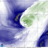
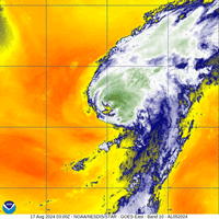
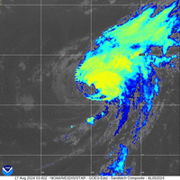
Satellite and surface observations indicate that the center of
Ernesto made landfall on the western side of Bermuda at about 430 AM
AST
, with the National Museum of Bermuda recently reporting light
winds and a central pressure of 972 mb. The system overall has
become less organized as drier air has infiltrated much of the
circulation's southern semicircle
. Earlier aircraft reconnaissance
data supported 75-80 kt as an initial intensity, and with the
degradation in the satellite imagery, 75 kt is chosen as the current
intensity (and operational landfall intensity)
. The Air Force
Hurricane Hunters should be out again in a few hours to sample the
cyclone.

While the current moderate shear is forecast to weaken today, it
will take some time for the vortex to recover from the dry air as
it moves across warm waters north of Bermuda.
Thus little change in
intensity is anticipated in the short term, and re-strengthening
could begin tomorrow. This should be a fairly short-lived window,
however, since Ernesto will be crossing the north wall of the Gulf
Stream on Monday while moving into a strong wind shear environment.
Therefore, steady weakening is forecast for the work week, and
Ernesto is expected to complete extratropical transition near or
just east of Newfoundland. The NHC intensity forecast is largely
an update of the previous one, a bit lower in the short-term to
account for recent guidance. "

---

Passagem do olho sobre o aeroporto pouco antes das 10utc, pressão mínima 973hPa, vento mínimo 13 Km/h, rotação do vento de SE passando por Sul para Oeste e fixando-se.

BWS_aeroporto_20240817-1455utc.png


A entrada de ar seco na circulação de Ernesto destruiu grande parte da convecção profunda, ajudado pelo shear.


Ernesto_AL052024_band11_12fr_20240817-1111.gif


Última edição:
A estação tem sido caracterizada por longos períodos sem ciclones tropicais:

Ver anexo 13854

São pelo menos 17 dias entre o início da formação de Ernesto e o início do próximo ciclone.
A estação está mais fraca que a apanha da amêijoa na Ria Formosa. :sono:

No ano passado em pleno El Niño previam uma época normal e foi uma época mais activa, este ano foram tentar lançar a minhoca para ver se o peixe mordia, tiveram azar, que está a ser uma época fraca, apenas 5 tempestades nomeadas, quando estamos a 20 dias do pico da época.

Virão charters de tempestades nomeadas em Setembro, Outubro e Novembro, só mesmo para quem acredita. :huhlmao:
 
Última edição: