850
WTNT44 KNHC 052048
TCDAT4
Tropical Storm Debby Discussion Number 14
NWS National Hurricane Center Miami FL AL042024
500 PM EDT Mon Aug 05 2024
Debby continues to move over land, and based on surface synoptic
and radar observations the center is estimated to be near the
Florida/Georgia border. Assuming a continued weakening since
landfall, the intensity estimate has been reduced to 45 kt, which is
reasonably consistent with the latest WSR-88D radar velocities
aloft.
Debby continues to move through a weakness in the subtropical high,
and the forward motion has slowed to about 035/6 kt. The cyclone
is expected to turn eastward, while moving quite slowly, in a
region of weak steering currents for the next couple of days. This
motion should bring the center of the system back over water by
late Tuesday. In around 72 hours, a mid-level ridge to the east
of Debby is forecast to build somewhat, and as a result, the center
should move inland over South Carolina and turn northward and
northeastward over the eastern U.S. for the remainder of the
forecast period. The NHC track forecast is similar to the previous
one and is in good agreement with the corrected model consensus,
HCCA, guidance.
The tropical cyclone should continue to weaken while it moves over
land for the next day or so. By late Tuesday, assuming the center
of the system moves back over water, some re-intensification is
forecast. The NHC forecast continues to show only modest
restrengthening due to the uncertainties, although this may be
conservative.
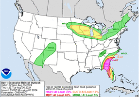
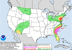
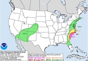
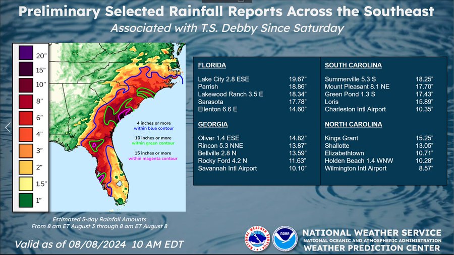
Given the sluggish forward motion of Debby, extremely large amounts
of rainfall over the Southeastern U.S. is anticipated.
Key Messages:
1. Potentially historic heavy rainfall across southeast Georgia and
the coastal plain of South Carolina through Saturday morning will
likely result in areas of catastrophic flooding. Heavy rainfall will
likely result in considerable flooding impacts from portions of
central and northern Florida and across portions of central and
northeast North Carolina through Saturday morning.
2. Dangerous storm surge and tropical storm conditions will spread
northward along the southeast U.S. coast from northeastern Florida
to North Carolina through the middle of the week. Storm Surge and
Tropical Storm watches and warnings have been issued for portions of
these areas. Residents in the Storm Surge watch and warning area
should follow any advice given by local officials.
3. In portions of Florida where Debby has passed, deadly hazards
remain, including downed power lines and flooded areas. Ensure
generators are properly ventilated to avoid carbon monoxide
poisoning. Exercise caution when using chainsaws and power tools,
and drink plenty of water to avoid heat exhaustion.
FORECAST POSITIONS AND MAX WINDS
INIT 05/2100Z 30.5N 82.9W 45 KT 50 MPH
12H 06/0600Z 31.2N 82.1W 35 KT 40 MPH...INLAND
24H 06/1800Z 31.7N 81.2W 35 KT 40 MPH...INLAND
36H 07/0600Z 31.7N 80.1W 35 KT 40 MPH...OVER WATER
48H 07/1800Z 32.1N 79.2W 40 KT 45 MPH...OVER WATER
60H 08/0600Z 32.6N 79.1W 45 KT 50 MPH...OVER WATER
72H 08/1800Z 33.2N 79.2W 50 KT 60 MPH...INLAND
96H 09/1800Z 35.3N 79.1W 30 KT 35 MPH...INLAND
120H 10/1800Z 38.5N 75.5W 30 KT 35 MPH...INLAND
$$
Forecaster Pasch