Previsão e Seguimento de Furacões (Atlântico 2024)
- Thread starter StormRic
- Data de início
-
O novo portal está no ar! Novos meteogramas, cartas, e mais. Mais informações neste tópico
Seguimento Meteorológico: Litoral Norte | Interior Norte e Centro | Litoral Centro | Sul | Açores e Madeira | Livre
Previsões: Curto e médio prazo: até 2 semanas | Longo prazo: mensal e sazonal (Regras e links úteis nos 1ºs posts)
Facebook | Avisos IPMA/Alertas ANEPC
You are using an out of date browser. It may not display this or other websites correctly.
You should upgrade or use an alternative browser.
You should upgrade or use an alternative browser.


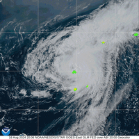
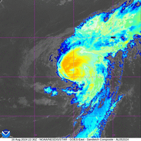
'Ernesto' não perde tempo, já é Tempestade Tropical, continua a organizar-se em torno de um centro já visível:
Previsão de às 0:00 utc de dia 15 ascender à categoria de furacão, segundo o aviso #5 de hoje às 21:00utc:
"
FORECAST POSITIONS AND MAX WINDS
INIT 12/2100Z 16.0N 57.5W 35 KT 40 MPH
12H 13/0600Z 16.2N 60.3W 40 KT 45 MPH
24H 13/1800Z 16.9N 63.4W 45 KT 50 MPH
36H 14/0600Z 18.5N 65.6W 50 KT 60 MPH
48H 14/1800Z 20.9N 67.1W 60 KT 70 MPH
60H 15/0600Z 22.9N 67.8W 70 KT 80 MPH
72H 15/1800Z 25.0N 68.0W 80 KT 90 MPH
96H 16/1800Z 29.4N 66.0W 95 KT 110 MPH
120H 17/1800Z 32.5N 64.3W 95 KT 110 MPH
Trajectória mais próxima de atingir Bermuda no fim do período de previsão de 120 horas.
Possível landfall em Guadeloupe e depois em Porto Rico.
Ensemble isolado do ECMWF
Impacto mais ou menos certeiro na Bermuda, mesmo ao largo haverá devastação, a intensidade Cat.2 parece já bem assente, se não fôr maior.Ensemble isolado do ECMWF
Weathernerds TC Guidance
Porto Rico passará no sector sudoeste, ventos menos intensos; Ilhas Virgem pelo contrário, passa-lhes mesmo por cima, mas ainda é uma TT 55 nós.
Depois da Bermuda o espalhamento do 'spaghetti' é ainda maior, e não está 100% excluída a hipótese de passar na vizinhança norte dos Açores, como TT.
Última edição:
Algumas estações em Guadeloupe com acumulados de 50 a 90mm; Dominica e Martinica também com valores elevados nessa ordem.
Organização do centro em progresso acelerado, braços robustos e outflow praticamente em todos os quadrantes.
Organização do centro em progresso acelerado, braços robustos e outflow praticamente em todos os quadrantes.
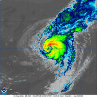
Ernesto é furacão, já a norte de Porto Rico.
O NHC ainda mantém a possibilidade de se tornar 'Major Hurricane', antes de atingir a Bermuda.
A redução na velocidade do movimento ao passar na Bermuda também não é uma boa notícia.
"
000
WTNT45 KNHC 141455
TCDAT5
Hurricane Ernesto Discussion Number 12
NWS National Hurricane Center Miami FL AL052024
1100 AM AST Wed Aug 14 2024
An Air Force Reserve Hurricane Hunter aircraft measured a peak
700-mb flight-level wind of 70 kt northeast of Ernesto's center, and
the crew reported a 50 percent eyewall. In addition, Tail Doppler
radar from the NOAA P-3 aircraft measured winds over 75 kt at an
elevation of 500 meters. Based on these data, Ernesto is upgraded
to a 65-kt hurricane.
Ernesto continues to move northwestward, or 310/14 kt, but is
expected to turn north-northwestward and northward later today and
tonight as it moves through a break in the subtropical ridge caused
by a deep-layer trough off the east coast of the United States. This
trough is expected to leave Ernesto behind later this week, which
should cause a reduction in speed on Saturday and Sunday while the
storm is passing Bermuda. By early next week, a second trough
moving across the eastern United States should cause Ernesto to
accelerate toward the north and north-northeast over the waters
south of Atlantic Canada. The track guidance is in good agreement
during the first 48 hours, and the official forecast was only
shifted slightly westward to account for Ernesto's recent motion.
After 48 hours, there is more divergence in the track models, with
the GFS on the eastern edge of the envelope while the ECMWF shows
less turning and is on the western edge of the envelope. The NHC
forecast has been nudged westward during this period and is very
close to the dynamical hurricane models.
Although Ernesto is moving over very warm waters, the hurricane
might have to deal with bouts of increased shear and nearby dry
air during the next several days. That said, the intensity
guidance shows continued gradual strengthening, and the official
forecast still reflects the possibility of Ernesto becoming a major
hurricane in about 48 hours. Much of the intensity guidance has
come down on the peak intensity this cycle, but for now we'll
maintain continuity and wait to see if this trend continues.
Key Messages:
1. Heavy rainfall will result in locally considerable flash flooding
and mudslides today over the Virgin Islands and into portions of
Puerto Rico.
2. Tropical storm conditions, especially in gusts, are expected to
continue over the Virgin Islands, Puerto Rico, Culebra, and Vieques
through today.
3. Ernesto is likely to bring impacts to Bermuda late this week, and
interests there should monitor the progress of this system. A
Hurricane Watch may be required later today.
4. Even though Ernesto is forecast to remain well offshore the U.S.
East Coast, swells generated by the storm are expected to reach the
area late this week and into the weekend. Beach goers should be
aware of a significant risk of life-threatening surf and rip
currents, and stay out of the water if advised by lifeguards. Surf
and rip currents are also possible on the Virgin Islands, Puerto
Rico, the Dominican Republic, the Turks and Caicos, and the Bahamas
during the next few days.
FORECAST POSITIONS AND MAX WINDS
INIT 14/1500Z 20.5N 67.6W 65 KT 75 MPH
12H 15/0000Z 22.3N 68.7W 70 KT 80 MPH
24H 15/1200Z 24.5N 69.2W 80 KT 90 MPH
36H 16/0000Z 26.6N 68.6W 90 KT 105 MPH
48H 16/1200Z 28.5N 67.2W 100 KT 115 MPH
60H 17/0000Z 30.4N 66.1W 95 KT 110 MPH
72H 17/1200Z 32.0N 65.8W 90 KT 105 MPH
96H 18/1200Z 36.0N 65.4W 85 KT 100 MPH
120H 19/1200Z 42.6N 61.0W 80 KT 90 MPH
$$
Forecaster Berg "
Pelo lado positivo, algum ar seco nas redondezas e episódios de cisalhamento ('shear') durante o trajecto até à Bermuda.
Apesar de poder atingir a Cat.3 24 horas antes, à passagem na Bermuda a intensidade está prevista entrar em diminuição, mesmo assim um Cat.2 e colocando a ilha no pior sector, ENE, tendo em conta a direcção do movimento para Norte.
Última edição:

Ernesto modera a sua intensificação, devido a intrusões de ar seco. Já não está previsto chegar a Cat.3.
No entanto, a trajectória pode levar a parede do eventual olho, ainda em formação, a passar sobre zona sudoeste de Bermuda.

Últimos dois dias, Ernesto ainda a tentar formar um olho. Bermuda aparece no canto superior direito no fim da animação.
No entanto, a trajectória pode levar a parede do eventual olho, ainda em formação, a passar sobre zona sudoeste de Bermuda.
Últimos dois dias, Ernesto ainda a tentar formar um olho. Bermuda aparece no canto superior direito no fim da animação.
Última edição:
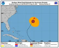
Impacto directo na Bermuda como Cat.2, amanhã cerca das 12:00utc.


Anexos
Última edição:
Rede WU em Bermuda já tem rajadas > 100Km/h em algumas estações, ventos médios nos 60 a 90Km/h.
Mesmo assim, o vento não tão forte como anteriormente previsto, neste aviso #21 não atinge sequer os 90 nós.
FORECAST POSITIONS AND MAX WINDS
INIT 16/2100Z 30.6N 65.6W 85 KT 100 MPH
12H 17/0600Z 31.9N 65.1W 80 KT 90 MPH
24H 17/1800Z 33.1N 64.5W 75 KT 85 MPH
36H 18/0600Z 34.6N 64.0W 70 KT 80 MPH
48H 18/1800Z 36.6N 63.0W 75 KT 85 MPH
60H 19/0600Z 39.8N 61.0W 80 KT 90 MPH
72H 19/1800Z 43.5N 57.0W 70 KT 80 MPH
96H 20/1800Z 50.0N 42.5W 50 KT 60 MPH...POST-TROP/EXTRATROP
120H 21/1800Z 53.5N 22.4W 35 KT 40 MPH...POST-TROP/EXTRATROP

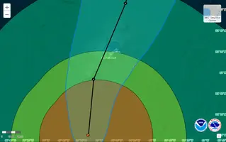
Bermuda já dentro da zona de ventos máximos previstos com intensidade de tempestade tropical, ficará rapidamente toda envolvida pelo centro com ventos de furacão.

A previsão é de que vai mesmo ocorrer landfall na ponta sudoeste da ilha, na próxima madrugada, cerca das 7 utc.
Toda a ilha pode assim passar pelo destrutivo fenómeno da inversão de 180º na direcção dos ventos com força de furacão.
Ernesto está em diminuição dos ventos máximos sustentados e continuará durante toda a passagem pela ilha, de 80 nós para 75 nós (de 148 para 139 Km/h), no entanto é uma situação potencialmente catastrófica para uma ilha tão pequena.

Mesmo assim, o vento não tão forte como anteriormente previsto, neste aviso #21 não atinge sequer os 90 nós.
FORECAST POSITIONS AND MAX WINDS
INIT 16/2100Z 30.6N 65.6W 85 KT 100 MPH
12H 17/0600Z 31.9N 65.1W 80 KT 90 MPH
24H 17/1800Z 33.1N 64.5W 75 KT 85 MPH
36H 18/0600Z 34.6N 64.0W 70 KT 80 MPH
48H 18/1800Z 36.6N 63.0W 75 KT 85 MPH
60H 19/0600Z 39.8N 61.0W 80 KT 90 MPH
72H 19/1800Z 43.5N 57.0W 70 KT 80 MPH
96H 20/1800Z 50.0N 42.5W 50 KT 60 MPH...POST-TROP/EXTRATROP
120H 21/1800Z 53.5N 22.4W 35 KT 40 MPH...POST-TROP/EXTRATROP
Bermuda já dentro da zona de ventos máximos previstos com intensidade de tempestade tropical, ficará rapidamente toda envolvida pelo centro com ventos de furacão.
A previsão é de que vai mesmo ocorrer landfall na ponta sudoeste da ilha, na próxima madrugada, cerca das 7 utc.
Toda a ilha pode assim passar pelo destrutivo fenómeno da inversão de 180º na direcção dos ventos com força de furacão.
Ernesto está em diminuição dos ventos máximos sustentados e continuará durante toda a passagem pela ilha, de 80 nós para 75 nós (de 148 para 139 Km/h), no entanto é uma situação potencialmente catastrófica para uma ilha tão pequena.
Anexos
Última edição:
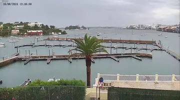
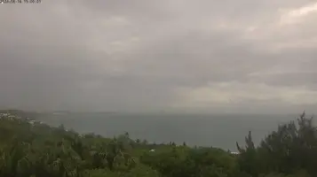
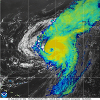
Olho a encobrir pelas nuvens altas das paredes.
Se o olho descobrisse, poderia ser vista toda a ilha no seu interior.
610
WTNT35 KNHC 162043
TCPAT5
BULLETIN
Hurricane Ernesto Advisory Number 21
NWS National Hurricane Center Miami FL AL052024
500 PM AST Fri Aug 16 2024
...ERNESTO MOVING TO THE NORTH-NORTHEAST WITH LITTLE CHANGE IN
STRENGTH...
...STRONG WINDS, DANGEROUS STORM SURGE, AND LIFE-THREATENING
FLOODING EXPECTED TO BEGIN OVER BERMUDA SHORTLY...
SUMMARY OF 500 PM AST...2100 UTC...INFORMATION
----------------------------------------------
LOCATION...30.6N 65.6W
ABOUT 125 MI...205 KM SSW OF BERMUDA
MAXIMUM SUSTAINED WINDS...100 MPH...155 KM/H
PRESENT MOVEMENT...NE OR 35 DEGREES AT 13 MPH...20 KM/H
MINIMUM CENTRAL PRESSURE...969 MB...28.62 INCHES
WATCHES AND WARNINGS
--------------------
CHANGES WITH THIS ADVISORY:
None.
SUMMARY OF WATCHES AND WARNINGS IN EFFECT:
A Hurricane Warning is in effect for...
* Bermuda
A Hurricane Warning means that hurricane conditions are expected
somewhere within the warning area. Preparations to protect life
and property should be rushed to completion.
For storm information specific to your area, please monitor
products issued by your national meteorological service.
DISCUSSION AND OUTLOOK
----------------------
At 500 PM AST (2100 UTC), the center of Hurricane Ernesto was
located near latitude 30.6 North, longitude 65.6 West. Ernesto is
moving toward the northeast near 13 mph (20 km/h). This general
motion is expected to continue with a gradual slowdown tomorrow. An
accelerating northeastward motion is then expected late this weekend
into early next week. On the forecast track, the center of Ernesto
is expected to pass near or over Bermuda tomorrow morning.
Maximum sustained winds remain near 100 mph (155 km/h) with higher
gusts. Some gradual weakening is forecast over the next day or so,
though some re-intensification is possible by early next week.
Ernesto is a large tropical cyclone. Hurricane-force winds extend
outward up to 75 miles (120 km) from the center and
tropical-storm-force winds extend outward up to 275 miles (445 km).
Saildrone SD-1068 located about 25 miles (90 km) west-northwest of
Ernesto's center, recently reported a sustained wind of 67 mph (108
km/h), with a gust to 89 mph (143 km/h). The Bermuda International
Airport also recently reported sustained winds of 41 mph (66 km/h),
with a gust to 63 mph (101 km/h).
The estimated minimum central pressure is 969 mb (28.62 inches).
HAZARDS AFFECTING LAND
----------------------
Key messages for Ernesto can be found in the Tropical Cyclone
Discussion under AWIPS header MIATCDAT5 and WMO header WTNT45 KNHC
and on the web at hurricanes.gov/text/MIATCDAT5.shtml.
WIND: Hurricane conditions are expected on Bermuda Saturday, with
tropical storm conditions already beginning on the island.
STORM SURGE: A dangerous storm surge is expected to produce
significant coastal flooding on Bermuda in areas of onshore winds.
Near the coast, the surge will be accompanied by large and
destructive waves.
RAINFALL: Ernesto is expected to produce total rain accumulations of
6 to 9 inches or 150 to 225 mm in Bermuda. This rainfall will likely
result in considerable life-threatening flash flooding, especially
in low-lying areas on the island.
SURF: Swells generated by Ernesto are affecting portions of the
Turks and Caicos Islands, the Bahamas, and Bermuda. Swells are also
beginning to affect the east coast of the United States and will
likely reach portions of Atlantic Canada by late Saturday. These
swells are likely to cause life-threatening surf and rip current
conditions. Please consult products from your local weather office,
and stay out of the water if advised by lifeguards.
NEXT ADVISORY
-------------
Next intermediate advisory at 800 PM AST.
Next complete advisory at 1100 PM AST.
$$
Forecaster Papin
Anexos
Última edição:
A trajectória aparente vista pelo satélite faz supôr que o centro de Ernesto vai passar não pela zona sudoeste mas ligeiramente a Leste da ilha? 
A confirmar-se, é uma situação bem mais favorável.

A confirmar-se, é uma situação bem mais favorável.
Mas o aviso 21A mantém o mesmo ponto de landfall, no extremo sudoeste.A trajectória aparente vista pelo satélite faz supôr que o centro de Ernesto vai passar não pela zona sudoeste mas ligeiramente a Leste da ilha?
A confirmar-se, é uma situação bem mais favorável.
Por outro lado, parece haver uma intrusão de ar seco pelo quadrante sudoeste do centro, com repercussão na parede sul do olho, e possível shear a desmantelar todo o sector sul.
Talvez já não tenha tempo de reconstituir a parede totalmente até à passagem sobre a Bermuda:
A parede norte está agora muito próxima da ilha, e o vento registado em várias estações tem aumentado até rajadas com os valores máximos seguintes, algumas já em offline, registos de há uma a três horas:
119,1 Km/h vento sustentado 104,6 Km/h
101,4 Km/h
99,8 Km/h
91,7 Km/h
120,7 Km/h vento sustentado 106,2 Km/h
103,0 Km/h
93,7 Km/h
82,1 Km/h
79,8 Km/h
104,6 Km/h
104,6 Km/h
Algumas estações já perderam o registo do anemómetro.
Acumulados de precipitação máximos até agora atingem cerca de 70 a 85 mm.
Anexos
A trajectória aparente vista pelo satélite faz supôr que o centro de Ernesto vai passar não pela zona sudoeste mas ligeiramente a Leste da ilha?
A confirmar-se, é uma situação bem mais favorável.
Este extracto do texto do Aviso 22, emitido há pouco, corrobora as observações acima:
" [...]minimum pressure has been steady around 969 mb.
A blend of the latest flight-level and SFMR winds support an initial intensity of about 80 kt.
Recent microwave images indicate that the vortex is tilted to
the east-northeast with height due to about 20 kt of west-southwesterly vertical wind shear.
The already tilted vortex coupled with continued moderate to strong
shear and possible intrusions of dry air should cause some weakening
during the next day or so. "
A trajectória foi assim corrigida neste último aviso, pondo o centro a passar mais a Leste mas ainda sobre a ilha:
A intesidade dos ventos máximos mantém-se, com o percurso sobre a ilha em decrescendo de 80 nós para 75 nós.
A parede do olho no sector sul está agora desfeita, no momento em que a parede norte se reforça e começa a atingir terra:
Aparentemente e mantendo-se esta trajectória não haverá componente sul na direcção dos ventos na metade sudoeste da ilha, começando de ENE rodarão para norte e depois noroeste. Provavelmente na metade nordeste da ilha sentir-se-á a passagem do olho com uma acalmia temporária e talvez só mesmo no extremo nordeste o vento será previamente de SE com possível rotação para oeste passando por sul.
Última edição:
Partilhar: