Seguimento Meteorológico Livre 2018

  • Thread starter Thread starter Spider
  • Data de início Data de início
Estado
Fechado para novas mensagens.
:lol::lol:
Há pessoas que só ficavam satisfeitas com um F6 ou F7 :p
Só quando rebentam a escala é que há um evento...

Olha, que isso, é fácil falarmos quando não passa no nosso quintal ou perto, eu em Março vi o tornado da janela do meu quarto ao longe e fiquei com medo e se alguém aqui do fórum disser o contrário é um grande mentiroso. :D

Uma coisa, é sentir adrenalina, outra coisa é veres um tornado ao longe ou até passar por cima da cabeça já presenciei essas duas situações e garanto-te que na altura em que passou não dá para racionares, reagires ou teres alguma reacção, mas depois quando passa, começas a raciocinar e dizes que diabo foi isto, vais à rua e na altura estava em casa dum amigo e vês metade das telhas do telhado voaram, árvores e postes caídos, ficas algo parvo a olhares à volta. :wacko:

Uma coisa, é escrever umas coisas aqui no fórum, outra coisa é essa mesma coisa tornar-se realidade e passar literalmente por cima da tua cabeça ou ao longe, garanto-te que mudas logo de opinião, na altura, que dura algum tempo, mas, como a adrenalina, o desejo e a frustração fazem parte da nossa vida e como "doidos" que somos pela meteorologia voltamos a pedir novamente os nossos desejos e volta tudo ao mesmo.

Eu, ainda não perdi o meu desejo de ver um furacão no Algarve, um dia. :D
 
Calma com alarmismos, em particular essas certezas dum sting jet..

Enviado do meu ALE-L21 através de Tapatalk

A Sic já anda a falar que ocorreu uma rajada de 176km/h algures em Aveiro... desconheço qual a fonte deles... mas tornaram isso público.


Enviado do meu iPhone usando o Tapatalk
 
  • Gosto
Reactions: joselamego
A Sic já anda a falar que ocorreu uma rajada de 176km/h algures em Aveiro... desconheço qual a fonte deles... mas tornaram isso público.


Enviado do meu iPhone usando o Tapatalk
Exacto, falaram no valor da rajada, que é impressionante.
Não implica necessariamente advir de um sting jet.
Até pode ter sido, isso depois será analisado, mas vamos lá ver.. Rajadas violentas são a natureza de sistemas tropicais como este, não por causa de sting jets.
Mas volto a frisar que dada a extra tropicalização do sistema até pode ter ocorrido algo do género. Estava era a tentar evitar o alarmismo ou banalização do termo, pois há 50 razões possíveis para rajadas dessa magnitude.

Enviado do meu ALE-L21 através de Tapatalk
 
que é isso de Sting jet?

http://www.severe-weather.eu/theory/what-is-a-sting-jet/

What is a sting jet?
By SWE | Severe weather theory | 12 October 2018
You may have noticed the term ‘sting jet’ used when describing deep Atlantic cyclones and windstorms over the British Isles and Ireland and parts of northern central Europe. Sting jets are associated with the strongest and most damaging windstorms, and cause extremely severe hurricane-force winds. What is a sting jet and how does it form?

What is a sting jet?

A sting jet is a relatively localized jet of rapidly descending cold air inside a deep extratropical cyclone. It affects a small region, compared to th size of the cyclone and lasts only several hours. Destructive winds of over 150 km/h have been attributed to sting jets.

How a sting jet forms

A typical extratropical cyclone consists of two frontal system: the warm front and the cold front. Strong flow, called conveyor belts form ahead of both fronts. A strong flow of cold air develops into the cyclone ahead of the warm front, called the cold conveyor belt. Behind the cold front, cool and dry air flows into the cyclone, forming the dry intrusion.

The cold conveyor belt brings cold, moist air towards the centre of the cyclone, bringing with it precipitation – rain and snow. The dry intrusion brings cool, dry air into the cyclone. As the precipitation from the cold conveyor belt falls into the dry air of the dry intrusion, it evaporates and further cools the air through evaporative cooling.


All this is happening at altitudes up to about 3-4 km. The cooled air is denser than the surrounding air and it descends rapidly to the surface, producing even stronger winds within the intense wind field of the cyclone. The entire region of this cooled, accelerated air is narrow, forming a jet – a sting jet.

The term sting jet comes from its appearance in satellite imagery: they form banded cloud heads, strongly curved into the cyclone – producing the appearance of a scorpion’s tail and stinger. The cloud bands terminate quite sharply, the effect of evaporation in the dry air of the dry intrusion.


Satellite analysis of post-tropical storm Ophelia on October 16, 2017. Notice the branches of “banded cloud head” pushed towards the SW Ireland, indicating that the sting jet structure is likely developed. Source: EUMETSAT

Notable events

Not every deep extratropical cyclone develops a sting jet; in fact, sting jets are rare events. They have so far been confirmed on less than 10 cyclones over western and central Europe. The Great Storm of 1987 produced a sting jet with wind gusts peaking at 217 km/h (recorded at Pointe Du Roc, Grancille, France). Cyclone Oratia (Tora in Norway) in late October and early November of 2000 produced winds gusting up to 176 km/h (Camaret-sur-Mer, France). More recently storm Ulli produced winds up to 172 km/h in Ijmuiden, the Netherlands (early January 2012).
 
E antes que comece a choradeira do género: «a partir de agora vamos estar o mês inteiro sem chover», como já há poucos dias, estava a dar indícios de estar para começar, vamos ter mais calma, porque isto anda tudo muito incerto, sobretudo quando faltam ainda tantos dias e poderá haver instabilidade que entretanto surge e os modelos ainda não consigam detetar. Aliás, às vezes, tudo muda, em menos de nada...
 
E antes que comece a choradeira do género: «a partir de agora vamos estar o mês inteiro sem chover», como já há poucos dias, estava a dar indícios de estar para começar, vamos ter mais calma, porque isto anda tudo muito incerto, sobretudo quando faltam ainda tantos dias e poderá haver instabilidade que entretanto surge e os modelos ainda não consigam detetar. Aliás, às vezes, tudo muda, em menos de nada...

Concordo ainda para mais estamos numa estação de transição logo as previsões a médio-longo prazo são muito mais falíveis.
Para já parece que amanhã vamos ter alguma chuva em todo o país.
 
E antes que comece a choradeira do género: «a partir de agora vamos estar o mês inteiro sem chover», como já há poucos dias, estava a dar indícios de estar para começar, vamos ter mais calma, porque isto anda tudo muito incerto, sobretudo quando faltam ainda tantos dias e poderá haver instabilidade que entretanto surge e os modelos ainda não consigam detetar. Aliás, às vezes, tudo muda, em menos de nada...

Pessoalmente creio que a passagem da Leslie irá permitir alterar o marasmo atmosférico, possibilitando mais instabilidade própria do Outono.
 
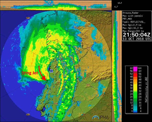
Notícia oficial do IPMA:

Sting jet associado ao Leslie

news-elise-radar.png
2018-10-14 (IPMA)

A estação do IPMA de Figueira da Foz/Vila Verde registou às 21:40 UTC (22:40 hora local) de dia 13 de outubro de 2018, uma rajada de 49 m/s (cerca de 176 km/h). Este valor é atribuído a um fenómeno designado por sting jet.O sting jet é uma forte corrente descendente que, por vezes, se desenvolve no bordo oeste de depressões extratropicais, podendo alcançar a superfície. Nestes casos, as rajadas poderão ser superiores a 150 km/h numa área reduzida, tipicamente situada a sudoeste do núcleo da depressão. A formação deste fenómeno meteorológico foi inicialmente estudada pelo grupo do Professor Keith Browning da Universidade de Reading, no final da década de 80.

As rajadas observadas junto à superfície resultam de processos evaporativos que ocorrem em níveis médios da massa nebulosa da tempestade. Destes processos resultam arrefecimento e consequente transporte descendente do ar para níveis mais baixos, com aceleração progressiva. A designação de sting jet decorre do facto de a assinatura deste fenómeno em imagens de satélite e radar (link para a imagem) se assemelhar à da cauda de um escorpião (sting).

Em Portugal Continental, observou-se um fenómeno semelhante em 23 de dezembro de 2009. No entanto, nessa ocasião, o fenómeno não esteve associado a uma depressão resultante da transição de ciclone tropical para depressão extratropical, como presentemente se verificou. De facto, em 2009, o fenómeno resultou de uma depressão cujo ciclo de vida decorreu integralmente nas latitudes médias. Então, a depressão sofreu um processo de ciclogénese explosiva (rápida e intensa diminuição de pressão atmosférica no seu centro) a que se sucedeu um sting jet.

O valor da rajada de 176 km/h, agora observado, constitui o mais elevado registado em estações da rede meteorológica nacional (máximo anterior de 169 km/h em 17 de outubro de 2015), sendo compatível com as previsões de curto prazo emitidas pelo IPMA, baseadas no modelo do Centro Europeu e do modelo de mesoescala AROME, operado pelo IPMA.


http://www.severe-weather.eu/theory/what-is-a-sting-jet/

What is a sting jet?
By SWE | Severe weather theory | 12 October 2018
You may have noticed the term ‘sting jet’ used when describing deep Atlantic cyclones and windstorms over the British Isles and Ireland and parts of northern central Europe. Sting jets are associated with the strongest and most damaging windstorms, and cause extremely severe hurricane-force winds. What is a sting jet and how does it form?

What is a sting jet?

A sting jet is a relatively localized jet of rapidly descending cold air inside a deep extratropical cyclone. It affects a small region, compared to th size of the cyclone and lasts only several hours. Destructive winds of over 150 km/h have been attributed to sting jets.

How a sting jet forms

A typical extratropical cyclone consists of two frontal system: the warm front and the cold front. Strong flow, called conveyor belts form ahead of both fronts. A strong flow of cold air develops into the cyclone ahead of the warm front, called the cold conveyor belt. Behind the cold front, cool and dry air flows into the cyclone, forming the dry intrusion.

The cold conveyor belt brings cold, moist air towards the centre of the cyclone, bringing with it precipitation – rain and snow. The dry intrusion brings cool, dry air into the cyclone. As the precipitation from the cold conveyor belt falls into the dry air of the dry intrusion, it evaporates and further cools the air through evaporative cooling.


All this is happening at altitudes up to about 3-4 km. The cooled air is denser than the surrounding air and it descends rapidly to the surface, producing even stronger winds within the intense wind field of the cyclone. The entire region of this cooled, accelerated air is narrow, forming a jet – a sting jet.

The term sting jet comes from its appearance in satellite imagery: they form banded cloud heads, strongly curved into the cyclone – producing the appearance of a scorpion’s tail and stinger. The cloud bands terminate quite sharply, the effect of evaporation in the dry air of the dry intrusion.


Satellite analysis of post-tropical storm Ophelia on October 16, 2017. Notice the branches of “banded cloud head” pushed towards the SW Ireland, indicating that the sting jet structure is likely developed. Source: EUMETSAT

Notable events

Not every deep extratropical cyclone develops a sting jet; in fact, sting jets are rare events. They have so far been confirmed on less than 10 cyclones over western and central Europe. The Great Storm of 1987 produced a sting jet with wind gusts peaking at 217 km/h (recorded at Pointe Du Roc, Grancille, France). Cyclone Oratia (Tora in Norway) in late October and early November of 2000 produced winds gusting up to 176 km/h (Camaret-sur-Mer, France). More recently storm Ulli produced winds up to 172 km/h in Ijmuiden, the Netherlands (early January 2012).


muito obrigado, fiquei esclarecido
 
  • Gosto
Reactions: joselamego
Estado
Fechado para novas mensagens.